

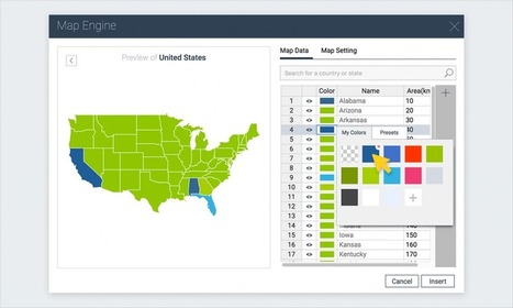

A step-by-step tutorial on how to create an interactive map with Visme, a free online infographic and presentation tool.
Via Micheal polands
Get Started for FREE
Sign up with Facebook Sign up with X
I don't have a Facebook or a X account


 Your new post is loading...
 Your new post is loading...
Your new post is loading...
A step-by-step tutorial on how to create an interactive map with Visme, a free online infographic and presentation tool. Via Micheal polands 

Tom Cockburn's curator insight,
December 13, 2016 3:55 AM
Create your own maps

António Leça Domingues's curator insight,
December 19, 2016 6:44 AM
Criar um mapa interativo com Visme.

Bart van Maanen's curator insight,
December 19, 2016 10:02 AM
Mooie tool om een kaart van data te voorzien.
Sign up to comment
"Business graduates, students, and professionals can sign up today for a free online course to get the Location Advantage."
|
Spatial Digitech is present to you an Interactive maps provide with access to the geographic information by managing your map content ! Via Micheal polands
"Quick 1 minute tutorial on using BatchGeo to create a map. This example shows copying data straight from Wikipedia and mapping, but you can also use spreadsheets, databases, or any other tab delimited dataset."
|


