

Via Robin Good
Get Started for FREE
Sign up with Facebook Sign up with X
I don't have a Facebook or a X account


 Your new post is loading...
 Your new post is loading...
Your new post is loading...
|


Robin Good's curator insight,
December 17, 2013 1:58 PM
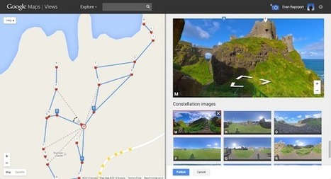
Thanks to "photo spheres" and Google Maps you can now create your own "street view" of any place on earth. To do so you must first shoort "photo spheres" with a dedicated app for your Android smartphone or through your DLSR camera. "Creating Street View from your photo spheres is as easy as connecting the dots into what looks like a “constellation” of stars." You can even connect your photo spheres to our Google's own Street View panoramas. 
niftyjock's curator insight,
December 17, 2013 8:51 PM
I really like this idea, but how can I use it from an educational position not just a gee whizz that's cool perspective? Any Ideas? 
Georges Millet's curator insight,
December 18, 2013 8:31 AM
OK for Xmas, vacation pictures are getting more complex but 360° and posted on google maps ... |


Thanks to "photo spheres" and Google Maps you can now create your own "street view" of any place on earth.
To do so you must first shoort "photo spheres" with a dedicated app for your Android smartphone or through your DLSR camera.
"Creating Street View from your photo spheres is as easy as connecting the dots into what looks like a “constellation” of stars."
You can even connect your photo spheres to our Google's own Street View panoramas.
I really like this idea, but how can I use it from an educational position not just a gee whizz that's cool perspective? Any Ideas?
OK for Xmas, vacation pictures are getting more complex but 360° and posted on google maps ...