


"It’s rare that a video from a brand will spark any real emotion--but a new spot from Google India is so powerful, and so honest to the product, that it’s a testament not only to the deft touch of the ad team that put it together, but to the strength of Google’s current offering."--Forbes
Research and publish the best content.
Get Started for FREE
Sign up with Facebook Sign up with X
I don't have a Facebook or a X account
Already have an account: Login

Geography for All!
1.5K views |
+0 today
 Your new post is loading...
 Your new post is loading...
Your new post is loading...
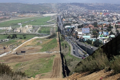
This lesson plan was specifically designed with Arizona examples and aligned to the Arizona state standards, but it be easily adapted. I saw a presentation based on this lesson at the NCGE conference as was incredibly impressed. Also, you'll note that like this one, there are many other lesson plans freely available on the Arizona Geographic Alliance website.
Tags: K12, borders, political, landscape, migration, unit 4 political. Via Seth Dixon 

Jess Deady's curator insight,
April 17, 2014 3:25 PM
This is an important lesson, especially for those who actually live in Arizona/Mexico and have seen the border itself. Learning about the Arizona/Mexican border is important and shouldn't be left solely to teaching it only in those areas. The maps included in the lesson plan are efficient and could be used in the high school setting.
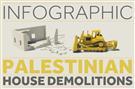
Report by an Israeli non-governmental organisation says 2011 was a record year for Palestinian displacement.
This infographic comes from the group http://visualizingpalestine.org This corresponds with the UN's recent statement that Gaza 'will not be liveable by 2020' given Israeli policies as reported by the BBC: http://www.bbc.co.uk/news/world-middle-east-19391809

Olivia Campanella's curator insight,
October 31, 2018 11:41 AM
This article explains the devastating demolitions that are caused by large -scale military operations such as the War on Gaza in 2008-09. Ten years ago, a 23 year old man (Corrie) was killed by an Israeli army bulldozer when he and his group of activists were acting as human shields to try to stop the Israeli army from demolishing Palestinian homes and clearing out the land around the Palestinian town of Rafah.
So there are a few missing...but still a fun interactive resource for teachers and kids.
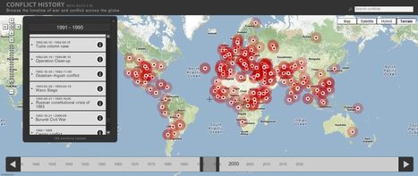
Browse the timeline of war and conflict across the globe.
This database of global wars and conflicts is searchable through space and time. You can drag and click the both the map and timeline to locate particular battles and wars, and then read more information about that conflict. This resource would be a great one to show students and let them explore to find what they see as interesting. This site is brimming with potential.

olsen jay nelson's comment,
August 16, 2012 7:46 AM
This is just what I've been looking for, believe it or not:-)

Paul Rymsza's comment,
August 22, 2012 2:15 PM
the potential of this site is amazing between the interactive learning system and the correlation between the timeline and location. If the human geography class is anything like this i can't wait for it!
|
New nations seem to pop up with alarming regularity. At the start of the 20th century, there were only a few dozen independent sovereign states on the planet; today, there are nearly 200!

Al Picozzi's curator insight,
July 2, 2013 11:38 AM
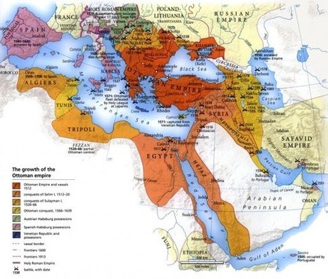
Amazing to see many of the countries and empires that are no longer around. Also with the dissoution of many of the empires it lead's to many of the issues that were are dealiing with today. Splitting the Austro-Hugaraian Empire after WWI along ethnic lines didn't really work and helped to lead to WWII. The Germans in the Sudetenland in Czechoslovakia fro example. See http://en.wikipedia.org/wiki/File:Sudetendeutsche_gebiete.svg for the area of German population. 
Lauren Stahowiak's curator insight,
February 27, 2014 5:01 PM
10 countries that have become nonexistent in the 20th century include Tibet, East Germany and Yugoslavia. These countries have died off because of ethic, religious and cultural falls that were quickly taken over by bigger and more powerful countries. 
Amanda Morgan's curator insight,
October 23, 2014 9:13 PM
Essentially this article boils down to the issues of religion, ethnicity and nationalism. People who are diverse and have different ideas generally cannot all live together under one rule and agree on everything, hence nations split and new ones form to cater to their own beliefs and similarities.
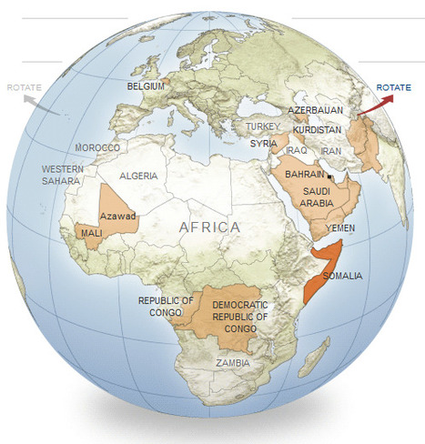
An interactive series of maps show possible new additions to the world’s list of independent nations.
This is great way to show examples of devolution and political instability. Included are 11 potential scenarios where further fragmentation/disintegration might occur or even greater regional integration that would redraw the map. These case studies include: Somalia, Korea, Azerbaijan, Belgium and the Arabian Gulf Union.
Tags: political, devolution, supranationalism, war, autonomy, unit 4 political.

Anna Sasaki's curator insight,
March 24, 2015 8:53 AM
This article is probably one of my favorites I have read so far. It describes perfectly the political instability still present in the world, and that the globe and its boundaries are constantly changing, never staying put for too long. It surprised me at the new borders which most likely are going to happen, such as the unification of parts of Pakistan and Afghanistan. Also, the fact that South Korea is subtly getting ready for the reunification of North and South Korea. Also, there may be devolution in Mali and splintering devolution in the Congo's. This shows devolution as the power in these nations in which are breaking up, such as Belgium and the Flemish peoples. It shows the centrifugal forces behind the breakup of nations, such as ethnicities which vary, or the centripetal forces which bring nations together such as the combination of South and North Korea. 
Caroline Ivy's curator insight,
May 21, 2015 11:12 AM
Devolution/Fragmentation
This article is about nations that could become potentially independent in the near Future, whether due to chronic ethnic incoherence, redrawn governemnt policies, or a growing stateless nation group. Some examples given are an independent Khurdistan, a larger Azerbaijan, and the split of Belgium.
Centrifugal forces are the root of conflict in many countries. These forces include ethnic variety, lack of common language, political instability. These are what may be causing a split in both Belgium (developed country) and Somalia (developing country). There may also be a unification of countries—the map gives an example of the Saudia Arabia, Oman, Yemen, Bahrain, and other melding into one Arabian Gulf Union, of China absorbing Siberia. This does not necessarily herald the presence of centripetal forces, as these countries may be the result of military conquest.
I found these cartograms from an article in the Telegraph and was immediately impressed. The cartograms originated here and use data from the Global Rural-Urban Mapping Project as to create the int...
This series of cartograms shows some imbalanced populations (such as the pictured Australia) by highlighting countries that have established forward capitals. Question to ponder: Do forward capitals change the demographic regions of a country significantly enough to justify moving the capital?

Joe Andrade's curator insight,
August 5, 2013 10:21 PM
Interseting way to visualy map population density. 
Lona Pradeep Parad's curator insight,
May 28, 2014 7:28 PM
It's a creative and vial way to map population density. 
MissPatel's curator insight,
December 16, 2014 3:24 AM
This is from 'worldmapper' - it is a great sight to help you understand using technology the most densely populated areas of various countries. What do you think they are? |


The most intriguing commercial that shows the differences and consequences of what happens between two nations. It shows hurt and feelings no human should have to go through. The biggest thing with this is how that after so much time apart two different people of different religions or countries can come back together and remain friends after so long of conflicting issues.
True, this is a commercial--but what a great commercial to show that the history of of a geopolitical conflict has many casualties including friendships across lines. This isn't the only commercial in India that is raising eyebrows. This one from a jewelry company is proudly showing a divorced woman remarrying--something unthinkable for Indian TV one generation ago.
Questions to Ponder: How does the Indian media reflect the values and beliefs of Indian culture? How does the Indian media shape Indian culture?