


 Your new post is loading...

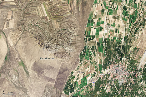

"While people often say that borders aren’t visible from space, the line between Kazakhstan and China could not be more clear in this satellite image. Acquired by the Landsat 8 satellite on September 9, 2013, the image shows northwestern China around the city of Qoqek and far eastern Kazakhstan near Lake Balqash.
The border between the two countries is defined by land-use policies. In China, land use is intense. Only 11.62 percent of China’s land is arable. Pressed by a need to produce food for 1.3 billion people, China farms just about any land that can be sustained for agriculture. Fields are dark green in contrast to the surrounding arid landscape, a sign that the agriculture is irrigated. As of 2006, about 65 percent of China’s fresh water was used for agriculture, irrigating 629,000 square kilometers (243,000 square miles) of farmland, an area slightly smaller than the state of Texas.
The story is quite different in Kazakhstan. Here, large industrial-sized farms dominate, an artifact of Soviet-era agriculture. While agriculture is an important sector in the Kazakh economy, eastern Kazakhstan is a minor growing area. Only 0.03 percent of Kazakhstan’s land is devoted to permanent agriculture, with 20,660 square kilometers being irrigated. The land along the Chinese border is minimally used, though rectangular shapes show that farming does occur in the region. Much of the agriculture in this region is rain-fed, so the fields are tan much like the surrounding natural landscape."
Tags: remote sensing, land use, environment, geospatial, environment modify, food, agriculture, agricultural land change.


It is amazing what irrigation can produce. The border between China and Kazakhstan is a perfect picture of land with irrigation and one without supplied water. Eastern Kasakhstan has farmland but it is only subsidized by natural rainfall whereas on the greener Chinese side of the border it is supplemented with water by the farmers. Great picture!
Seeing such a striking difference between two countries that are so close together is strange and thought-provoking. Knowing a little bit about the two countries can make a world of difference, though. In this case, we have China and Kazakhstan, two countries located in East/Central Asia. Kazakhstan borders China to the west, along the northern part of its western border. Much of China's inland land use is devoted to agriculture, as the majority of its industry is located near its coast. This is evident by the amount of green space seen in the satellite image above. With well over a billion people to feed, China needs to make use of as much of its arable land as possible. Kazakhstan, on the other hand is a much smaller country with much less land devoted to agriculture. Its farmland is mostly large and industrial, as a result of Soviet-era farming and is rain-fed rather than irrigated, like China's.
Knowing the history as well as the economic strengths of a country can therefore be useful in interpreting satellite images such as the one in this article. A lack of knowledge about China and Kazakhstan's economy and history may lead to an assumption that the Chinese are just better farmers than the Kazakhs. This is of course not necessarily true, but what is true is that China has a much larger and more immediate need for agriculture than does Kazakhstan and so devotes more of its land, time, and energy to farming. Likewise, it shouldn't be assumed that Kazakhstan has no need for agriculture at all. Instead, its history has largely influenced its economic strengths and needs, and the result is a country that looks very different from China.
It's crazy to see how much human influences can reshape the landscape, or how things we tend to think of in more abstract terms- like national boundaries- can be very physical in nature. I liked reading about the differing agricultural approaches the two nations take, and being able to see the physical manifestations of those two different approaches so obviously. It's impressive to think that China is able to support such a massive population- one in every 5 people alive on the planet is Chinese- with so little land, and the consequences are plain to see in the image above. Increased irrigation efforts leads to the unnaturally bright green patches in the middle of a relatively dry area, serving as a symbol of man's attempts to bind mother nature to his will. Although not always successful, such attempts appear to be working well here. In contrast, Kazakhstan's population demands vary wildly from that of China's, and its solution for feeding its people can therefore take a more natural, backroads approach, with food production concentrated in a few areas. I wonder what other international borders can be seen so neatly with the naked eye.