
"Unchecked development remains a priority in the famously un-zoned city, creating short-term economic gains for some, but long term flood risk for everyone."
Get Started for FREE
Sign up with Facebook Sign up with X
I don't have a Facebook or a X account


|
Scooped by
Trisha Klancar
onto Geography for All! |
"Unchecked development remains a priority in the famously un-zoned city, creating short-term economic gains for some, but long term flood risk for everyone."

 Your new post is loading...
 Your new post is loading...
Your new post is loading...
"Lets start off the new school year in style! This is a re-imagining of an older resource designed to introduce the subject to new students in a highly visual manner. Feel free to use & share it."

Sally Egan's curator insight,
November 3, 2014 6:10 PM
This is a great introduction to the subject of Geography. Covering both the content, Fieldwork and investigation and teh tools and skills of the subject.

"So how gorgeous is Norway? From its majestic wildlife, captivating Northern Lights shows, and snowy mountains, to its vivid landscapes, and mystifying fjords, Norway is a must-visit destination for anyone who loves the outdoors. Plus, opportunities for hiking, kayaking, glacier climbing, fishing, and skiing are endless! If Noway wasn’t already on your travel bucket list, I bet it is now!"

Deanna Wiist's curator insight,
September 12, 2017 8:59 PM
My wife lived in Norway for 18 months, and her love for this country is infectious. The stunning physical geography leads to some equally magnificent cultural landscapes that were forged in a very rugged, inhospitable environment for early human settlers.
Tags: Norway, place, tourism, physical, Arctic, geo-inspiration, images, art, landscape.
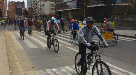
"Bogotá closes its roads every Sunday. Now everyone wants to do it. The Ciclovía is the world’s most successful mass recreation event."

M Sullivan's curator insight,
August 25, 2017 5:06 AM
Could this be a way of making our growing cities more sustainable?

Taylor Doonan's curator insight,
February 13, 2018 8:42 AM
This article shows how important consistency is. Bogota is holding events every Sunday where they close the streets to allow for physical activity in the form of bicycling, walking, running, skateboarding, etc. By doing this they have sparked worldwide interest. Bogota has massive numbers of people who participate every week and many of the people that participate say that they would not get the recommended amount of exercise if this event did not happen every week. This works wonderfully in Bogota, and that is in part due to consistency, this is where many cities struggle. Many of the other cities that were inspired by Bogota are not yet at the level where they can close roads for such a period every week as Bogota does. Another obstacle for other cities is the financial burden, Bogota has a large group of volunteers that are important to the success of the Ciclovia, whereas in many other cities they do not have the volunteer presence so it requires paying police officers overtime which is expensive. This causes many cities to not be able to have Ciclovias frequently which makes the outcomes less substantial. This is a great idea, but it needs to be executed well and the money and work needs to be put in in the beginning for the success to come.
Satellites have been watching us for 40 years. Here's what their images reveal.

Ambre Cooper's curator insight,
June 25, 2015 4:04 PM
This is a cool little video. It even shows the level of Aral Sea we read about. 
Hamdou Wane's curator insight,
June 29, 2015 7:55 AM
Satellites have been watching us for 40 years. Here's what their images reveal 
Alex Smiga's curator insight,
August 6, 2017 8:45 AM
Seth Dixon's insight:
This video is simple entry point into the various applications of remote sensing as well as various human and environmental interactions. This video highlights 5 examples: 1. Deforestation (Brazil) 2. Water Use (Aral Sea) 3. Urban Sprawl (Las Vegas) 4. Energy (Coal in Wyoming) 5. Climate Change (Ice Shelf in Antarctica)
From
www

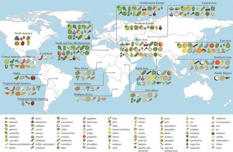
A new study reveals the full extent of globalization in our food supply. More than two-thirds of the crops that underpin national diets originally came from somewhere else — often far away. Via Allison Anthony
Alex Smiga's curator insight,
August 9, 2017 9:50 AM
The next Marvel movie will include origin stories of superfoods.

Tags: K12, map, map archives.
Alex Smiga's curator insight,
January 23, 2016 4:50 PM
Such a great collection of interactive and beautiful maps, hours of entertainment for the North American APHUG nerdus domesticus.

Country that is 100 percent powered by renewable energy taps into new natural resource.
Tags: Iceland, energy.

“American education is largely limited to lessons about the West.”
When I turned 15, my parents sent me alone on a one-month trip to Ecuador, the country where my father was born. This was tradition in our family—for my parents to send their first-generation American kids to the country of their heritage, where we would meet our extended family, immerse ourselves in a different culture, and learn some lessons on gratefulness. My family’s plan worked. That month in Ecuador did more for my character, education, and sense of identity than any other experience in my early life. Tags: place, tourism, education, geo-inspiration.

Matthew Richmond's curator insight,
December 2, 2015 12:06 PM
I completely agree with this article. It is based on the same premise that my spanish teacher always told us. "The only way to truly learn the language and the culture is to actually go there and stay for a period of time." I always assumed she was right based on how easy the class seemed to be for those who had been to Spain or Mexico. The only problem with this theory is the increasingly dangerous state of the world. If I had a child I'm not sure I would allow them to travel anywhere after the Paris attacks. After all, Paris was supposed to be one of the safest places American tourists could visit up until about a month ago. 
Tony Hall's curator insight,
December 3, 2015 11:59 PM
This is a great article. I think it applies to people who live in all developed countries (not just the USA), as well as the privileged people from the less developed places. It touches on a lot of things I care about - seeing, feeling, smelling how other people live. Learning that we are not all the same. Knowing that it is ok to not engage with the "American/Australian/Western Dream". Knowing that it is ok to have your own dreams that are different to other people. 
Sarah Cannon's curator insight,
December 16, 2015 7:15 PM
Being able to travel is a great gift. There is nothing more rewarding than seeing new places and learning about cultures. Unfortunately, the last time that I could afford to travel far from home was when I was young and I didn't understand the amazing opportunity that I had at the time. I traveled to Aruba, and to New Brunswick, Canada. Both amazing places. If I could go anywhere, I'd go to Germany, London, and Ireland as soon as possible. My great grandmother was from England, and my great grandfather was from Canada, I'd like to visit their home towns. Traveling places would definitely be a better learning experience than leaning about a place in school. You get to experience the real thing. Interact with the locals and maybe even get involved with the local traditions. Traveling to learn is definitely an experience worth wild.

“Photographer Vincent Laforet spent the early stages of 2015 photographing the likes of New York, Las Vegas, London, Sydney and Barcelona from a helicopter.”
Tags: urban, megacities, unit 7 cities, images.

"The National Council for Geographic Education (NCGE) continues to both promote and celebrate geographic teaching and learning. Our activities include conducting and gathering research, producing journals and other geography publications, developing curricular resources at the K-12 and University levels, providing professional development opportunities, and organizing an annual conference."

Kaye Morley's curator insight,
November 16, 2015 6:31 PM
Great fact to remember for the next subject selection day!

"Half of Canada’s 33.5 million people live in the red part, the other in the yellow. More population divided maps (Source: reddit.com)" Via Mike Busarello's Digital Storybooks

JeanneSilvey's curator insight,
November 17, 2015 10:09 AM
A great illustration of population concentration and high density in Urban centers. 4.6 million of the remaining 17 million (approx.) live in British Columbia.

Gene Gagne's curator insight,
November 17, 2015 11:41 AM
First economically for trade routes you have the St. Lawrence river which was originally the most influential route for French explorers. You have Toronto the Canada's financial center which forms the core of the "Golden Horseshoe" region, which wraps around the western end of Lake Ontario, population wise a quarter of Canada's population lives here. Politically it makes sense that government would be set up in that area because of the population in that area. Which population leads to the social aspect because all activities of night life, restaurants, businesses, entertainment, malls, etc. are located in this area. And lastly, it makes easy access for United States and Canada to exchange tourism and jobs and goods. 
Corey Rogers's curator insight,
December 13, 2018 1:49 PM
It's crazy to think how big Canada is and yet the majority of the population lives right on the border. Canada is almost in the Arctic Circle so most of the time you're going to have frigid temperatures and inhabitable land so its going to push people closer to the equator.
"E-Waste is a growing problem in our consumer-based society. The geography of e-waste is an ‘out of sight out of mind’ problem that we rarely think about but need to due to the ecological impacts of our collective consumption." http://wp.me/P2dv5Z-1LT
Tags: pollution, sustainability, environment, resources, Ghana, Africa.

Jeremy Hansen's curator insight,
November 10, 2015 11:37 AM
Maybe getting that new iPhone isn't such a good idea, eh?

About a week ago, Denmark made the absolute most out of a particularly windy 24 hours by harnessing its power and producing not only all of its own electricity needs for the day, but enough extra to spread between three neighboring countries. Via oyndrila, Mike Busarello's Digital Storybooks

oyndrila's curator insight,
September 20, 2015 1:54 PM
Cheers to sustainable form of green energy. However one needs to understand the opportunities and constraints of applying the same to different contexts. |
Trisha Klancar's insight:
Have my students doing this on their own everyday!

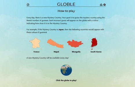
Seth Dixon's curator insight,
February 4, 2022 1:58 PM
I love online geography games (I know, huge surprise). This newest one, The Globle Game, is riffing off Wordle which took the internet and social media by storm recently and I’m hooked. The game is quite simple but don’t let that fool you into thinking that it will be easy. Like the old game where one player searches for an item in the room, with the other players calling out “hot” or “cold,” until the player finds the object, this website shows a globe, and it will color your choice based on how accurate your guess is with a red color ramp (white=ice cold, deep burgundy=red hot). Each day, they have a new mystery country for you to guess, but the globe that it displays does not show international borders. This fun new guessing game requires a strong mental map as well a getting a little bit of luck…something to get the students’ brains fired at the start of class, especially for the competitive types. For fun, there is as a “Night mode” with a purple color scheme, and a CITY version is forthcoming.Think you can beat me? Bring it on!!

melani florence's curator insight,
December 17, 2022 9:16 PM
https://achetersaxendaenligne.com/ https://achetersaxendaenligne.com/Produit/acheter-saxenda-en-ligne/ https://achetersaxendaenligne.com/Produit/acheter-adipex-en-ligne/ https://achetersaxendaenligne.com/Produit/acheter-belviq-en-ligne/ https://achetersaxendaenligne.com/Produit/acheter-dexedrine/ https://achetersaxendaenligne.com/Produit/acheter-du-ritalin/ https://achetersaxendaenligne.com/Produit/ozempic-sans-ordonnance/ https://achetersaxendaenligne.com/Produit/acheter-victoza-en-ligne/ https://achetersaxendaenligne.com/Produit/acheter-vyvanse/ https://achetersaxendaenligne.com/Produit/achetez-qsymia-en-ligne/ https://achetersaxendaenligne.com/Produit/acheter-vyvanse/ https://achetersaxendaenligne.com/Produit/achetez-qsymia-en-ligne/ https://achetersaxendaenligne.com/Produit/acheter-toseina-codeine-sirop/ https://achetersaxendaenligne.com/Produit/acheter-oxycodone-en-ligne/ rapidamente/ https://acheteractiskenan.com/product/acheter-nembutal-liquide/ https://acheteractiskenan.com/product/acheter-norvas-10mg/ https://acheteractiskenan.com/product/acheter-des-pilules-de-nembutal/ https://acheteractiskenan.com/product/acheter-adderall-en-ligne/ https://acheteractiskenan.com/product/acheter-adipex/ https://acheteractiskenan.com/product/acheter-ambien/ https://acheteractiskenan.com/product/acheter-amlodipine-en-ligne/ https://acheteractiskenan.com/product/acheter-buprenorphine-hcl/ https://acheteractiskenan.com/product/acheter-de-lheroine/ https://acheteractiskenan.com/product/acheter-codeine-en-ligne/ https://acheteractiskenan.com/product/injection-de-morphine/ https://acheteractiskenan.com/product/acheter-phentermine-en-ligne/ https://acheteractiskenan.com/product/acheter-tren-a-en-ligne/ https://acheteractiskenan.com/product/achetez-trenbolone-enanthate/ https://acheteractiskenan.com/product/acheter-trenarapid-en-ligne/ https://acheteractiskenan.com/product/acheter-de-la-cocaine/ https://acheteractiskenan.com/product/acheter-demerol/ https://acheteractiskenan.com/product/acheter-desoxyn/ https://acheteractiskenan.com/product/buy-dexedrine-online/ https://acheteractiskenan.com/product/acheter-dilaudid-en-ligne/ https://acheteractiskenan.com/product/acheter-du-fentanyl/ https://acheteractiskenan.com/product/acheter-du-suboxone/ https://acheteractiskenan.com/product/acheter-du-xanax-vert/ https://acheteractiskenan.com/product/acheter-norvas-10mg/ https://acheteractiskenan.com/product/acheter-oramorph/ https://acheteractiskenan.com/product/acheter-rubifen/ https://acheteractiskenan.com/product/acheter-subutex/ https://acheteractiskenan.com/product/acheter-vicodin/ https://acheteractiskenan.com/product/achetez-vyvanse/ https://acheteractiskenan.com/product/acheter-de-la-cocaine/ https://acheteractiskenan.com/product/acheter-de-lheroine/ https://acheteractiskenan.com/product/acheter-methadone-en-ligne/ https://acheteractiskenan.com/product/acheter-ms-contin/ https://acheteractiskenan.com/product/acheter-oxazepam-en-ligne/ https://acheteractiskenan.com/product/acheter-oxynorm-en-ligne/ https://acheteractiskenan.com/product/acheter-phentermine-en-ligne/ https://acheteractiskenan.com/product/acheter-plegine-en-ligne/ https://acheteractiskenan.com/product/acheter-rubifen/ https://acheteractiskenan.com/product/acheter-stilpane-sirop-100ml/ https://acheteractiskenan.com/product/acheter-toseina-2-ml-solucion/ https://acheteractiskenan.com/product/acheter-histaverin-2-mg-ml/ https://acheteractiskenan.com/product/acheter-lheroine-black-goudron/ https://acheteractiskenan.com/product/acheter-la-cocaine-colombienne/ ordonnance achete victoza en ligne achete oxycodone achete methadone en france achete morphine deurope achete en europe acheter actiskenan France acheter actiskenan achete klonopin acheter actiskenan acheter de loxycodone acheter toseina 2-ml solucion acheter oxycodone mallinckrodt acheter de loxycodone sandoz acheter de loxycodone acheter ativan en ligne acheter percocet acheter tramadol acheter morphine acheter codeine en lign injection de morphine acheter 4-aco-dmt acheter 5-meo dmt acheter dmt polvo de ketamina acheter flakka a-pvp acheter mdma crystal comprar etizolam acheter du soma en ligne acheter ultram en ligne comprar micro mushrooms acheter seconal sodium comprar cianuro de sodio acheter psilocybe cubensis poudre de nembutal golden teacher crecer rapidamente acheter nembutal liquide acheter norvas 10mg acheter nembutal acheter adderall en-ligne acheter adipex kopen 5-meo dmt kopen adderall kopen desoxyn kopen dexedrine kopen dmt netherland kopen flakka kopen mdma crystal kopen morphine kopen natriumcyanide kopen nembutal kopen nembutal-poeder kopen oxycodon kopen oxycontin kopen percocet kopen phentermine kopen suboxone strips kopen subutex nederlands kopen vicodin kopen vyvanse kopen ultram kopen lsd-sheet kopen nembutal pillen kopen nembutal liquid kopen oxycodon hcl https://kopenoxycodone.com/ https://kopenoxycodone.com/producten/ https://kopenoxycodone.com/product/ambien-online-kopen/ https://kopenoxycodone.com/product/buprenorfine-kopen/ https://kopenoxycodone.com/product/carisoprodol-nederland-kopen/ https://kopenoxycodone.com/product/fentanyl-citrate-kopen/ https://kopenoxycodone.com/product/fentanyl-poeder-kopen/ https://kopenoxycodone.com/product/fentanyl-pleister-kopen/ https://kopenoxycodone.com/product/gouden-leraar-paddenstoelen/ https://kopenoxycodone.com/product/hydromorphone-kopen/ https://kopenoxycodone.com/product/ketamine-poeder-kopen/ https://kopenoxycodone.com/product/koop-5-meo-dmt/ https://kopenoxycodone.com/product/koop-adderall-online/ https://kopenoxycodone.com/product/koop-desoxyn-online/ https://kopenoxycodone.com/product/koop-dexedrine/ https://kopenoxycodone.com/product/koop-dmt-netherland/ https://kopenoxycodone.com/product/koop-flakka-a-pvp/ https://kopenoxycodone.com/product/koop-mdma-crystal/ https://kopenoxycodone.com/product/koop-morphine/ https://kopenoxycodone.com/product/koop-natriumcyanide/ https://kopenoxycodone.com/product/koop-nembutal-pentobarbital/ https://kopenoxycodone.com/product/koop-nembutal-poeder/ https://kopenoxycodone.com/product/koop-oxycodon/ https://kopenoxycodone.com/product/koop-oxycontin-online/ amlodipine/ https://dolorendo.com/product/comprar-etizolam/ https://dolorendo.com/product/comprar-fentanilo-en-linea/ https://dolorendo.com/product/comprar-flakka-a-pvp/ https://dolorendo.com/product/comprar-heroina-en-linea/ https://dolorendo.com/product/comprar-metanfetaminas-en-linea/ https://dolorendo.com/product/comprar-micro-mushrooms/ https://dolorendo.com/product/comprar-norco-en-linea/ https://dolorendo.com/product/comprar-polvo-nembutal/ https://dolorendo.com/product/trenarapid-10x-1ml/ https://dolorendo.com/product/compre-nembutal-liquido/ https://dolorendo.com/product/comprar-psilocybe-cubensis-b/ https://dolorendo.com/product/comprar-quaaludes/ https://dolorendo.com/product/comprar-rubifen-espana/ https://dolorendo.com/product/comprar-soma-en-linea/ https://dolorendo.com/product/comprar-tilidin-en-linea/ https://dolorendo.com/product/comprar-trenbolone-enanthate/ https://dolorendo.com/product/comprar-trankimazin/ comprar klonopin en linea comprar morfina en linea comprar ritalin en linea comprar cristal-mdma en linea comprar seconal-sodium en linea comprar comprar-4-aco-dmt en linea comprar 5-meo-dmt en linea comprar Rubifen espana comprar soma en linea comprar suboxone en linea comprar subutex en linea comprar-ultram comprar xanax verde buy xanax comprar vyvanse en linea comprar vicodin en linea golden teacher comprar psilocybe comprar polvo- comprar micro mushrooms comprar metanfetaminas comprar flakka comprar fentanilo en linea comprar extasis en linea comprar-etizolam comprar-5-meo-dmt buy-seconal-sodium buy-nembutal-pills buy-nembutal-liquid Oxycodone comprar Oxycodone https://comprarmorfina.com/ https://comprarmorfina.com/productos-comprar-dilaudid/ https://comprarmorfina.com/product/comprar-adderall-en-linea/ https://comprarmorfina.com/product/comprar-adipex-en-linea/ https://comprarmorfina.com/product/comprar-ambien-en-linea/ https://comprarmorfina.com/product/comprar-buprenorfine-en-linea/ https://comprarmorfina.com/product/comprar-dexedrina/ https://comprarmorfina.com/product/comprar-desoxyn-en-linea/ https://comprarmorfina.com/product/comprar-dilaudid/ https://comprarmorfina.com/product/comprar-dmt-en-linea/ https://comprarmorfina.com/product/comprar-heroina-en-linea/ https://comprarmorfina.com/product/comprar-ketamina/ https://comprarmorfina.com/product/comprar-klonopin/ https://comprarmorfina.com/product/comprar-morfina/ https://comprarmorfina.com/product/comprar-oxicodona-en-linea/ https://comprarmorfina.com/product/comprar-oxycontin-en-linea/ https://comprarmorfina.com/product/comprar-percocet-en-linea/ https://comprarmorfina.com/product/comprar-rubifen-espana/ https://comprarmorfina.com/product/comprar-soma-en-linea/ https://comprarmorfina.com/product/comprar-suboxone-en-linea/ https://comprarmorfina.com/product/comprar-subutex-en-linea/ https://comprarmorfina.com/product/comprar-ultram-en-linea/ https://comprarmorfina.com/product/comprar-xanax-verde/ https://comprarmorfina.com/product/buy-xanax/ https://comprarmorfina.com/product/comprar-vyvanse-en-linea/
"Unchecked development remains a priority in the famously un-zoned city, creating short-term economic gains for some, but long term flood risk for everyone."
Deanna Wiist's curator insight,
September 12, 2017 8:56 PM
Houston's development boom and reduction of wetlands leave region prone to more severe flooding. Here is a great map of the change in impervious surfaces in the region from 1940 to 2017--when you combine that with record-breaking rainfall the results are catastrophic. But a local understanding of place is critical and this viral post--Things non-Houstonians Need to Understand--is pretty good.
Tags: physical, fluvial, water, coastal, urban, planning, transportation, architecture. 
Vincent Lahondère's curator insight,
October 31, 2017 1:27 PM
Un dossier sur les inondations à Houston (en anglais). La présentation est très originale.
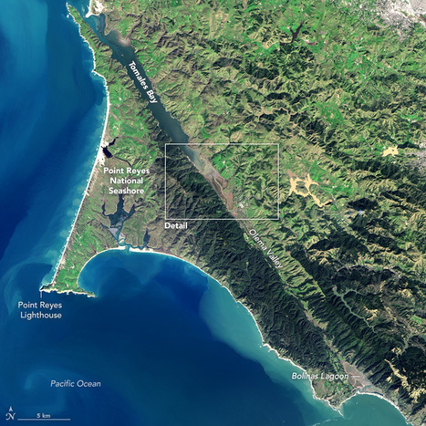
"Tomales Bay lies about 50 kilometers (30 miles) northwest of San Francisco, along the edges of two tectonic plates that are grinding past each other. The boundary between them is the San Andreas Fault, the famous rift that partitions California for hundreds of miles. To the west of the Bay is the Pacific plate; to the east is the North American plate. The rock on the western shore of the Bay is granite, an igneous rock that formed underground when molten material slowly cooled over time. On the opposite shore, the land is a mix of several types of marine sedimentary rocks. In Assembling California, John McPhee calls that side “a boneyard of exotica,” a mixture of rock of 'such widespread provenance that it is quite literally a collection from the entire Pacific basin, or even half of the surface of the planet.'"
Tags: geomorphology, remote sensing, tectonics, geology, California, coastal, physical.
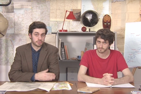
Mark Cooper-Jones and Jay Foreman, the Map Men, tap into a rich vein of geographical quirks to teach through comedy
Jeremy Hansen's curator insight,
August 29, 2016 12:43 PM
Holy heck these guys are good! I'd like to see more of these Map Men videos. I'm sure at least some of my 8th graders can appreciate some British wit.

"Follow America's favorite vegetable from field to factory — to see how potatoes grow and how they're turned into chips."

Sophie Wilson's curator insight,
August 31, 2016 10:33 AM
This video shows the process of potatoes moving from farm to factory in America and how they are turned into chips. It shows how the potatoes are planted, grown and turned into chips.

Residents can't feel most of them, but there have been a lot of earthquakes in Puget Sound lately.
Tags: disasters, physical, tectonics.

“ Described as “The Lungs of the Planet”, the Amazon rainforest is the world’s largest natural resource being a key player in what the health of our planet is concerned.”
Via Lindsay Coogan

“ Beijing is currently experiencing the worst pollution it has seen so far this year”
Via Mike Busarello's Digital Storybooks
Trisha Klancar's insight:
Amazing how clear things were for the Olympics!

“ The Gobi Desert expands by about 1,400 square miles every single year.”
Via Clairelouise, Mike Busarello's Digital Storybooks

“ Geography Awareness Week begins today. This is my favorite academically-themed week of the year because I have enjoyed learning about geography and teaching geography for as long as I can remember.”
Via Mike Busarello's Digital Storybooks
“Geography of the United States & Canada”
Tags: urban, prezi, planning, urbanism, architecture, North America.
"The evolving role of cities and regions presents planning challenges as urban areas are work to achieve particular social, economic and environmental goals. This video explores a range of cities to examine how fully integrated planning, design, engineering and management capabilities can help to improve cities."
Tags: urban, planning, urbanism, architecture.
“ Vessel positions tracking based on AIS data. Real-time ship locations, port arrivals and departures.”
Via Seth Dixon, Mike Busarello's Digital Storybooks
|


Houston's development boom and reduction of wetlands leave region prone to more severe flooding. Here is a great map of the change in impervious surfaces in the region from 1940 to 2017--when you combine that with record-breaking rainfall the results are catastrophic. But a local understanding of place is critical and this viral post--Things non-Houstonians Need to Understand--is pretty good.
Tags: physical, fluvial, water, coastal, urban, planning, transportation, architecture.
Un dossier sur les inondations à Houston (en anglais). La présentation est très originale.