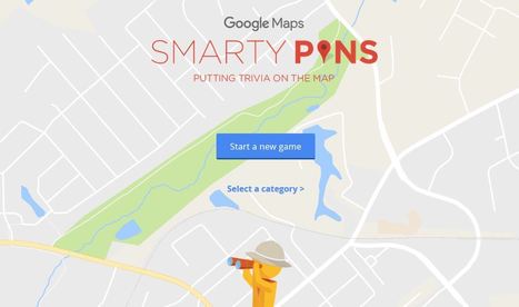
Smarty Pins is a Google Maps based geography and trivia game.
Via Mike Busarello's Digital Storybooks
Get Started for FREE
Sign up with Facebook Sign up with X
I don't have a Facebook or a X account


 Your new post is loading...
 Your new post is loading...
Your new post is loading...
Smarty Pins is a Google Maps based geography and trivia game. Via Mike Busarello's Digital Storybooks 
No comment yet.
Sign up to comment
"Google rolled out its new Maps design...from a navigational tool to a commercial interface and offers the clearest proof yet that the geographic web—despite its aspirations to universality—is a deeply subjective entity."
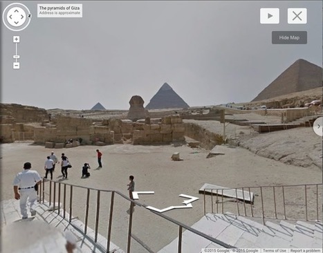
"Join Queen Rania Al Abdullah of Jordan and wander through the lost city of Petra in Street View http://goo.gl/ixZRa9 "

Mark Rasi's curator insight,
April 19, 2015 3:36 PM
Amazing what will happen when these big players continue to throw resources at education!
"Over the last 10 years, businesses, scientists and hobbyists from all over the world have been using Google Earth Pro for everything from planning hikes to placing solar panels on rooftops. Google Earth Pro has all the easy-to-use features and detailed imagery of Google Earth, along with advanced tools that help you measure 3D buildings, print high-resolution images for presentations or reports, and record HD movies of your virtual flights around the world. Starting today, even more people will be able to access Google Earth Pro: we're making it available for free. To see what Earth Pro can do for you—or to just have fun flying around the world—grab a free key and download Earth Pro today." Tags: google, mapping, virtual tours, geospatial, edtech. Via dilaycock

magnus sandberg's curator insight,
February 4, 2015 2:39 AM
To be honest, I have no idea what GEPro does more than the free version. But I intend to find out! 
Rich Schultz's curator insight,
February 11, 2015 11:21 AM
Spread the word and get your Google Earth Pro FREE today!!!
Authorities use Google Earth to crack down on illegal activities.

Giselle Figueroa's curator insight,
September 28, 2014 8:19 PM
I think this is a good tool to the authorities to keep a eye on criminal people. Some people may feel that some one is always watching you because of these, but lets see the good side, this could help the police to find criminals or illegals activities. In my opinion these is a good idea. 
Jacob Crowell's curator insight,
October 27, 2014 11:51 AM
Using geographic technology to catch criminals seems like a great use of technology in the digital age. But this is a massive breach of privacy on a global scale. Now with satellite imagery, there is fewer and fewer geographic factors that allow for privacy. No longer can someone move into the woods for solitude, in the past geography could be used as a way to isolate oneself from others, now with technology like "google earth", the globe has become easier to monitor all landscapes and areas. People will have to ask themselves how much they are willing to sacrifice in terms of security. If being monitored everywhere you go means less dangerous activities taking place it may be worth the risk, but we are putting a lot of faith in the fact that those in charge of these technologies will use them responsibly.

Smarty Pins is a Google Maps based geography and trivia game.

flea palmer's curator insight,
July 7, 2014 10:33 AM
This is really good fun - I got gold (14/15) not sure how many miles though! 
Tom Franta's curator insight,
July 10, 2014 9:54 AM
An interesting way to get anyone interacting with Google Maps...

Students and educators have a wealth of learning and productivity tools available to them online. Google offers some of the highest-quality resources on the web to meet all your study and teaching needs, and all you need to access them is an internet connection. Via Ilkka Olander

Mikko Hakala's curator insight,
March 9, 2014 10:10 AM
+ 9 things every student should be able to do with Google Drive http://www.educatorstechnology.com/2014/03/9-things-every-student-should-be-able.html
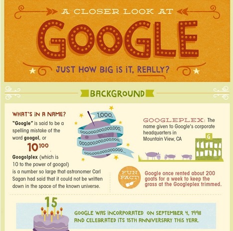
Here are some stats and facts that may give you an idea of how big Google really is. Via Beth Dichter

Beth Dichter's curator insight,
December 31, 2013 10:53 AM
Google is a company that many of us rely on for email, to search, for their free apps and more. Check out this infographic to learn more about Google's background, finances and the many services that it provides. This would be a good infographic to kick off a classroom discussion about what it means to be the company that holds so much of your information and what they have the potential to do with this information. |
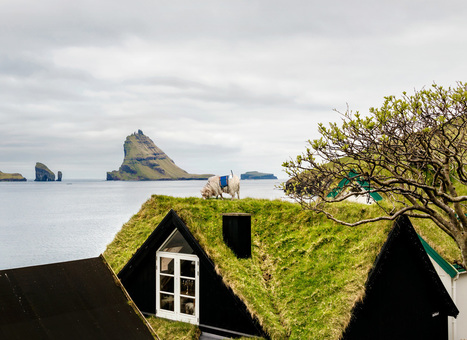
"How do you get Google to visit your small, remote island group with its Street View vehicles, and digitize your roads for the benefit of locals and tourists alike? If you are the Faroe Islands, then you exploit your local resources to roll your own Street View, in the hopes of attracting Google's attention. Behold: Sheep View 360, a solar-powered 360-degree camera, mounted on a sheep's back. Sheep View takes advantage of one great Street View feature: You can upload your own images to Google's service. So Durita Dahl Andreassen, working for the tourist site Visit Faroe Islands, decided to kick-start the Faroe Islands' entry by putting the camera on a sheep and letting it wander free, then uploading the photos." Via Scarpaci Human Geography

From
www

"Two archaeologists, who recently published their findings in the American Schools of Oriental Research, used Google Earth satellite images and drone photography to identify the outline of an enormous monument buried beneath sand and time at the UNESCO World Heritage site in Jordan." --Motherboard

Zavier Lineberger's curator insight,
March 29, 2018 3:38 PM
(Middle East) Using modern technology, archaeologists have discovered a new monument hidden underground in Petra. The find, dated around 150 B.C., is thought to be a ceremonial site with two platforms, pottery. columns, and a staircase carved out of stone. It is amazing that there are still new finds like this in the 21st century, but the history of the Middle East is so incredibly old, with so many extinct civilizations, that archaeologists will probably keep making new breakthroughs.

brielle blais's curator insight,
April 1, 2018 4:40 PM
Physical geography can be really cool as understanding the current land helps to also understand the past. Researchers finding new monuments like this in Petra shows the importance of knowing the land around you, or someplace important like where the UNESCO World Heritage Site.

In lieu of a whirlwind trip round the world, check out some highlights courtesy of Google Earth. Via Tom D'Amico (@TDOttawa)

Aiming to get kids to understand and solve real-world math problems, one teacher developed a tool that uses Google Earth.
Tags: math, google. Via Mike Busarello's Digital Storybooks

Anna Sasaki's curator insight,
March 22, 2015 2:42 PM
There is a new programme which helps students truly understand the usage of math skills being taught in school. It is a game that students may play, which actually put the math skills learned in school into play. This solves the time old question of "when will I ever use this?" It is very fun and uses Google maps to manifest questions for each sections from grades 5-10. It is putting more use of the Google maps and helps others learn about geography as it is using the maps. This shows another way to use Google maps, which uses a GIS system to track locations. The online maps presents many different opportunities of teaching others, through various methods, and geography can be present in any topic shown. Geography can help others learn through spatial recognition in the case of math, and many other ideas. 
Woodstock School's curator insight,
March 23, 2015 1:39 AM
“Pray tell us, what's your favorite number?"... 
Matthew Connealy's curator insight,
March 23, 2015 10:26 PM
The use of Google Earth is becoming beneficial to Thomas Petra, a middle school teacher that is trying to make learning more interesting. By using Google Earth, he is able to teach lessons in a more interactive and applicable way. An example of this would be when his students learned about distance through the Alaskan dog sledders and their travels. The students are able to learn much more than the conventional way of learning and are able to gain a better sense of the phenomena around them.
Although this was used in a mathematical setting, Google Earth is only just beginning. Geography students would greatly benefit from this usage of the app, and more teachers should learn to harness this style of teaching. Students will be able to gain a better sense of what is going on around them, and know more about the world they live in.
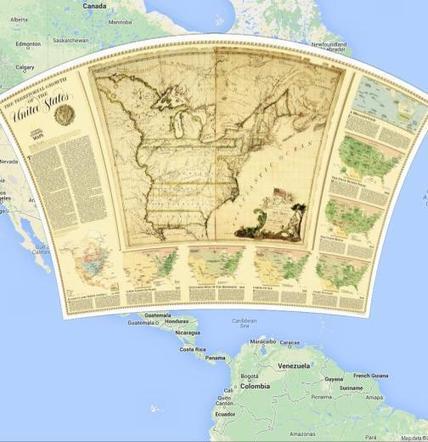
The National Geographic Society has been inspiring people to care about the planet since 1888. National Geographic Maps publishes more than 100 new print maps annually and is a leading developer of digital map content found in websites and award-winning mobile apps. All proceeds from the sale and licensing of National Geographic maps go to support the Society's vital exploration, conservation, research and education programs. www.natgeomaps.com Via Mike Busarello's Digital Storybooks

"Google is using a new technology to automatically generate 3D buildings from 45-degree angle aerial photography made by overlapping passes of aircraft. The aerial photos are combined to create 3D models."

Annenkov's curator insight,
April 16, 2014 12:46 AM
This technology of visualization I would name "3D landscape" 
Mirta Liliana Filgueira's curator insight,
April 16, 2014 8:40 PM
Tecnología para generar imágenes en 3D con Google Earth 
Sid McIntyre-DeLaMelena's curator insight,
May 29, 2014 2:06 PM
Google Earth has made the Earth easier to decipher and examine in a geographical sense of location and place by being able to see multiple layers. This article goes into the 3D designs and usage of aerial photography to create 3D images.
"While Germans tend to talk about privacy and how the internet takes away our freedom, chief Almir of the Surui tribe in Brazil came up with an idea when he first came in contact with Google Earth. He saw it as a great tool to visualize the devastation of the rainforest. With the help of Google providing the knowledge and equipment he started the project and provided an unfiltered perspective never seen before. This is a growing project on a growing problem that should matter to all of us. It’s never a service or product itself that matters; it’s what you do with it. Check the video and see for yourself." Globalization inherently brings serendipitous juxtapositions. In this clip we see the merger of geospatial technologies to protect indigenous cultures and their cultural ecology. Via Seth Dixon, geo-pickmeup.com

Amy Marques's curator insight,
January 29, 2014 11:03 PM
This is a great example that shows the positive and negative effects of globalization. The negative effects is that the chief Almir and the Surui tribe have changed from their original roots through contact with the outside world. Their language and clothing has been altered because we see the cheif speaking brazilian portugese and the tribe wearing western clothing. The positive aspect is that they are trying to protect their ancient rain forests by using the benefits of globalization. I think its great that Google is helping this tribe, of course Google is getting tons of recognition for this, but they are doing wonders for this group of people. With the technology provided the tribe will be able to be put on the map and educate its group. 
chris tobin's curator insight,
February 6, 2014 11:12 AM
this will help protect the forest and decrease deforestation hopefully, also protecting global climate and environment. How does this affect the large companies in paper mills, timber and especially the specialty tree plantations.........roads cutting through the rainforest ......wildlife........ 
Michael Amberg's curator insight,
March 23, 2015 10:54 PM
This is an interesting way to educate people around the world of the places that most people don't think about. its interesting to see the technology with the tribes people to see how it actually benefits their folk culture by preserving the land. |