

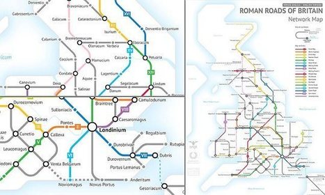

The map of the UK's Roman roads, towns and cities, was created by Mr Sasha Trubetskoy, a student studying statistics at the University of Chicago.
Via Kent College History
Get Started for FREE
Sign up with Facebook Sign up with X
I don't have a Facebook or a X account


 Your new post is loading...
 Your new post is loading...
Your new post is loading...
The map of the UK's Roman roads, towns and cities, was created by Mr Sasha Trubetskoy, a student studying statistics at the University of Chicago. Via Kent College History 

Kent College History's curator insight,
July 25, 2017 7:01 PM
'From 43 – 410 AD, the Romans built around 2,000 miles of roads across the UK, designed to allow troops to move quickly, and providing vital routes for commerce, trade and the transportation of goods. An ambitious student has now re-imagined the UK's Roman-era roads as a modern subway system.'
Sign up to comment
|


