Human Interest
198.8K views | +5 today
Follow
Human Interest
Your new post is loading...
Scooped by Skuuppilehdet
Scoop.it!

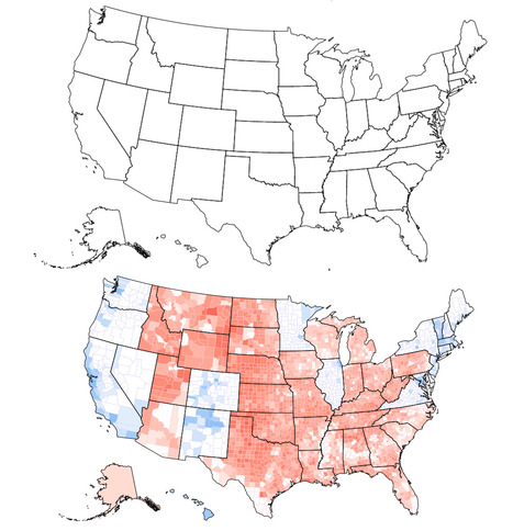
Clinton would have won if the United States looked like the top map

Clinton would have won if the United States looked like the top map | Human Interest | Scoop.it
Can you tell what’s wrong with this map of the United States? I’ll give you a hint: Look near the Great Lakes and the Gulf of Mexico. Spot the problem yet? A further hint: Look at the border of Wisconsin and Illinois as well as the Florida Panhandle. See it now? The Wisconsin-Illinois border is slightly more southern and the Florida Panhandle is slightly shorter.
Corey Rogers's curator insight, December 13, 2018 4:14 PM
The electoral college is such a mess that it shouldn't be relied on for figuring out the President. With the misrepresentation of the map and the continuous gerrymandering the United States should use the popular vote category instead of the Electoral College. 
Rescooped by Skuuppilehdet from U.S HISTORY SHACK : MIKE BUSARELLO
Scoop.it!

220 years of US population changes in one map

Every 10 years, the Census Bureau calculates the exact center of the US population. Here's what that statistic shows about our history.

Via Mike Busarello's Digital Storybooks
No comment yet.
Scooped by Skuuppilehdet
Scoop.it!

State Borders Were Drawn in the Distant Past. Is It Time to Reimagine Our Map?

State Borders Were Drawn in the Distant Past. Is It Time to Reimagine Our Map? | Human Interest | Scoop.it

"Most state borders were drawn centuries ago, long before the country was fully settled, and often the lines were drawn somewhat arbitrarily, to coincide with topography or latitude and longitude lines that today have little to do with population numbers.  Most state borders were drawn centuries ago, long before the country was fully settled, and often the lines were drawn somewhat arbitrarily, to coincide with topography or latitude and longitude lines that today have little to do with population numbers."


Tags: cartography, mapping, visualizationregions, gerrymandering, political, mapping, census, density.

Scooped by Skuuppilehdet
Scoop.it!

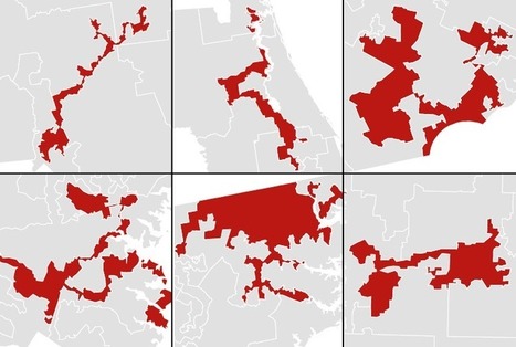
America’s most gerrymandered congressional districts

America’s most gerrymandered congressional districts | Human Interest | Scoop.it
A brief overview of crimes against geography in the 113th Congress.
Courtney Barrowman's curator insight, May 30, 2014 3:15 PM

unit 4

Michael E Herrera's curator insight, July 26, 2017 6:29 PM
Is Gerry Mander Jim Crow's cousin?
Yvonne Pierce's curator insight, July 13, 2019 10:21 PM
It will be very interesting to see how the districts change after the Census 2020.  Eyes wide open to gerrymandering.


Rescooped by Skuuppilehdet from AP HUMAN GEOGRAPHY DIGITAL STUDY: MIKE BUSARELLO
Scoop.it!

Judges Find Wisconsin Redistricting Unfairly Favored Republicans

Judges Find Wisconsin Redistricting Unfairly Favored Republicans | Human Interest | Scoop.it
A federal panel called the 2011 redrawing of Wisconsin Assembly districts an unconstitutional gerrymander, ruling in a case that could go to the Supreme Court.

Via Mike Busarello's Digital Storybooks
No comment yet.
Scooped by Skuuppilehdet
Scoop.it!

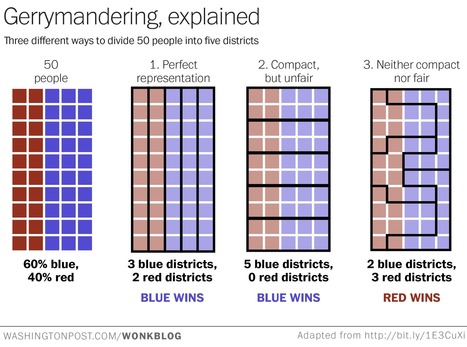
Gerrymandering Visualized

Gerrymandering Visualized | Human Interest | Scoop.it
By simplifying gerrymandering we see how problematic it really is.
Lucas Olive's curator insight, April 28, 2017 8:19 PM
This article relates to what we have been learning in class because it talks about how gerrymandering works and how it manipulates political geography. My opinion on this topic is that it's a big problem for people who oppose the side that is gerrymandering and it's really unfair to the opposing side.
Kassie Geiger's curator insight, April 30, 2017 9:35 PM
This is related to world cultural geography by the word gerrymandering. Gerrymandering is the process of redrawing legislative boundaries for the purpose of benefiting the party in power. Gerrymandering is completely and utterly unfair to the powerless party. The process is practically setting up zones of people who are, for instance, democratic, that means that particular county (region, district, etc.) is democratic majority and possibly have republican minority, therefore the democrats win that county (region, district, etc).
Mr Mac's curator insight, June 13, 2017 10:19 AM
Unit 4 - Gerrymandering 
Scooped by Skuuppilehdet
Scoop.it!

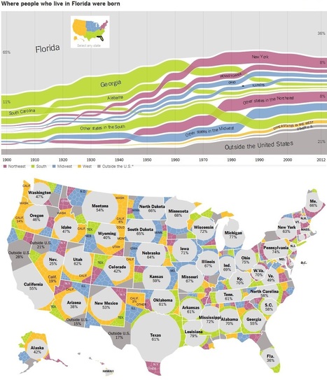
Where We Came From, State by State

Where We Came From, State by State | Human Interest | Scoop.it
Charts showing how Americans have moved between states for 112 years.
MsPerry's curator insight, August 17, 2014 3:42 PM

APHG-U2

samantha benitez's curator insight, November 22, 2014 2:51 PM

Charts showing how Americans have moved between states for 112 years. helps show the nature of change around the United States and its impact in the enviorment.