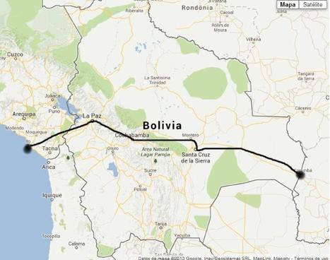
"It might be a strip of sand without even a jetty but a small stretch of the Pacific coast now harbors Bolivia's dream of regaining a coast and becoming a maritime nation. The landlocked Andean country has won access to a desolate patch of Peru's shoreline, fueling hopes that Bolivia will once again have a sea to call its own. President Evo Morales signed a deal yesterday with his Peruvian counterpart, Alan García, allowing Bolivia to build and operate a small port about 10 miles from Peru's southern port of Ilo. The accord, sealed with declarations of South American brotherhood, was a diplomatic poke at Chile, the neighbor that seized Bolivia's coast and a swath of Peruvian territory in the 1879-84 war of the Pacific."
Having access to a coast provides many benefits to a country. If Peru follows through and allows Bolivia use of the coast, both countries may profit from the deal. If Bolivia is unable to gain access to the coast it will continue to be dependent on neighboring countries.
A deal between the two countries of Peru and Bolivia giving the latter a small stretch of land to call their own. This is a win for Bolivia who had been left without a coastal shore since Chile took their land in the late 19th century during the War of the Pacific. As both a sign of friendship and a dig on Chile, Peru leased out a "1.4 square mile patch of sand" to Bolivia for 99 years. Morales, the leader of Bolivia, knows how much a port would do for the country being able to export more goods, dock naval vessels and bring more trade and investment into the country.
Today, to the southeast of Block Island, there are five new structures rising from the ocean. These are the towers of the Block Island Wind Farm (BIWF), the first offshore wind energy installation in the United States. The turbines will generate 30 megawatts of energy; providing electricity to 17,000 households on Block Island and coastal Rhode Island (McCann, 2016), and replacing the diesel generators that previously powered New Shoreham. The turbines are on schedule to begin turning in November 2016 once commissioning is complete.
"The ESRI storymap on climate refugees does a phenomenal job sampling locations in the world that experience migration effects as a result of climate change. Attached is a guided worksheet that accompanies the ESRI Climate Migrant Storymap."
Global warming has raised global sea level about 8" since 1880, and the rate of rise is accelerating. Rising seas dramatically increase the odds of damaging floods from storm surges.
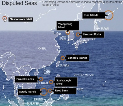
Competing territorial claims have led to maritime disputes off the coast of Asia. See a map of the islands at issue.
This is an nice interactive map that allows the reader to explore current geopolitical conflicts that are about controlling islands. This is an good source to use when introducing Exclusive Economic Zones, which is often the key strategic importance of small, lightly populated islands.
This interactive page gives relevant information about islands that are disputed over in southeast Asia. I liked it because you could see the information in context with the map.
This is like a game of Monopoly when people try and get all the houses or businesses. Except this is real life and real isles. Whose is whose? How does Asia decide where and how the EEZ's should be divided.
considering that half of the nations involved are island nations, this is hardly surprising. every nation has issues with their neighbors. even the us and Canada dispute some territory. but these disputes can hardly end as well, when half of these nations have fought wars with each other for most of their histories.
We learned last year that many of the effects of climate change are irreversible. Sea levels have been rising at a greater rate year after year, and the Intergovernmental Panel on Climate Change estimates they could rise by another meter or more by the end of this century.
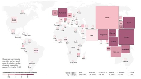
A new analysis of sea levels and flood risk around the world offers more evidence that the brunt of climate change will not be borne equally.
More than a quarter of Vietnam’s residents live in areas likely to be subject to regular floods by the end of the century. Globally, eight of the 10 large countries most at risk are in Asia. These figures are the result of a new analysis of sea levels and flood risk around the world, conducted by Climate Central and based on more detailed sea-level data than has previously been available. The analysis offers more evidence that the countries emitting the most carbon aren’t necessarily the ones that will bear the brunt of climate change.
In this article the author discusses the risk of flooding in many different locations of the world. He claims about 2.6 percent of the world's populations. That's a big percentage considering all the people of the planet.
Flooding is a major risk when it comes to the world we live in especially for Southeast Asia, some areas will be below sea level which shows how the the climate changes are affecting the flood risks caused by global carbon emission. A study from this article shows that eight our of ten of the largest countries will be at the risk of being flooded and below sea level. The major question is how can this carbon emissions be lower? If the carbon is lower then the sea level will rise and less countries will be at risk, this is mainly focusing on Southeast Asia. Yes, we can not change the climate changes but by keeping the land clean and taking care of the environment the flood risk and sea level change could get out of risk level.
If the weather continues at the rate it is at then about 2.6 percent of the global population which is approximately 177 million people will be living in a place at risk of regular flooding. Flooding can cause a lot of damage to homes, crops and people physically because flooding is not just a little amount of water.
The largest country at risk with people in danger from the map is China, I liked the way this map worked because you can see from the boxes how many people are going to be affected by the flooding. Instead of just having numbers, giving a better visual for people with the boxes and their sizes.
It's like watching the land on Earth change right in front of our eyes. According to this map, if global carbon emissions stay as they currently are and sea levels can be affected about as much as expected, 2.6 million people of the global population will live in a high risk flood zone; this wipes out 177 million people!
The USGS says sea-level rise and sinking could claim up to 4,677 square miles of land along the coast if the state doesn’t implement major restoration plans.
(North America topic 2) This interactive map is an excellent tool for researching how low-lying delta areas such as southern Mississippi have changed over recent years, and for what underlying reasons. Although human activity has been largely responsible for the loss of valuable marshland (land development, canals, levees), it's nice to know that in some cases human activity has actually helped to promote it, even if it was not originally intended to do so.
It makes you think: what other unintended consequences human actions are having on the environment in other places and on other scales?
Is very crazy that soon these land will be gone. What really makes me worry is that in a few years all these land in Louisiana will be gone, what is going to happen to all these people who is living right know in these areas? What action government will take? This is a very worrying situation.
If I lived in Louisiana, I wouldn’t settle down near the coast. 2,000 square miles will be lost in about 80 years. The water will have risen to 4.3 feet, and Louisiana has an average height of 3 feet. That leaves everything outside of the protective levees underwater in due time. Many pipelines that serve 90% of the nation’s offshore energy production and 30% of its gas and oil supply that goes to 31 different states and over 2 million people will all need to find a new place to live if this continues. Once home to 700 people south of New Orleans is now home to nearly 15 residents. The water level has already been ruining homes for people in Louisiana.
Canada has dispatched two icebreakers to map the Arctic seabed beneath the North Pole to support a bid to extend the country's maritime territory deeper into the waterways at the top of the world.
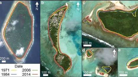
"The tiny Pacific nation of Tuvalu – once thought to be under threat from rising sea levels – has grown the size of California's Disneyland over the past 40 years. It's mostly thanks to waves dumping extra sediment, sand and gravel on shore lines, according to research by Auckland University scientists. The study, published in the Nature Communications journal on Friday, was the first in-depth look at how much each of Tuvalu's 101 islands have changed over the decades."
A costly plan to build floating islands shows how climate change is pushing the search for innovative solutions, but some critics ask who will ultimately benefit.
Unlike the many maps we have seen that show what Florida, Boston, or some other coastal location would look like with higher sea levels, the figure above compares the iconic outline of Louisiana with the present-day outline of its dry land. An important caveat is that some of the removed areas are wetlands, meaning they are not under water all the time, but those lands are not available for most human uses (aside from fishing), so this outline warrants attention.
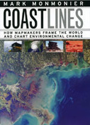
In the next century, sea levels are predicted to rise at unprecedented rates, causing flooding around the world, from the islands of Malaysia and the canals of Venice to the coasts of Florida and California. These rising water levels pose serious challenges to all aspects of coastal existence—chiefly economic, residential, and environmental—as well as to the cartographic definition and mapping of coasts. It is this facet of coastal life that Mark Monmonier tackles in Coast Lines. Setting sail on a journey across shifting landscapes, cartographic technology, and climate change, Monmonier reveals that coastlines are as much a set of ideas, assumptions, and societal beliefs as they are solid black lines on maps.
Most of the 1,000 or so Marshall Islands, spread out over 29 narrow coral atolls in the South Pacific, are less than six feet above sea level — and few are more than a mile wide. For the Marshallese, the destructive power of the rising seas is already an inescapable part of daily life. Changing global trade winds have raised sea levels in the South Pacific about a foot over the past 30 years, faster than elsewhere. Scientists are studying whether those changing trade winds have anything to do with climate change.
This post shows how climate change is currently impacting small island nations such as the Marshall Islands. Pacific Sea waters are rising and driving families out of their homes. It is changing the entire physical geography of the land. It is also changing the political climate between different nations as the battle over climate control continues and countries react in different ways to ideas and suggestions, or even laws stating nations like the United States would have to pay money to help those other countries being flooded.
Catastrophic property destruction from sea level rising is (at this point in time) inevitable. A number of Islands that serve as homes for hundreds of thousands of people will be devastated and most likely destroyed. These spots will become uninhabitable and dangerous. The Marshall Islands is just one area that will suffer this fate. Trying to save the islands is a moot point. What is now needed is a discussion about ethics and fiscal responsibility. Industrialized and developed nations led the way in destroying parts of the planet and should be held accountable. To become wealthy, these affluent nations collectively sacrificed the world's fragile environment. With this understanding, people of the Marshall Islands should be given a new home and compensation for their losses. Fortunately, the United States has a deal with the Marshall Islands to allow people to immigrate to the U.S. While this is a good start, these people will require job training, education, homes, transportation, and funds to rebuild their lives. Instead of spending massive amounts of tax dollars on military and defense budgets, Congress needs to reassess its values and priorities. By committing to ethical and noble leadership, the U.S. will have more international prestige and leverage to build defense coalitions and negotiate through diplomatic means. An immense single-nation military-industrial complex will be less relevant. By reducing military spending, this country can address problems like the sinking Marshall Islands and our nation's energy needs. How would it look if the U.S. became a true champion of justice and a despotic nation like China attacked the U.S.? The world would be outraged. The U.N. would condemn the aggressor. Alliances could step forward, allowing America to step back as the world police officer which no one ever asked us to be.
Islands are already at a disadvantage of losing land for a few reasons. First the fact that the older the island gets the more corroding that takes place under the sea. Another reason is they are in the middle of no where so relocation is not easy, costly and not many countries these days are willing to take people in. The Marshall islands like I am sure many other islands are facing in recent years is global warming causing sea levels to rise. So know they have another reason to worry about losing lands. The global warming that takes place on earth never effects the contributors, it almost always effects the little guys who cannot doing anything to fight back. They just get to watch there homes be destroyed because of big time nations. More attention needs to be brought to the subject of global warming and everything and one who is negatively effected by it. What if we were in there shoes, we surely would change our ways then.
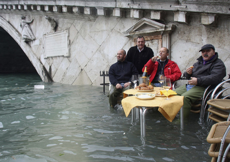
this was interesting mother nature shows us once again that she is in control by showing us how easily our seemingly strong structures can be swept away
"Though uninhabited and full of melting ice caps, the Arctic is surprisingly an appealing piece of real estate. Many countries have already claimed parts of the region. So who technically owns the North Pole? And why do these nations want it so bad?"
The video discusses a big topic in discussion today - Who really owns the North Pole? Although the North Pole is uninhabited, many countries have claimed to take ownership of the vast majority of land (or, ice). Canada has already claimed that the North Pole is part of its nation. Russia has put up Russian flags on the North Pole (such as underwater) but does that really make North Pole a Russian territory? The media plays a role in this by offering different opinions on who should and who deserves the right to own the North Pole. You might read a Canadian article that lists all the outright reasons why the North Pole is or deserves to be a Canadian territory.
In my opinion, I don't understand how the United nations can be seen as an entity that, essentially, controls who would have rights to a place like the North Pole(technically, not owned by anyone). I, naively, understand the basics of the U.N. In short, it is an organization that was formed, post-WW I or II, as a governing board for world-issues.
With that being said, how can they believe that their "law" is the all-powerful one? If I'm a leader of a country who is not a member of the U.N., do I really care what they say? I just find it odd that this narrator speaks about the issue while holding the U.N. as a supreme authority. I know that this video is just a quick fun type of video but it leaves me with wanting to hear the perspective of a non-U.N. member. But a very interesting topic, none the less.
(North America topic 7) Just like geography and history textbooks become obsolete the day they're published (thanks to Professors Dixon and Bonin for the phrase!), the same can be said for maps and icons.
This article uses the example of Louisiana's state highway signs, which show the outline of the state... well, according to data from the 1930s. While an updated sign isn't as pretty, it does bring about the truth that the landscape is changing, and on a larger scale this is true for the entire world, especially with influence from development and climate change. However, I can relate to the other side of the argument too. Tossing the old LA symbol would toss a historical reminder of what once was. The same can be said for New Hampshire's Old Man of the Mountain road signs and license plates. I'd hate to see the profile removed, especially since what is symbolizes still lives on in the hearts of many residents and visitors, including myself.
Scientists have issued a new warning to the world’s coastal megacities that the threat from subsiding land is a more immediate problem than rising sea levels caused by global warming.
A new paper from the Deltares Research Institute in the Netherlands published in April identified regions of the globe where the ground level is falling 10 times faster than water levels are rising - with human activity often to blame.
In Jakarta, Indonesia’s largest city, the population has grown from around half a million in the 1930s to just under 10 million today, with heavily populated areas dropping by as much as six and a half feet as groundwater is pumped up from the Earth to drink.
The same practice led to Tokyo’s ground level falling by two meters before new restrictions were introduced, and in Venice, this sort of extraction has only compounded the effects of natural subsidence caused by long-term geological processes.
Casey Lysdale's curator insight, November 28, 2016 12:43 PM
Could subsistence in megacities becoming a bigger threat than sea level rise? The population rise caused an increase in groundwater extraction practices which made the ground sink over six feet in Indonesia's largest city. The solution is to stop pumping groundwater and seek alternative forms of obtaining drinking water. Effects of land subsistence combined with rising sea levels can leave many coastal cities into project Atlantis.
To get content containing either thought or leadership enter:
To get content containing both thought and leadership enter:
To get content containing the expression thought leadership enter:
You can enter several keywords and you can refine them whenever you want. Our suggestion engine uses more signals but entering a few keywords here will rapidly give you great content to curate.


 Your new post is loading...