As fecal waste and bacteria flow from hog lagoons into the water supply, North Carolina is revisiting a contentious battle between the pork industry, health experts and environmentalists.
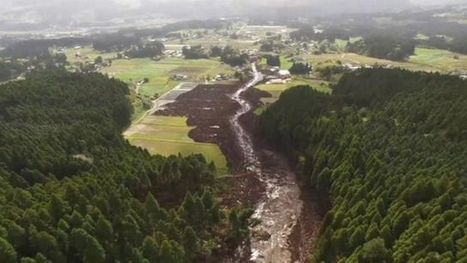
In regions where hog farm density is high, there is an overall poor sanitary quality of surface waters. The presence of mass-scale swine and poultry lots and processing plants in a sandy floodplain – a region once dotted by small tobacco farms – has long posed a difficult dilemma for a state where swine and poultry represent billions of dollars a year for the economy. [Past] hurricane’s environmental impact in North Carolina were so severe in part because of the large number of hog lagoon breaches. Following Hurricane Matthew, the department has counted 10 to 12 lagoons that were inundated, with floodwaters topping the berms and spreading diluted waste.
Unlike the many maps we have seen that show what Florida, Boston, or some other coastal location would look like with higher sea levels, the figure above compares the iconic outline of Louisiana with the present-day outline of its dry land. An important caveat is that some of the removed areas are wetlands, meaning they are not under water all the time, but those lands are not available for most human uses (aside from fishing), so this outline warrants attention.
Three decades later, it’s not certain how radiation is affecting wildlife—but it’s clear that animals abound.
It may seem strange that Chernobyl, an area known for the deadliest nuclear accident in history, could become a refuge for all kinds of animals—from moose, deer, beaver, and owls to more exotic species like brown bear, lynx, and wolves—but that is exactly what Shkvyria and some other scientists think has happened. Without people hunting them or ruining their habitat, the thinking goes, wildlife is thriving despite high radiation levels.
When the giant fault line along the Pacific Northwest ruptures, it could be our worst natural disaster ever.
The Cascadia subduction zone remained hidden from us for so long because we could not see deep enough into the past. It poses a danger to us today because we have not thought deeply enough about the future. The Cascadia situation, a calamity in its own right, is also a parable for this age of ecological reckoning, and the questions it raises are ones that we all now face. How should a society respond to a looming crisis of uncertain timing but of catastrophic proportions? How can it begin to right itself when its entire infrastructure and culture developed in a way that leaves it profoundly vulnerable to natural disaster?
Thanks to advancements in technology and dedicated researchers who often forgo glory and fame, Americans are now aware of another impending natural disaster that is likely to ruin the lives of so many of our fellow citizens. This article reminded me of the impending doom of climate change and the resulting ecocide. So many of us, even people who put faith in religion, trust scientific discovery enough to acknowledge that these are realities we face as a society. Not all of us are totally brainwashed to dismiss this a secular, liberal hoax. Despite this awareness, not much - if anything - is being done to address or prepare for the awaiting earthquake and tsunami. This fact affirms that the United States' population is largely out-of-touch with reality. In a fantasy world, like ours, we are too special and superior (perhaps chosen by destiny or God) to suffer such a drastic and radically dreadful experience of nature. The delusion prevents us from acting sooner, rather than later. What comes to mind is the Netherlands as they train their population and renovate their urban centers to flow with the tides of climate change. They have the knowledge (like we do) but the difference is they have embraced it and in a communal way have decided to take action. These Europeans are adapting to their situation. This sheds light on the irony of the United States; a powerful, resource rich, skilled, and highly capable country that is falling a part because of what? Greed for wealth? Selfishness? Dare-I-say foolishness? Maybe it is indifference in an age of modernity - devoid of true human connection but full of technological bliss and distraction? Add the Cascadia subduction zone to modernity's doom list now including unsustainable wealth inequality, overextended military policies, climate change complacency/denial, mass incarceration, obesity, mass shootings, a post-fact world, and an Opioid health epidemic. These are BIG problems that need bold strokes. Simply put, many people with wealth and power do not feel a connection to their countrymen and countrywomen to allow a government - acting on behalf of the masses - to do something. And, that is a key link. Businesses seeking to make a profit do not want regulations and adaptation to interfere. The cost of addressing these problems is a potential loss of money-making as consumers modify their behavior and new policies require more funding through taxes.
As this article relates to geography and my aforementioned class-warfare rant: the Earth is indisputably a complex planetary system that has always been totally indifferent to human wants and needs. The planet has no obligation or will to act in our best human interests. We, as a people, must respond to the planet. When it shakes, we must brace or move. In other words, we must take action or experience the consequences of inaction. Crony capitalism, excessive wealth, and a government held hostage by corporate interests which prioritize profit over people are serious hurtles. The wealthy and powerful should realize that they need US - the 90% of people that lack significant amounts of disposable income. 90% is a large chunk of civilization! There is no wealth and prosperity if there is no healthy civilization on which to build a business or exercise entrepreneurial abilities. It is time to confront greed by recognizing our collective humanity - a humanity shaped and informed by geographically determined experiences.
An insightful and honestly, scary article. Discussing the inevitable earthquake that would devastate the pacific northwest, but not knowing when it could occur makes me never want to even visit. The Cascadia earthquake which could or more likely would send a tsunami straight into Oregon. Learning from the Seaside, Oregon superintendent that three of the four schools under his charge will go from five to fifteen feet above sea level to as much as forty-five below would shake anyone to their core. So what has the state done to remedy this? Nothing, unfortunately. With no Early-warning system, he describes how one elementary school will be trapped, as they will have no escape. With the growing ocean waters on one side and a roadless bog on the other, these students have nowhere safe to go. This reminds me of the question, would you rather know how you will die or when you will die? Waiting with no clue when the impending doom will occur until it happens is too much for me. I recommend get out now and get out quick unless the state figures out a warning system, then just get out quick.
Yes, we have some serious earthquakes on the San Andres fault and in Japan but we're overlooking the one along the Pacific Northwest. An out roar has to be made for people to be more notified of the Cascadia subduction zone, so people can prepare for tragedy. We need to realize that the way these plates move can make a major ripple effect on our way of life.
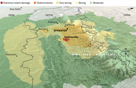
The May 12 7.3 magnitude aftershock was one of many that followed the April 25 earthquake that shook Nepal. Why is this part of the world such a hotbed of tectonic activity?
Geography determines human activity, and not the other way around; that has been the theme of this course, and it holds true as we look at the devastating impacts of earthquakes in the nation of Nepal. Sitting right over one of the most active plate boundaries in the world, with the Indian subcontinent being violently forced under the rest of Asia, Nepal is therefore the home of both the infamous Himalayan Mountains and numerous earthquakes, varying in severity and frequency. As violent and as costly as they are, violent earthquakes are just another part of life in Nepal, as are other natural events in other parts of the globe, and the people who call it home adjust their lives accordingly, through a variety of means. However, nothing can prepare anyone for the extremes of earth's power, and the violent earthquake that shook the nation to its very core in May has left behind a great deal of human suffering and destruction. I hope that those who lost their homes and businesses are already well along on their path to recovery, although I don't think it's possible to every truly heal from such a traumatic experience, at least not completely.
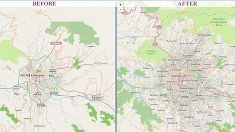
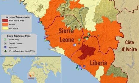
This is a great example of how using technology can benefit people. In Nepal, in which they are an area where they can get many earthquakes, they used "crisis maps" to their advantage. First off as the article state Nepal is a very difficult country to navigate and especially after the earthquake with roads being destroyed it could make it nearly impossible. With people in dire need of supplies they had to get creative. So here they used a software system called "OpenStreetMap." It is, as described in the article, a Wikipedia for mapmakers. Basically, anyone can add to the map from an amateur to a professional map maker. By allowing everyone to help they were able to make more accurate maps and faster ways to reach someone that had a need for supplies, these became the crisis maps that they would use. Going into the future this software will continue to be important in Nepal as you can constantly edit the maps and continue to find better and more efficient ways to get to place to place. Other countries with these issues should look towards Nepal and take preemptive action so that when a disaster does strike they will be ready and will not lose valuable time right after a disaster. A very interesting article in which I did not previously know much about.
We have learned that the Himalayas are growing everyday while our Appalachians in the united states are shrinking. What does this all mean? In the platonic spectrum it means in Nepal, earthquakes.
"The signs that something’s wrong are not immediately obvious, but, once you see them, it’s hard to tune them out. Curbs at nearly the exact same spot on opposite sides of the street are popped out of alignment. Houses too young to show this kind of wear stand oddly warped, torqued out of sync with their own foundations, their once-strong frames off-kilter. This is Hollister, California, a town being broken in two slowly, relentlessly, and in real time by an effect known as 'fault creep.' A slow, surreal tide of deformation has appeared throughout the city."
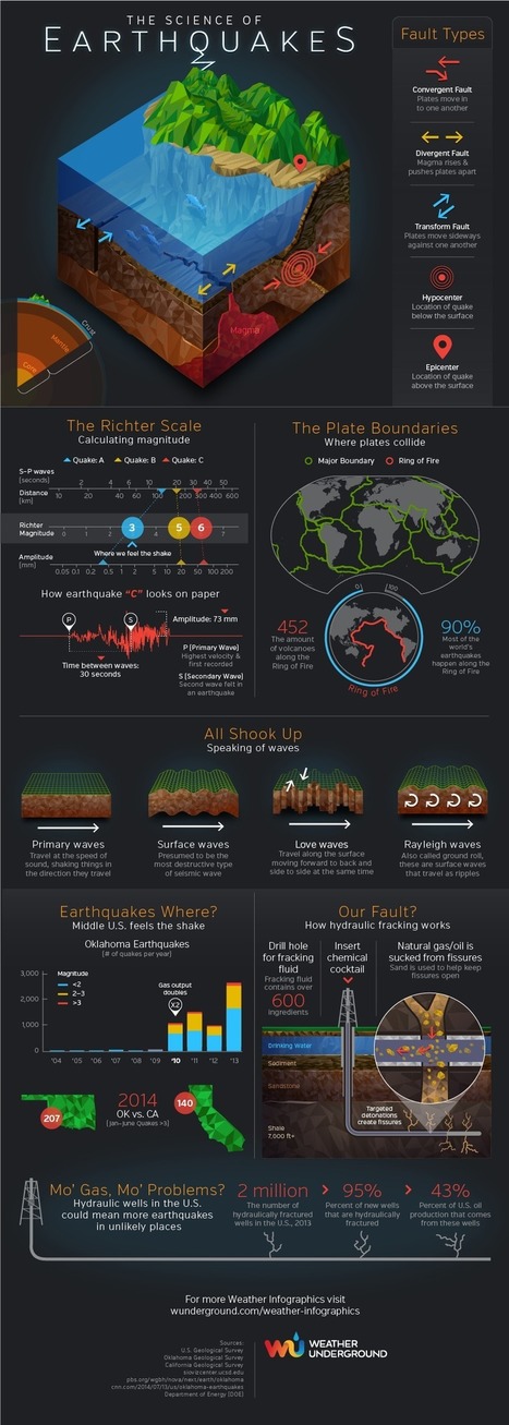
From fault types to the Ring of Fire to hydraulic fracking, the Earthquakes infographic by Weather Underground helps us understand the complexities of what shakes the ground.
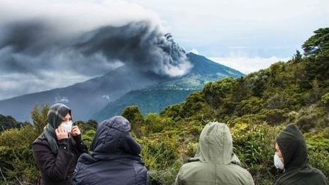
"Mount Tavurvur, on Papua New Guinea's New Britain Island, erupted on August 29, 2014, throwing ash (gray-brown areas of September image) over surrounding areas. Its last major eruption was in 1994. Tavurvur is a stratovolcano, a volcano consisting of alternating layers of lava and ash, and is located along the eastern edge of the Rabaul Volcanic Complex. Simpson Harbor forms part of the much larger (mostly submerged) Rabaul Caldera."
There may not be may words on this article but a picture can speak a thousands words as I've seen when looking at these pictures. The climate changing is not only affecting the way people live but it is also affecting the structure of the world's atmosphere such as the melting glacier in Peru called Qori Kalis. The ice and glacier has retreated so much that the ice has melted and created a small lake right in the middle where the huge glacier used to stand. What is going to happen to the work if these type of disasters keep occurring? What other types of physical changes will occur? Any type of change in the land can affect how people live, how they find shelter and any other aspect of living. These type of physical changes are not only happening far from the United States but also in the United States such as California. It is important to look at these 302 photos because it really put life into perspective, showing how something can easily change over time.
It seems as though the volcanos have more of an affect on hurricanes than vise versa. It is interesting to watch these two natural forces come together and play off of each other in their natural state.
What happens when a hurricane meets a volcano? Well according to Victoria Jaggard of Smithsonian.com when Hurrican Iselle crosses the big island volcano of Hawaii it will show us a clash of the titans. The scientists do not believe that the hurricane will cause eruption because previous storms and numerous amounts of rainfall has not affected the lava. I assume it will just evaporate when touching lava. Although gasses and particles could make phases of the hurricane more intense.
This is interesting to see if a change in geography does really occurs when these 2 natural forces meet eachother.
This was very interesting because I did not realize that a hurricane can clash with a volcano. Hurricane Iselle traveled across Hawaii and clashes with the Kilauea volcano. Hurricanes rarely happen in Hawaii and this is why this was unexpected. Gases and particles from the volcano will make the hurricane worse and more intense. Heavy rain will occur but the volcanic activity may only add more lightening than anything.
Bangladesh is exposed to threat of hazards resulting from a number of natural disasters and remains classified as one the most vulnerable countries. Majority of the country is affected by cyclone, drought and floods.
Multiple challenges already face residents of Dhaka and Bangladesh in its entirety, but add into the mix climate change and the situation becomes even worse. How does this human induced phenomenon impact upon the population of the developing country and its ever-growing Mega City?
These maps help show all of the natural disasters that Bangladesh is accustomed to. As one look through all of the maps that shows such things such as flood zone, cyclone zones, and drought zones we can tell that this country is ripe with geographical issues that will effect its problems both politically and economically. With this many geographical problems with natural disasters one can only imagine how much money the country spends simply on just rebuilding itself. It is hard to continue to move forward as a country when you need to constantly rebuild. Also you become dependent on other countries with a need for foreign aid for these problems. By needing foreign aid Bangladesh becomes dependent on these countries thus making it harder for them to make good deals for their economy. If you were setting up the perfect location for a country, Bangladesh probably would not be the first place selected. However, we must look at the history of the people that live there and see why this location was chosen? Also we must look at the future and with a changing climate how will it effect Bangladesh geography, and will we eventually see people moving out of the country and how will that effect the surrounding areas and their population.
On April 26, 1986, a routine safety test at the Chernobyl nuclear power plant in Ukraine spiraled out of control. Follow the dramatic events that led to the world's worst civilian nuclear disaster.
As a history lover and also a lover of urban exploration Youtube videos, Chernobyl has always peaked my interest. I had heard of the effects that it had on Europe and the rest of the world before but I did not quite know the severity. I also heard about how the Soviet Union tried to ignore it and cover the incident up for a time. Both interesting and terrifying.
From the accidental disaster that happened at Chernobyl, one can see how important it is to keep nuclear reactors running safely an properly. A disaster like Chernobyl can be very costly, not just financially but also in regards to human life and the environment as well. The nuclear plant there still has extremely high levels of radiation. So much so, that the original concrete sarcophagus that was laid on top of the sight to block radiation began to deteriorate over time. A new dome structure has recently been built over the sarcophagus to help block the radiation and is expected to last at least a hundred years. This disaster makes one wonder if the benefits that come from nuclear energy are worth the risks.
The Chernobyl Disaster was and still is the worst nuclear accident to happen in the history of the world. It happened because a nuclear reactor at the Soviet Unions nuclear power plant exploded. This was a crazy accident to happen as this particular nuclear power plant because it was one of the Soviet Unions most advanced plants. All this destruction happened because of a routine safety test on the reactor. This explosion of the reactor spewed 8 tons of radioactive fumes into the air. These fumes spread all over Europe so the Soviet Unions accident affected half of the world not just themselves.
"The largest earthquake ever recorded by instruments struck southern Chile on May 22, 1960. This 9.5 magnitude earthquake generated a tsunami that crossed the Pacific Ocean, killing as many as 2000 people in Chile and Peru, 61 people in Hilo, Hawaii, and 142 people in Japan as well as causing damage in the Marquesas Islands (Fr. Polynesia), Samoa, New Zealand, Australia, the Philippines, and in Alaska's Aleutian Islands. To see how this tsunami compares with two recent tsunamis from Chile, please watch http://youtu.be/qoxTC3vIF1U "
Tsunami ocurrido en Chile el 22 de Mayo de 1960 donde murieron 2000 personas en Chile y Perú, 61 en Hilo Hawaii, 142 en Japón causando daños en Islas Marquesas Polinesia , Samoa, Nueva Zelanda, Australia, Filipinas, Alaska's Islas Aleutianas.....enlace para ver la comparación con el Tsunamis recientes en Chile (2015)
"It's difficult to comprehend the ridiculous amounts of water that have fallen in such a short time in a state that, until recently, had been in the grip of a historic drought. But one place to start would be to look at reservoir levels in the state. In the past 30 days, Texas reservoirs have gone from being 73 percent full to 82 percent full, according to data maintained by the Texas Water Development board. All told, about 8 million acre-feet of water have flowed into the state's reservoirs."
"This video is from the BBC documentary film Earth: The Power Of The Planet. The clip is also embedded in this story map that tells the tale of Earth’s tectonic plates, their secret conspiracies, awe-inspiring exhibitions and subtle impacts on the maps and geospatial information we so often take for granted as unambiguous."
"The magnitude-7.8 earthquake that struck Nepal on Saturday morning destroyed parts of Kathmandu, trapped many people under rubble and killed more than 2,500 people. It was the worst to hit the country since a massive 1934 temblor killed more than 8,000."
It's absolutely devastating what happened to Nepal. Any loss of life is a tragedy but loss of this scale is unimaginable. It's going to be a difficult rebuilding process for the Nepalese whether that's coping with the loss or physically rebuilding the nation.
Watching footage of shakes, what struck me the most was hundreds of year old temples crumbling. Those just aren't something you can easily rebuild. The building can eventually be replaced but the significance of it is almost lost.
Those temples, like the homes in the area, were most likely not built up to a standard that could withstand earthquakes or at least earthquakes of this magnitude. It's easy to see how destruction on this scale can occur in large urban populations that were not designed to stand against such a dramatic event.
I've experienced earthquakes more times than I've ever felt the need. We used to get them all the time it seemed in Japan. My bed would role across the room. It got to the point where I just slept through them. If I had even felt a shake half as violent as what Nepal went through I could not even imagine the fright. I wonder how long the India and Eurasia tectonic plates will stay on top of each other? Or if a few more earth quakes will split the area?
Weather is one of the most tangible ways in which the physical environment impacts society. We depend on sunlight and rainfall, we adapt our behaviors to harsh conditions and we are constantly modifying the our environments by heating and cooling our buildings. This Henry David Thoreau quote reminds us to acknowledge the powerful influence of the environment and to recognize that technological fixes have their limitations. “Live in each season as it passes...and resign yourself to the influence of the earth.” --Henry David Thoreau
Question to Ponder: In what ways does the weather shape and influence culture and spatial patterns in your region? How can we make our communities more handicap accessible during winter storms and other extreme conditions?
Human/Environment Interaction is one of the principles of Geography. Weather is about the simplest form of Human/Environment action there is. Weather and climate effect humans in may ways. Both of these have direct impact on agriculture and because of this the rise of civilization in the fertile crescent. But weather doesn't just dictate the rise of agriculture and civilization it effects us everyday. The picture shows Boston covered in record breaking snow fall. This altered many peoples schedules, closed businesses, canceled sporting events, forced people to spend time shoveling snow, gave work for snow plowers, and all in all effected the entirety of Boston.
Inequality isn't just about money. It's also about information. The lack of reliable data about developing countries makes things like development work and disaster relief much harder.
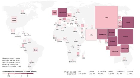
A new analysis of sea levels and flood risk around the world offers more evidence that the brunt of climate change will not be borne equally.
More than a quarter of Vietnam’s residents live in areas likely to be subject to regular floods by the end of the century. Globally, eight of the 10 large countries most at risk are in Asia. These figures are the result of a new analysis of sea levels and flood risk around the world, conducted by Climate Central and based on more detailed sea-level data than has previously been available. The analysis offers more evidence that the countries emitting the most carbon aren’t necessarily the ones that will bear the brunt of climate change.
In this article the author discusses the risk of flooding in many different locations of the world. He claims about 2.6 percent of the world's populations. That's a big percentage considering all the people of the planet.
Flooding is a major risk when it comes to the world we live in especially for Southeast Asia, some areas will be below sea level which shows how the the climate changes are affecting the flood risks caused by global carbon emission. A study from this article shows that eight our of ten of the largest countries will be at the risk of being flooded and below sea level. The major question is how can this carbon emissions be lower? If the carbon is lower then the sea level will rise and less countries will be at risk, this is mainly focusing on Southeast Asia. Yes, we can not change the climate changes but by keeping the land clean and taking care of the environment the flood risk and sea level change could get out of risk level.
If the weather continues at the rate it is at then about 2.6 percent of the global population which is approximately 177 million people will be living in a place at risk of regular flooding. Flooding can cause a lot of damage to homes, crops and people physically because flooding is not just a little amount of water.
The largest country at risk with people in danger from the map is China, I liked the way this map worked because you can see from the boxes how many people are going to be affected by the flooding. Instead of just having numbers, giving a better visual for people with the boxes and their sizes.
It's like watching the land on Earth change right in front of our eyes. According to this map, if global carbon emissions stay as they currently are and sea levels can be affected about as much as expected, 2.6 million people of the global population will live in a high risk flood zone; this wipes out 177 million people!
The worst Hurricane that I remember is Hurricane "Katrina" in 2005. I was living in Puerto Rico but I remember seen the devastating news. The largest number of deaths occurred in New Orleans, which was flooded because its levee system failed. Also "Katrina" was the hurricane that has caused more economic damage as well as one of the five deadliest hurricanes, in the history of the United States. It was a very sad event. I hope that does not happen again.
My father is actually good friends with a guy who he went to school with that specifically help clean up after natural disasters such as hurricanes. I got to talk to him for a little bit about hurricane Katrina, since that was his most recent natural disaster that he helped with at the time. He said it was probably one of the, if not the worst of the natural disaster to help clean and rebuild. He spent the most time with that natural disaster than any others he said. From de-flooding homes, to destroying homes, to rebuilding homes was one of the most strenuous things he has ever had to do in his career.
To get content containing either thought or leadership enter:
To get content containing both thought and leadership enter:
To get content containing the expression thought leadership enter:
You can enter several keywords and you can refine them whenever you want. Our suggestion engine uses more signals but entering a few keywords here will rapidly give you great content to curate.


 Your new post is loading...