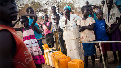
Hundreds of thousands of refugees have fled the civil war in South Sudan and resettled in Uganda. This 12-minute documentary shows the daily struggle to get water.
The multiple catastrophes occurring in Central Africa at the moment are among the worst in recorded history. These traumatized people need to be heard, understood, and helped.
Hundreds of thousands of refugees have fled South Sudan to escape the civil war. When they arrive in Uganda, water is what they need most. Without it, they will die.
Next to nothing in this video will make you happy about the way things operate for refugees in Northern Uganda who have fled from South Sudan. We all know the about the dire conditions that refugees face, but knowing about the specifics, and hearing stories from the refugees about their lives and living conditions is powerful. A huge influx of refugees can tax local resources, especially water. Food can be shipped in, but water a much more locally variable resource. The UN refugee camps recommend at least 15 liters of water per person be made available each day, but often it is more like 4-8 liters in these camps. Dedicated wells (or boreholes) are more effective, but costly. Trucking in water from the Nile River is the preferred method to simply keep these drowning people’s heads above water.
Questions to Ponder: Consider how much water you drink, use for cooking, bathing, etc. per day in your household. How difficult would it be to live on 4 liters of water a day? What about your lifestyle would be changed?
A costly plan to build floating islands shows how climate change is pushing the search for innovative solutions, but some critics ask who will ultimately benefit.
Most of the 1,000 or so Marshall Islands, spread out over 29 narrow coral atolls in the South Pacific, are less than six feet above sea level — and few are more than a mile wide. For the Marshallese, the destructive power of the rising seas is already an inescapable part of daily life. Changing global trade winds have raised sea levels in the South Pacific about a foot over the past 30 years, faster than elsewhere. Scientists are studying whether those changing trade winds have anything to do with climate change.
This post shows how climate change is currently impacting small island nations such as the Marshall Islands. Pacific Sea waters are rising and driving families out of their homes. It is changing the entire physical geography of the land. It is also changing the political climate between different nations as the battle over climate control continues and countries react in different ways to ideas and suggestions, or even laws stating nations like the United States would have to pay money to help those other countries being flooded.
Catastrophic property destruction from sea level rising is (at this point in time) inevitable. A number of Islands that serve as homes for hundreds of thousands of people will be devastated and most likely destroyed. These spots will become uninhabitable and dangerous. The Marshall Islands is just one area that will suffer this fate. Trying to save the islands is a moot point. What is now needed is a discussion about ethics and fiscal responsibility. Industrialized and developed nations led the way in destroying parts of the planet and should be held accountable. To become wealthy, these affluent nations collectively sacrificed the world's fragile environment. With this understanding, people of the Marshall Islands should be given a new home and compensation for their losses. Fortunately, the United States has a deal with the Marshall Islands to allow people to immigrate to the U.S. While this is a good start, these people will require job training, education, homes, transportation, and funds to rebuild their lives. Instead of spending massive amounts of tax dollars on military and defense budgets, Congress needs to reassess its values and priorities. By committing to ethical and noble leadership, the U.S. will have more international prestige and leverage to build defense coalitions and negotiate through diplomatic means. An immense single-nation military-industrial complex will be less relevant. By reducing military spending, this country can address problems like the sinking Marshall Islands and our nation's energy needs. How would it look if the U.S. became a true champion of justice and a despotic nation like China attacked the U.S.? The world would be outraged. The U.N. would condemn the aggressor. Alliances could step forward, allowing America to step back as the world police officer which no one ever asked us to be.
Islands are already at a disadvantage of losing land for a few reasons. First the fact that the older the island gets the more corroding that takes place under the sea. Another reason is they are in the middle of no where so relocation is not easy, costly and not many countries these days are willing to take people in. The Marshall islands like I am sure many other islands are facing in recent years is global warming causing sea levels to rise. So know they have another reason to worry about losing lands. The global warming that takes place on earth never effects the contributors, it almost always effects the little guys who cannot doing anything to fight back. They just get to watch there homes be destroyed because of big time nations. More attention needs to be brought to the subject of global warming and everything and one who is negatively effected by it. What if we were in there shoes, we surely would change our ways then.
Hidden beneath the 245,000 square miles that make up the Great Plains, resides a lake that’s one of our greatest water assets: The Ogallala Aquifer. Haven’t heard of it? Farming the plains would be unprofitable at best without it, as shown by the Dust Bowl of the 1930s. At the time, the aquifer’s existence was known, but the technology to tap into it wasn’t.
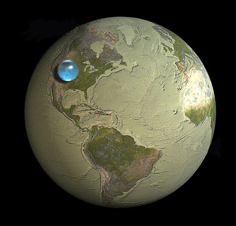
If All of Earth's Water was put into Single Sphere, from the USGS Water Science School...
"This picture shows the size of a sphere that would contain all of Earth's water in comparison to the size of the Earth. The blue sphere sitting on the United States, reaching from about Salt Lake City, Utah to Topeka, Kansas, has a diameter of about 860 miles (about 1,385 kilometers) , with a volume of about 332,500,000 cubic miles (1,386,000,000 cubic kilometers). The sphere includes all the water in the oceans, seas, ice caps, lakes and rivers as well as groundwater, atmospheric water, and even the water in you, your dog, and your tomato plant."
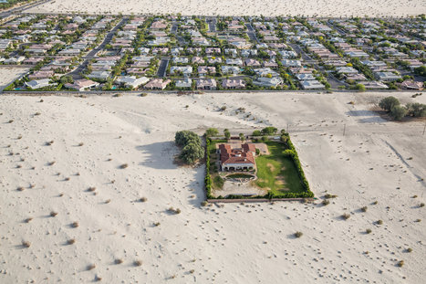
The sunny state of California does in fact get enough rain fall each year but because storm sewers were built after continuous flooding, all of this rainfall is pushed into the Pacific Ocean rather than where it it needed now.
A solution to the insane drought taking California by storm is to use simple rain barrels to collect water at a typical home and a graded lawn to capture and retain water, allowing it to seep into the ground rather than run off into the streets and eventually into the ocean.
The article relates to irrigation and the conservation efforts discussed in Unit 5. Irrigation has a lot to do with the drought in California because massive amounts of water are being used for agriculture in California, which consists of water-needy fruits and vegetables. There are efforts to try to conserve water by installing rainwater collectors to reuse water instead of just draining usable rainwater to the ocean and rivers. There have also been installations of grey water pipes to reuse for irrigation. Grey water is any water that is flushed down the drain that isn't sewage, such as water from showers or water from washing machines. This way water wouldn't have to be wasted and can be reused.
"Pristine Seas is an exploration, research, and media project to find, survey, and help protect the last wild places in the ocean. These pristine places are unknown by all but long-distance fishing fleets, which have started to encroach on them. It is essential that we let the world know that these places exist, that they are threatened, and that they deserve to be protected. Learn more about Pristine Seas here: http://ocean.nationalgeographic.com/ocean/explore/pristine-seas/ "
Fishing and Urban Development have detrimentally destroyed our oceans, and we have polluted the seas at such a high level. Urban growth and over fishing have caused our oceans to be polluted, and we are killing the diversity in Earth's waters. It is essential that we preserve marine life and stop polluting the ocean and the creatures that inhabit it.
Weather is one of the most tangible ways in which the physical environment impacts society. We depend on sunlight and rainfall, we adapt our behaviors to harsh conditions and we are constantly modifying the our environments by heating and cooling our buildings. This Henry David Thoreau quote reminds us to acknowledge the powerful influence of the environment and to recognize that technological fixes have their limitations. “Live in each season as it passes...and resign yourself to the influence of the earth.” --Henry David Thoreau
Question to Ponder: In what ways does the weather shape and influence culture and spatial patterns in your region? How can we make our communities more handicap accessible during winter storms and other extreme conditions?
Human/Environment Interaction is one of the principles of Geography. Weather is about the simplest form of Human/Environment action there is. Weather and climate effect humans in may ways. Both of these have direct impact on agriculture and because of this the rise of civilization in the fertile crescent. But weather doesn't just dictate the rise of agriculture and civilization it effects us everyday. The picture shows Boston covered in record breaking snow fall. This altered many peoples schedules, closed businesses, canceled sporting events, forced people to spend time shoveling snow, gave work for snow plowers, and all in all effected the entirety of Boston.
"Though uninhabited and full of melting ice caps, the Arctic is surprisingly an appealing piece of real estate. Many countries have already claimed parts of the region. So who technically owns the North Pole? And why do these nations want it so bad?"
The video discusses a big topic in discussion today - Who really owns the North Pole? Although the North Pole is uninhabited, many countries have claimed to take ownership of the vast majority of land (or, ice). Canada has already claimed that the North Pole is part of its nation. Russia has put up Russian flags on the North Pole (such as underwater) but does that really make North Pole a Russian territory? The media plays a role in this by offering different opinions on who should and who deserves the right to own the North Pole. You might read a Canadian article that lists all the outright reasons why the North Pole is or deserves to be a Canadian territory.
In my opinion, I don't understand how the United nations can be seen as an entity that, essentially, controls who would have rights to a place like the North Pole(technically, not owned by anyone). I, naively, understand the basics of the U.N. In short, it is an organization that was formed, post-WW I or II, as a governing board for world-issues.
With that being said, how can they believe that their "law" is the all-powerful one? If I'm a leader of a country who is not a member of the U.N., do I really care what they say? I just find it odd that this narrator speaks about the issue while holding the U.N. as a supreme authority. I know that this video is just a quick fun type of video but it leaves me with wanting to hear the perspective of a non-U.N. member. But a very interesting topic, none the less.
Editor's note: This story is one in a series on a crisis in America's Breadbasket –the depletion of the Ogallala Aquifer and its effects on a region that hel...
I used to teach students about the surprising water crises in central and SE Wisconsin, one of the most water-rich states in the US. They were always blown away. Now, teaching in CO, everyone seems to have an awareness (anxiety?) about local water scarcity. This story, though, has more of a national, even global scope.
Thanks to my good friend, Seth Dixon for the original scoop. There had been quite a bit of news reporting on the drought in central California this year, but this midwestern region has been experiencing water stress for years with little national attention. I plan to use this article in both an upcoming presentation as well as an example when I teach "Tragedy of the Commons" in my Environmental Dilemma class.
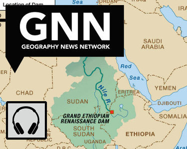
"Ethiopia is three years from completing a dam to control its headwaters, and while Egypt points to colonial-era treaties to claim the water and to stop the project, the question remains as to who own the Blue Nile."
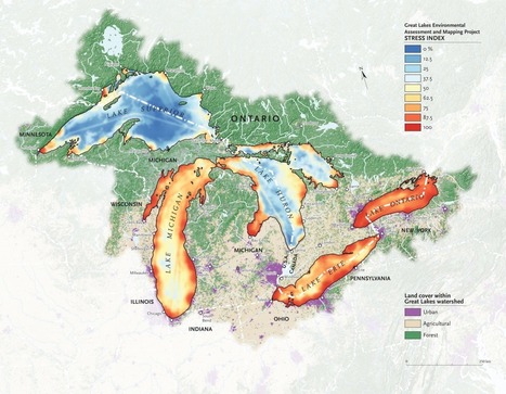
"It’s no secret that the Great Lakes are suffering tremendous ecological strain — Lake Erie was even pronounced “dead” for a time during the 1960s because of an overload of phosphorus from municipal waste. Back in 1615, though, when the entire region was pristine and explorers Samuel de Champlain and Étienne Brûlé gazed out together from Lake Huron’s shores, they dubbed it la mer douce, 'the sweet sea.' Today roughly one-quarter of Canada’s population and a 10th of America’s population drink from the Great Lakes basin; the beleaguered lakes alone hold more than a fifth of Earth’s freshwater."
It is amazing, in a sad way, to see how in just four centuries these lakes have gone from "la mer douce" to "dead." This map is a reminder of the damage humans do to the environment on a daily basis, and of the importance of protecting our natural resources. Considering the fact that these lakes hold roughly one fifth of all of the fresh water on the planet and provide drinking water for millions of people in both the U.S. and Canada, we need to think about the impact we have on the world around us and how that impact can come back to bite us on the rear end.
Today, to the southeast of Block Island, there are five new structures rising from the ocean. These are the towers of the Block Island Wind Farm (BIWF), the first offshore wind energy installation in the United States. The turbines will generate 30 megawatts of energy; providing electricity to 17,000 households on Block Island and coastal Rhode Island (McCann, 2016), and replacing the diesel generators that previously powered New Shoreham. The turbines are on schedule to begin turning in November 2016 once commissioning is complete.
Global warming has raised global sea level about 8" since 1880, and the rate of rise is accelerating. Rising seas dramatically increase the odds of damaging floods from storm surges.
While researching a book on ‘Why the Dutch are Different’, Ben Coates realised that an amazingly large number of the things which an outsider might think of as ‘typically Dutch’ could be explained at least in part by a single factor: water.
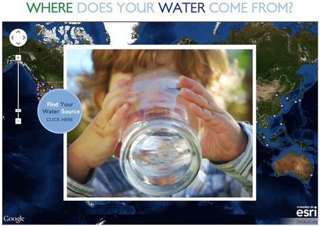
This interactive map documents where 443 million people around the world get there water (although the United States data is by far the most extensive). Most people can't answer this question. A recent poll by The Nature Conservancy discoverd that 77% of Americans (not on private well water) don't know where their water comes from, they just drink it. This link has videos, infographics and suggestions to promote cleaner water. This is also a fabulous example of an embedded map using ArcGIS Online to share geospatial data with a wider audience.
A punishing drought is forcing a reconsideration of whether the aspiration of untrammeled growth that has for so long been the state’s engine has run against the limits of nature.
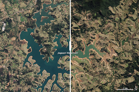
Brazil’s largest city, Sao Paulo, which provides one third of the countries GPD, is now running low or water due to one of the worst droughts in 8 years. There are more than 21 million people in this city and 13 million of them are facing water outages. If it doesn't rain soon, the city could face a collapse. The city has blamed the drought of lack of water in the vapor clouds that the amazon usually provides to the city. They also blame it on deforestation and global warming. President Dilma Rousseff has questioned the cities misusage of their water supply, claiming that the city mismanaged their water supply.
This shows just how important water is the human race. It also shows how humans have no sense of urgency in conserving water until it's too late. The saying "you never know a good thing until it's gone" applies in this case. The Brazilian government did not take any sufficient measures to conserve water until it realized how depleted the reservoir is. This event demonstrates the environmental impact of water depletion on humans, and how humans have such a huge impact on the geographical landscape on Earth. As seen in the picture above, many greens turned yellow as a result of the lowering water levels. The river beds are soon going to be overgrown by shrubbery as water no longer exists there. These are all results of a combination of natural (lack of rain) and human causes of resource depletion.
"The Sahel’s ability to produce food is not keeping pace with its growing population, and global warming will only exacerbate the imbalance, according to a new study. Among the 22 countries making up the arid region in northern Africa, the population grew to 471 million in 2010 from 367 million in 2000, a jump of nearly 30%. As the population grew rapidly, the production of crops remained essentially unchanged. Using satellite images to calculate annual crop production in the conflict-ridden Sahel belt, south of the Sahara desert, the researchers then compared output with population growth and food and fuel consumption."
If a country has a big population growth, the resources that it has if they are already scarce may become devastating. As the population of Sahel does increase, the amount of food resources will not have the proper time to react to the growth. Granted it may take a while for agricultural crops to grow and many citizens may face hard times facing finding food, but their hardships will be overcome by farmers trying to produce more crops to help ease that hardship.
this seems like an alarmingly common problem in the world today with population growth happening at an alarming rate in many parts of the world. most notably india and china. as well as in sahel, if your population grows by 100 million in 10 years it will be impossible to keep up and be able to provide for that many people in such a reletively short time.
Also known as the African Transition Zone, this region is one of the harshest areas on the planet. So it is no wonder that the Sahel is having trouble feeding the population influx. It is a very Arid climate making food production difficult if lacking the technology to make this desert terrain work, which the Sahel does lack. The global warming that is taking is also going to have a terrible effect on the Sahel if there population trends continue. They need help, mostly how to make this area sustainable for the people that live here.
Canada has dispatched two icebreakers to map the Arctic seabed beneath the North Pole to support a bid to extend the country's maritime territory deeper into the waterways at the top of the world.
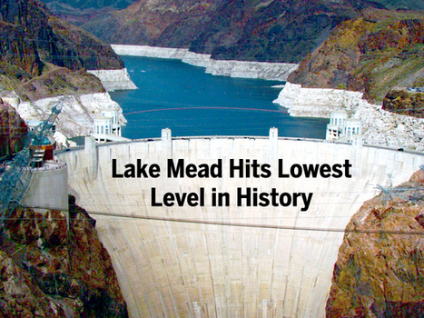
"The largest reservoir in the U.S. falls to its lowest water level in history, Nevada State Sen. Tick Segerblom introduced a bill title and issued a press release on July 8 calling for an 'independent scientific and economic audit of the Bureau of Reclamation’s strategies for Colorado River management.'"
This week’s history-making, bad-news event at Lake Mead has already triggered lots of news stories, but almost all of these stories focus on the water supply for Las Vegas, Phoenix and California. But what about the health of the river itself?
Many geographers are aware that future water resource issues in the American Southwest will have political, cultural, and social impacts. What do you believe to be some approaching concerns after reading this article?
To get content containing either thought or leadership enter:
To get content containing both thought and leadership enter:
To get content containing the expression thought leadership enter:
You can enter several keywords and you can refine them whenever you want. Our suggestion engine uses more signals but entering a few keywords here will rapidly give you great content to curate.


 Your new post is loading...