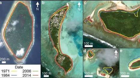
"The tiny Pacific nation of Tuvalu – once thought to be under threat from rising sea levels – has grown the size of California's Disneyland over the past 40 years. It's mostly thanks to waves dumping extra sediment, sand and gravel on shore lines, according to research by Auckland University scientists. The study, published in the Nature Communications journal on Friday, was the first in-depth look at how much each of Tuvalu's 101 islands have changed over the decades."
This article was about the whale and how they were repopulating and how the whale hunting was banned in the 70s. I think this article was really good because use it talked about whales.
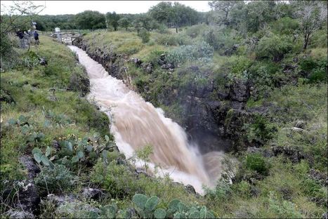
At this sinkhole, about 500 cubic feet of water per second is disappearing into the earth, the equivalent of an Olympic-sized swimming pool every three minutes, according to an engineer with the Edwards Aquifer Authority. For as much water reaches the aquifer at this spot, far more infiltrates through porous rock across South-central Texas.
"How deep is that icy blue water on Greenland's ice sheet? Dr. Allen Pope, of the National Snow and Ice Data Center, is using data from the NASA/USGS Landsat 8 satellite to find out. In this video, Dr. Pope shares what he sees when he looks at a Landsat image of the Greenland ice sheet just south of the Jakobshavn Glacier.
Because the lakes are darker than the ice around them, they absorb more energy from the sun. A little bit of melt concentrates in one place, and then melts more, establishing a feedback mechanism accelerating the growth of the lake. When the lakes get big enough they can force open fractures that then drill all the way down to the bed of the glacier, transporting this water to the base where it can temporarily speed up the flow of the ice."
this was interesting mother nature shows us once again that she is in control by showing us how easily our seemingly strong structures can be swept away
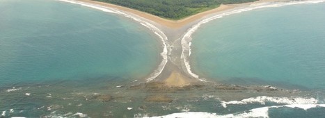
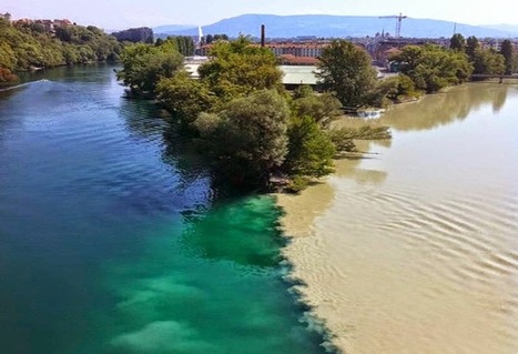
"Confluences occur wherever two streams come together. If the gradient is low (i.e., nearly level) and the properties of the two streams are very different, the confluences may be characterized by a dramatic visible distinction as the mixing occurs only slowly."
So pretty much, the water controls rivers rather than particles controlling the river. Also, it appears that the motion and strength of the water causes rivers to bend and form in different curves. I'd like to think of it as a ball bouncing from side to side and every time it touches the border land of a river, it expands to the opposite side. However, when the water flow is hitting the side of a river, the opposite side is not getting any force from the water flow. In that case, the side that is not getting hit by the water flow slowly moves to the side that is being by the water flow causing river curves.
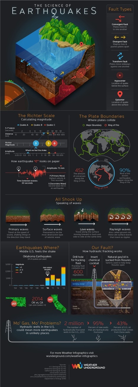
From fault types to the Ring of Fire to hydraulic fracking, the Earthquakes infographic by Weather Underground helps us understand the complexities of what shakes the ground.
"The edge of the 4,000 square foot residence on Overlook Court was dangling about 75 feet above the rocky shoreline of Lake Whitney after part it it had already broken off."
"On May 28, 2008, Adam LeWinter and Director Jeff Orlowski filmed a historic breakup at the Ilulissat Glacier in Western Greenland. The calving event lasted for 75 minutes and the glacier retreated a full mile across a calving face three miles wide. The height of the ice is about 3,000 feet, 300-400 feet above water and the rest below water."
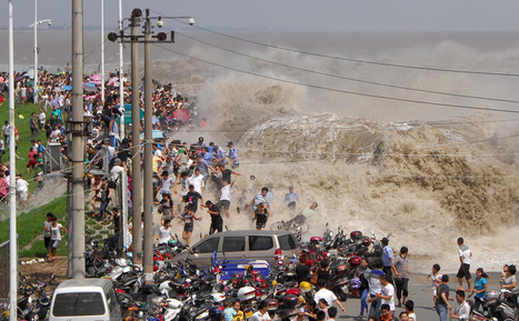
For hundreds of years, on the eighth month of the lunar calendar, people have gathered along the shores of China’s Qiantang River at the head of Hangzhou Bay to witness the waves of its famous bore tide. Higher-than-normal high tides push into the harbor, funneling into the river, causing a broad wave that can reach up to 30 feet high. If the waves surge over the banks, spectators can be swept up, pushed along walkways or down embankments. Below, I’ve gathered images from the past few years of the Qiantang bore tides.
Death Valley,California - Giant boulders in the desert look as though their moving all on their own! But could weird weather be behind these roving rocks
"The largest earthquake ever recorded by instruments struck southern Chile on May 22, 1960. This 9.5 magnitude earthquake generated a tsunami that crossed the Pacific Ocean, killing as many as 2000 people in Chile and Peru, 61 people in Hilo, Hawaii, and 142 people in Japan as well as causing damage in the Marquesas Islands (Fr. Polynesia), Samoa, New Zealand, Australia, the Philippines, and in Alaska's Aleutian Islands. To see how this tsunami compares with two recent tsunamis from Chile, please watch http://youtu.be/qoxTC3vIF1U "
Tsunami ocurrido en Chile el 22 de Mayo de 1960 donde murieron 2000 personas en Chile y Perú, 61 en Hilo Hawaii, 142 en Japón causando daños en Islas Marquesas Polinesia , Samoa, Nueva Zelanda, Australia, Filipinas, Alaska's Islas Aleutianas.....enlace para ver la comparación con el Tsunamis recientes en Chile (2015)
"Geoscientists have unveiled a computer model that maps the details of that tectonic dance in 1-million-year increments—practically a frame-by-frame recap of geologic time. It shows that the plates speed up, slow down, and move around in unexpectedly short bursts of activity. It also suggests that researchers may have to rethink what drives much of that incessant motion. The new model shows that although plates usually creep along at an average speed of about 4 centimeters per year, some can reach much faster speeds in short sprints. For example, India, which broke off the east coast of Africa about 120 million years and is now plowing into Asia, reached speeds as high as 20 centimeters per year for a relatively brief 10 million years."
"Los geocientíficos han dado a conocer un modelo de computadora que asigna los detalles de esa danza tectónico en 1 millón de años incrementos de una recapitulación fotograma a fotograma de tiempo geológico. Esto demuestra que las placas aceleran, frenan, y se mueven alrededor de pequeños estallidos de actividad. también sugiere que los investigadores pueden tener que repensar lo que impulsa gran parte de ese movimiento incesante. El nuevo modelo muestra que, aunque por lo general se arrastran a lo largo de las placas a una velocidad media de unos 4 centímetros por año, algunos pueden alcanzar velocidades mucho más rápidas en carreras cortas. Por ejemplo, la India, que estalló frente a la costa oriental de África a unos 120 millones de años y ahora está arando en Asia, alcanza velocidades de hasta 20 centímetros por año durante un tiempo relativamente breves 10 millones años ".
This seems like a useful tool to a degree. But if we could actually simulate every destructive event then we would be miracle workers. This was a sad event. We have left such an imprint on the earth that it's starting to fight back. We need to be more aware and careful with the one planet we have. Climate changes are in the news more and more. We can't ignore climate changes anymore.
"The signs that something’s wrong are not immediately obvious, but, once you see them, it’s hard to tune them out. Curbs at nearly the exact same spot on opposite sides of the street are popped out of alignment. Houses too young to show this kind of wear stand oddly warped, torqued out of sync with their own foundations, their once-strong frames off-kilter. This is Hollister, California, a town being broken in two slowly, relentlessly, and in real time by an effect known as 'fault creep.' A slow, surreal tide of deformation has appeared throughout the city."
El Sire Reserve in Peru is a river that has been monitored over the last 28 years. Every time I watch this short 6 second clip, I learn something different about how this river has changed. On the bottom of the screen, just past half way, the river just takes a huge short cut and cuts over and connects to a different part of the same river. This happens on the whole river too. there are 8 or 9 huge bends and curves in the river but by the end in 2012 there are only about 3 to 4 bends and curves. For some reason the water is taking short cuts and just leaving the spaces where the water used to run through and leaving it dry.
It's amazing to see that even though we have been on this planet for so long, there are stilll mysteries such as this. Tjis could have taken year s to solve but looking at the picture in the slides at the bottom of the article, it seems like this group of scientists knew exactly how to figure this out. this all happens becasue of geography and where these rocks are in the world that make them move around. Iis in a dried up lake pond that freezes over at night to create a layer of ice strong enough to help the rocks move around at night. This discovery took 2 whole years to figure out, but was vey much worth it in the end.
"A block-long sinkhole opened up in a residential neighborhood in rain-soaked Baltimore on Wednesday, devouring cars and forcing the evacuation of several houses."
To get content containing either thought or leadership enter:
To get content containing both thought and leadership enter:
To get content containing the expression thought leadership enter:
You can enter several keywords and you can refine them whenever you want. Our suggestion engine uses more signals but entering a few keywords here will rapidly give you great content to curate.


 Your new post is loading...