


The 48 contiguous states alone are a 1.9 billion-acre jigsaw puzzle of cities, farms, forests and pastures.
Get Started for FREE
Sign up with Facebook Sign up with X
I don't have a Facebook or a X account


 Your new post is loading...
 Your new post is loading...
Your new post is loading...
The 48 contiguous states alone are a 1.9 billion-acre jigsaw puzzle of cities, farms, forests and pastures. 
"For generations we vultures, armed with our senses, have fought in silence. We’ve waged a battle against garbage, but now we’re losing that battle. We want to help humans, so we’ve launched a movement to help you detect piles of garbage so that you can take action to eliminate them. Join us in this fight. Vultures Warn, you take action!" Via Mike Busarello's Digital Storybooks

Kelvis Hernandez's curator insight,
September 29, 2018 11:00 PM
An ingenious idea to clean up the environment. This group is based out of Lima, Peru uses the vultures in the city to find the piles of garbage and refuse left by people and set up events to clean up the area. It is an amazing way to utilize nature to help us solve the problems we caused ourselves. They utilize the vultures by putting GPS devices and GoPro cameras on them and wait until they locate large trash piles. The video itself is so well-made and interesting that it almost forces you to learn more by checking out their website and their social media pages. The phrase they use is "Gallinazo Avisa, Tu Actuas" translates to vultures warn, you act. 1

Benjamin Jackson's curator insight,
November 9, 2015 5:40 PM
The impact of the Three Gorges Dam on the residents upstream is amazing. I cannot imagine anything like this happening in the US, mostly because of the impact on the people both upstream and downstream. Ecological damage from this dam may not phase the Chinese government, but I think any North American or European government would shudder at the thought of the backlash among their citizens this would create. 
Matt Ramsdell's curator insight,
December 14, 2015 9:27 PM
Three Gorges damn in China is the largest dam ever constructed. This was created to save on power by creating hydroelectric power for the people of the land. One of the issues with this was the the flooding of the land up streams displacing millions of people. It created a larger up stream area and very small down stream. A lot of the people that lived up stream had to be relocated further inland and faced changing climatif weather. The banks of the river are carved out between what seems like mountainous regions so as you move more uphill the weather and temperature will be a whole new category of life (Depending on how far you relocated). 
Stevie-Rae Wood's curator insight,
December 9, 2018 6:09 PM
From the animation that NASA has created of the construction of the Three Gorges Dam it is apparent that land has been lost. The Three Gorges Dam was created to generate more energy for Chinas growing economy. It is known as the largest hydroelectric project ever costing around 40 billion dollars and requiring 20,000 workers. There is a good and bad side to the creation of this dam. It has helped Chinas economy grow however to the expense of the people that were displaced because the dam took away land as we can see In the animation. It also effected people downstream negatively as we can see as well because there water supply was depleted. Like most things that take place today the people that benefit from something usually live far away from the problem while those that live closest pay the more costly price.
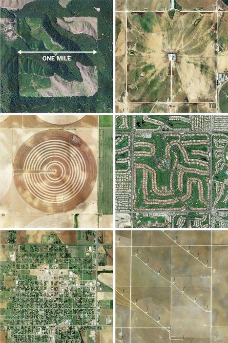
"The images here, taken from the Instagram account @the.jefferson.grid show just a few of the landscapes that can be squeezed into the one-mile squares. The idea behind this sprawling checkerboard emerged after the Revolutionary War. As the United States expanded westward, the country needed a systematic way to divide its newly acquired lands. The original colonies were surveyed using the British system of 'metes and bounds,' with parcels delineated using local geography.
That approach doesn’t scale very well, and Jefferson proposed to slice the young United States into gridded plots of land. Jefferson's idea became a reality in 1785 when it was enacted as the Public Land Survey System. Today his grid covers much of the country, and it is still used to survey federal lands — an idea that shaped the physical landscape of half a continent."
Tags: images, land use, landscape, social media, planning, spatial, scale, historical. Via Mike Busarello's Digital Storybooks

Dyna-e International's curator insight,
September 1, 2015 12:32 PM
No such thing as being off the grid really. ~ Ron Sandack

"Lake Urmia in northwestern Iran was once one of the largest saltwater lakes in the Middle East, but it has diminished dramatically. Diversion of water from local rivers for agricultural use is one likely cause. Since 1996, drought has further contributed to the decline. The lake now covers about 10 percent of the area it covered in the 1970s. In the 2014 image, the entire southern portion of the salty lakebed is exposed. Also see this set of images." Tags: Iran, remote sensing, geospatial, unit 1 Geoprinciples, land use, food, food production, environment.
History (and sometimes, unfortunately, current events) shows us just how easily national borders can change, but we still like to think that they are permanent fixtures. These photos of different national borders around the world show you how both friendly and hostile nations like to fence off their turf.
This is hard to believe, but it is true. They have it down to a science.

Canada is a massive country, yet it has one of the lowest population densities in the world. Despite this, Canadians have made a wide impact on their land, much of it visible from aerial and satellite photography. Hydroelectric facilities, roads, mines, farms, ports, resource exploration, logging, canals, cities, and towns have altered much of the landscape over the years.

Michael Amberg's curator insight,
May 26, 2015 11:28 PM
This shows how even small populations can make a big impact on the world from the changes in urbanization.
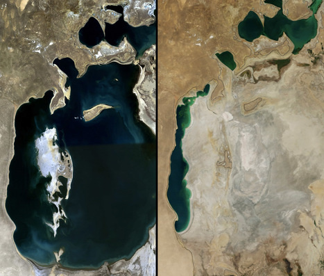
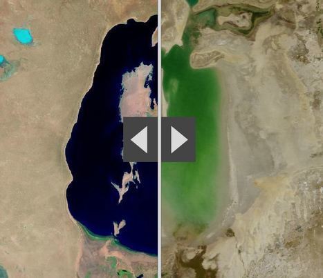
"Once the fourth-largest lake in the world, Central Asia's shrinking Aral Sea has reached a new low, thanks to decades-old water diversions and a more recent drought."

Kelsey McIntosh's curator insight,
March 31, 2018 2:28 PM
This article briefly discusses the disappearing Aral Sea. Once being the fourth largest lake, evaporation and water diversions have caused it to shrink significantly. Because the sea has always been salty, the disappearing water has caused the salt content to rise and has made the water practically unusable.

brielle blais's curator insight,
April 1, 2018 3:28 PM
This post showcases physical geography. The Aral Sea is dissipating, and it is leaving behind tons and tons of salt. This salt is affecting the local agriculture, such as in Kazakhstan and Uzbekistan, where the crops that are irrigated are suffering from the high salt levels.
Kelvis Hernandez's curator insight,
November 1, 2018 8:02 PM
Once one of the largest lakes in the world, the Aral Sea in Central Asia has been progressively shrinking due to recent droughts and water diversions happening over decades. With the whole eastern section of the lake gone, all that's left is the salt and heavy minerals that will eventually make its way into the air causing different problems for people in the surrounding area.
"A 3-minute journey through the last 250 years of our history, from the start of the Industrial Revolution to the Rio+20 Summit. The film charts the growth of humanity into a global force on the equivalent scale to major geological processes."

Courtney Barrowman's curator insight,
May 21, 2015 11:33 AM
Summer reading KQ1: How has the Earth's environment changed over time? 
Alex Smiga's curator insight,
March 14, 2016 7:44 PM
Many geologists and other scientists now recognize that we are in a new geologic era. This new era, called the Anthropocene, is distinguished by the fact that one species (homo sapiens), is dramatically modifying the environment. These modifications are impacting geologic processes to such a degree that this time period is geologically distinct (see this remote sensing interactive for examples of environmental change). Paul Crutzen, a Nobel Prize–winning scientist who champions the term Anthropocene declared, “It’s no longer us against ‘Nature.’ Instead, it’s we who decide what nature is and what it will be.” This video is a great primer for discussing the nature and extent of human and environmental interactions as related to industrialization, globalization and climate change. This is definitely one of my favorite resources.
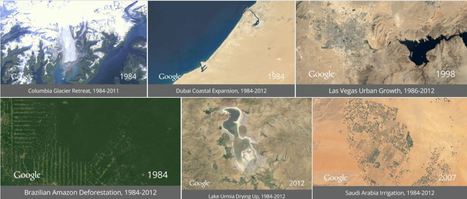
"It took the folks at Google to upgrade these choppy visual sequences from crude flip-book quality to true video footage. With the help of massive amounts of computer muscle, they have scrubbed away cloud cover, filled in missing pixels, digitally stitched puzzle-piece pictures together, until the growing, thriving, sometimes dying planet is revealed in all its dynamic churn. The images are striking not just because of their vast sweep of geography and time but also because of their staggering detail."

Sally Egan's curator insight,
August 26, 2014 6:42 PM
This is a great demonstration of human impacts on ecosystems. 7 locations in the world show dramatic change over time. |

"This case study considers the pros and cons of cotton production in Uzbekistan. Since the country's independence from the Soviet Union in 1991, revenues from cotton taxation have contributed substantially to developing the industrial sector, boosting the current account, achieving energy and food-grain self-sufficiency, and buffering domestic shocks in food and energy prices. Nonetheless, some argue that the state procurement system hampers the development of the agricultural sector. Often the payments for cotton hardly cover farmers' production costs, and the quasi mono-culture of cotton production has adversely affected environmental sustainability." Via Alexandra Piggott

Did you hear about the Five Pillars of the British Landscaping Empire during your religion classes? To sort them by order of importance within the Holy Book of Grass: First is grass. Second is past...
Skuuppilehdet's insight:
I've written in the past about the aesthetics of the an ideal British landscape (as embodied in the anthem Jerusalem). The British ideal was to tame nature; the Canadians on the other hand, embraced the wildness of the natural landscape. Those difference normative views of landscape helped to shape national identity and inform land use decision-making processes.

Leonardo Wild's curator insight,
March 1, 2016 2:07 PM
I've written in the past about the aesthetics of the an ideal British landscape (as embodied in the anthem Jerusalem). The British ideal was to tame nature; the Canadians on the other hand, embraced the wildness of the natural landscape. Those difference normative views of landscape helped to shape national identity and inform land use decision-making processes. Tags: UK, landscape, culture, Canada, land use.
"By moving the slider, the user can compare 1990 false-color Landsat views (left) with recent true-color imagery (right). Humans are increasingly transforming Earth’s surface—through direct activities such as farming, mining, and building, and indirectly by altering its climate."

James Piccolino's curator insight,
March 24, 2018 9:46 AM
Wow. This is depressing. I knew of the Aral sea thanks to class, but the others I had no idea. They were so green and lush way back in the day. Now they are dead and seriously in a sad state. There is nothing wrong with development and advancement, but this is just a lot when it comes to impact.

othni lindor's curator insight,
October 20, 2018 4:01 AM
This map shows how human activities like farming has shaped the Earth's surface. The example they show is the Aral Sea. It is a
regional environmental problem. It is located between the Southern part of Kazakhstan and Northern Uzbekistan. It used to be the world's fourth largest saline lake. Human activities have caused the lake to be almost completely dried up. Over the years, the Aral Sea became polluted with pesticides and chemicals.
Stevie-Rae Wood's curator insight,
October 28, 2018 9:51 PM
The Aral Sea is a severe environmental issue in Central Asia. This map that we are looking at shows how human activities such as farming have destroyed a natural wonder. The Aral Sea USED to be the fourth largest saline lake but has dried up. The Aral Sea has five times less volume and is five times more saltier than it once was. This occurred because people surrounding the area used more water and used it more intensely. The soviets thought it would be a good idea to use more water projects such as planting cotton, and rice which are water intense crops. This severely dried up the Sea. The area that the sea once was that is now dry land in uninhabitable because of the levels of salt left behind. As well the rivers that connected to the Aral Sea have either dried out or are on the verge of drying out causing many economic problems for those that depended on that water.
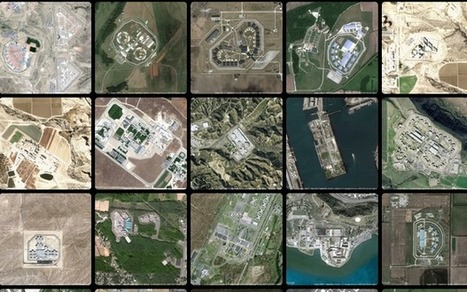
America has more than 5,000 prisons. This is what they look like on our landscape.
Begley’s images capture the massive scale of this entire industry and the land that we devote to it (America has less than 5 percent of the world’s population but houses a quarter of the world’s prisoners). His website, in fact, includes only about 14 percent of all of the prisons he’s captured (each one is scaled to the same size).
Tags: remote sensing, land use, geospatial, landscape. Via Dawn Haas Tache

Bob Beaven's curator insight,
January 29, 2015 2:27 PM
This article is interesting from a geographic and social perspective, because the overhead pictures show just how much we alter the land with our prisons. What is really interesting is how the US has less than five percent of the world's population but has one quarter of its prisoners. Because of this, it can be inferred that the country has many prisons. Yet, what astonished me about the prisons is that they seem to be out in the middle of nowhere. The buildings seem expansive on the landscape and dominate it. It just makes me wonder, how much does the United States spend on building and up-keeping these complexes. 
Incarceration's curator insight,
May 8, 2015 1:11 AM
This article explores a graphic representation of the quantity and volume of prisons throughout the United States. The project has no figures, statistics, or words - the pictures stand on their own as statements about the growing amount and size of prisons across the country. The photos show many rural prisons that house prisoners from urban areas, which changes both the areas where the prisons are and the areas that the inmates came from.
The photos are an intriguing visual of the money and materials put into prison systems in the United States. The photographer (Josh Begley) noted that upon seeing all the images together, the thing that stood out to him was that there were baseball fields in almost all of them. He says, "the baseball field mimicked the form about these buildings as well. There was something very American about it when I first saw it."
It's surprising to see how much material is necessary to, as the article described it, "warehouse" people. While prisons do more than just house inmates, seeing a visual representation of all the money put into prisons in the United States makes me wonder whether it could be better spent on reformed versions of prisons, rather than on maintaining the ones we already have and the new ones just like those that are currently being constructed.
- K 
Lydia Tsao's curator insight,
May 26, 2015 2:43 AM
These picture demonstrate the power of satellite imagery and technology perfectly. While I am amazed by the sheer beauty in spatial organization and design by these prisons, I am horrified at the maps incarcerations that are occurring in America, especially the mass incarceration of poverty stricken minorities in America. Prisons demonstrate a larger social issue than what I previously thought. I never knew that such a thing as prison-based gerrymandering could even exist. Prisons demonstrate economic and political problems as well. With more prisons, state must allocate more of their budget to supporting these facilities. The fact that so many prisons are being built demonstrate a larger problem in the political world, and that maybe there is an issue with the justice system. Fixing the system would allow for states to allocate more money that would have been use on supporting prisons to supporting education and helping those who are less privileged.

Ambre Cooper's curator insight,
June 25, 2015 4:04 PM
This is a cool little video. It even shows the level of Aral Sea we read about. 
Hamdou Wane's curator insight,
June 29, 2015 7:55 AM
Satellites have been watching us for 40 years. Here's what their images reveal
Alex Smiga's curator insight,
August 6, 2017 8:45 AM
Seth Dixon's insight:
This video is simple entry point into the various applications of remote sensing as well as various human and environmental interactions. This video highlights 5 examples: 1. Deforestation (Brazil) 2. Water Use (Aral Sea) 3. Urban Sprawl (Las Vegas) 4. Energy (Coal in Wyoming) 5. Climate Change (Ice Shelf in Antarctica)

We've dammed mighty rivers, built hundreds of artificial islands, and made the world's fourth-largest lake disappear.
Courtney Barrowman's curator insight,
May 21, 2015 10:02 AM
Summer reading KQ2, How have humans altered Earth's environment? key concepts- remote sensing, land use
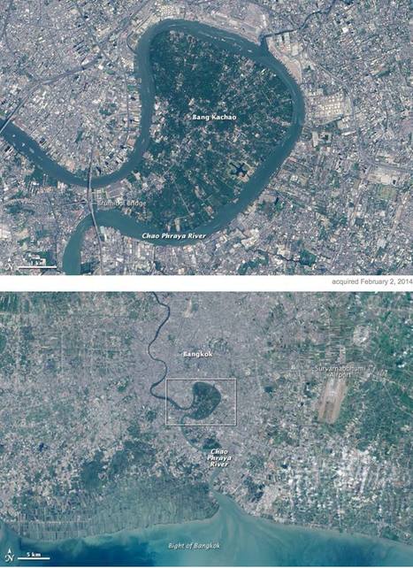
"In the heart of Thailand’s most populous city, an oasis stands out from the urban landscape like a great “green lung.” That’s the nickname given to Bang Kachao—a lush protected area that has escaped the dense development seen elsewhere in Bangkok. The city is built on the alluvial plain of the Chao Phraya River. Toward the southern end, near the Gulf of Thailand, is an old meander that never quite formed an oxbow lake. That meander traces the boundary of Bang Kachao, which TIME magazine once called the 'best urban oasis' in Asia. According to a travel story in The New York Times, Bang Kachao is gaining popularity among tourists lured by bike tours, a floating farmers’ market, and the relaxed atmosphere." Tags: physical, fluvial, remote sensing, land use, Thailand, Southeast Asia, urban ecology. Via GTANSW & ACT

Savannah Rains's curator insight,
May 27, 2015 1:51 AM
This scoop shows an example of built environmental space. The highly urban and crowded Thailand has little green space. So why is this massive green park looking landmass there? Its a strictly environmental section of land to help water flow into the ocean. The people call it the "green lung" because its plants give off oxygen and provide a contrast from its urban sprawl. This article shows the importance that should be placed on having more strictly environmental places in big cities. 
Chris Costa's curator insight,
November 9, 2015 2:06 PM
It's interesting to see the mixture of natural and manmade landscapes in this image. Humans have an enormous influence on the world around us- we have moved entire rivers for our own purposes, reshaped entire regions. In China, we have literally made it rain. Therefore, it's nice to see remnants of the rich environments that used to cover the urban sprawls of many of the world's largest cities, like Central Park in New York. Bang Kachao in Bangkok is another example of this, a reminder of the richness of the region before it was overwhelmed by the urban development that has characterized Bangkok over the previous century. The oasis serves as a valuable tourist attraction, as Westerners come to enjoy the bike trails and small farming community within Thailand's green lung. Leave it to hipsters to travel halfway across the globe just to enjoy nature within the confines of one of the world's largest cities.
brielle blais's curator insight,
May 3, 2018 3:55 PM
This showcases how important physical geography is. This "green lung" breaks up the high urbanized Bangkok. This helps the environment thrive and helps to cut down of emissions that affect climate change which is a problem in some areas.

The last section of dam is being blasted from the Elwha River on Washington's Olympic Peninsula on Tuesday. For almost half a century, the two dams were widely applauded for powering the growth of the peninsula and its primary industry. But the dams blocked salmon migration up the Elwha, devastating its fish and shellfish—and the livelihood of the Lower Elwha Klallam tribe. As the tribe slowly gained political power—it won federal recognition in 1968—it and other tribes began to protest the loss of the fishing rights promised to them by federal treaty in the mid-1800s. In 1979, the U.S. Supreme Court ruled that Washington tribes, including the Elwha Klallam, were entitled to half the salmon catch in the state. Via dilaycock
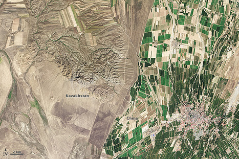
"While people often say that borders aren’t visible from space, the line between Kazakhstan and China could not be more clear in this satellite image. Acquired by the Landsat 8 satellite on September 9, 2013, the image shows northwestern China around the city of Qoqek and far eastern Kazakhstan near Lake Balqash. The border between the two countries is defined by land-use policies. In China, land use is intense. Only 11.62 percent of China’s land is arable. Pressed by a need to produce food for 1.3 billion people, China farms just about any land that can be sustained for agriculture. Fields are dark green in contrast to the surrounding arid landscape, a sign that the agriculture is irrigated. As of 2006, about 65 percent of China’s fresh water was used for agriculture, irrigating 629,000 square kilometers (243,000 square miles) of farmland, an area slightly smaller than the state of Texas. The story is quite different in Kazakhstan. Here, large industrial-sized farms dominate, an artifact of Soviet-era agriculture. While agriculture is an important sector in the Kazakh economy, eastern Kazakhstan is a minor growing area. Only 0.03 percent of Kazakhstan’s land is devoted to permanent agriculture, with 20,660 square kilometers being irrigated. The land along the Chinese border is minimally used, though rectangular shapes show that farming does occur in the region. Much of the agriculture in this region is rain-fed, so the fields are tan much like the surrounding natural landscape." Tags: remote sensing, land use, environment, geospatial, environment modify, food, agriculture, agricultural land change.

Felix Ramos Jr.'s curator insight,
April 15, 2015 10:24 AM
It is amazing what irrigation can produce. The border between China and Kazakhstan is a perfect picture of land with irrigation and one without supplied water. Eastern Kasakhstan has farmland but it is only subsidized by natural rainfall whereas on the greener Chinese side of the border it is supplemented with water by the farmers. Great picture! 
Kevin Cournoyer's curator insight,
May 6, 2015 12:00 PM
Seeing such a striking difference between two countries that are so close together is strange and thought-provoking. Knowing a little bit about the two countries can make a world of difference, though. In this case, we have China and Kazakhstan, two countries located in East/Central Asia. Kazakhstan borders China to the west, along the northern part of its western border. Much of China's inland land use is devoted to agriculture, as the majority of its industry is located near its coast. This is evident by the amount of green space seen in the satellite image above. With well over a billion people to feed, China needs to make use of as much of its arable land as possible. Kazakhstan, on the other hand is a much smaller country with much less land devoted to agriculture. Its farmland is mostly large and industrial, as a result of Soviet-era farming and is rain-fed rather than irrigated, like China's.
Knowing the history as well as the economic strengths of a country can therefore be useful in interpreting satellite images such as the one in this article. A lack of knowledge about China and Kazakhstan's economy and history may lead to an assumption that the Chinese are just better farmers than the Kazakhs. This is of course not necessarily true, but what is true is that China has a much larger and more immediate need for agriculture than does Kazakhstan and so devotes more of its land, time, and energy to farming. Likewise, it shouldn't be assumed that Kazakhstan has no need for agriculture at all. Instead, its history has largely influenced its economic strengths and needs, and the result is a country that looks very different from China.
Chris Costa's curator insight,
October 19, 2015 12:41 PM
It's crazy to see how much human influences can reshape the landscape, or how things we tend to think of in more abstract terms- like national boundaries- can be very physical in nature. I liked reading about the differing agricultural approaches the two nations take, and being able to see the physical manifestations of those two different approaches so obviously. It's impressive to think that China is able to support such a massive population- one in every 5 people alive on the planet is Chinese- with so little land, and the consequences are plain to see in the image above. Increased irrigation efforts leads to the unnaturally bright green patches in the middle of a relatively dry area, serving as a symbol of man's attempts to bind mother nature to his will. Although not always successful, such attempts appear to be working well here. In contrast, Kazakhstan's population demands vary wildly from that of China's, and its solution for feeding its people can therefore take a more natural, backroads approach, with food production concentrated in a few areas. I wonder what other international borders can be seen so neatly with the naked eye.

Ms. Harrington's curator insight,
May 6, 2014 7:49 PM
Borders can tell us a great feel about the relationship beween the two nations. 
Jason Wilhelm's curator insight,
May 22, 2014 12:52 PM
The concept of a political boundary has been developed over many many years into an unbreakable line between two different sets of people with different ideologies, religions, and government styles. The boundary extends into the ground, into the air, and includes any resources within the boundary. These pictures show the different shapes and various lines between countries, and displays the intricacies of boundaries in the world. 
Lauren Sellers's curator insight,
May 29, 2014 1:11 AM
Photographs show how different countries can be even by just the border. Number 3 really stuck out to me that Haiti doesnt have as many regulation reguarding deforestation as the Dominican Republic and its very noticable. |


This set of 15 maps on how land is used in the 48 contiguous U.S. states is a phenomenal resource to visualize how we use our land (admittedly this does exclude Alaska and Hawaii, but given that Alaska's land use patterns can skew the patterns considerably). This is especially useful in agricultural units, but has many other applications.
Scoop.it Tags: agriculture, food production, land use, rural, USA.
WordPress TAGS: agriculture, food production, land use, rural, USA.