


Astronauts on the International Space Station took these images of cities at night. Note that up doesn’t necessarily mean north. All images: ESA/NASA
Via LEONARDO WILD, Mike Busarello's Digital Storybooks
Get Started for FREE
Sign up with Facebook Sign up with X
I don't have a Facebook or a X account


 Your new post is loading...
 Your new post is loading...
Your new post is loading...
Astronauts on the International Space Station took these images of cities at night. Note that up doesn’t necessarily mean north. All images: ESA/NASA Via LEONARDO WILD, Mike Busarello's Digital Storybooks 

Ivan Ius's curator insight,
March 28, 2017 8:44 AM
Geographic Thinking Concepts: Spatial Significance, Patterns and Trends

Alexander peters's curator insight,
April 11, 2017 9:07 AM
The article was about identifying city lights from the sky. I think that it was fun to do and guess them.
Sign up to comment

Cartoons by John Atkinson. ©John Atkinson, Wrong Hands (by Wrong Hands) Via Mike Busarello's Digital Storybooks

Niall Conway's curator insight,
March 16, 2016 1:41 PM
Maybe this is not the next geographic model that will transform the discipline, but it is fun.
Tags: urban, economic, urban models, fun, art.

From
www

Beginning in the 1950s, cities demolished thousands of homes in walkable neighborhoods to make room for freeways.
At the time, this was seen as a sign of progress. Not only did planners hope to help people get downtown more quickly, they saw many of the neighborhoods being torn down as blighted and in need of urban renewal. But tearing down a struggling neighborhood rarely made problems like crime and overcrowding go away. To the contrary, displaced people would move to other neighborhoods, often exacerbating overcrowding problems. Crime rates rose, not fell, in the years after these projects. By cutting urban neighborhoods in half, planners undermined the blocks on either side of the freeway. The freeways made nearby neighborhoods less walkable. Reduced foot traffic made them less attractive places for stores and restaurants. And that, in turn, made them even less walkable. Those with the means to do so moved to the suburbs, accelerating the neighborhoods' decline. Via LEONARDO WILD, Mike Busarello's Digital Storybooks

Shane C Cook's curator insight,
May 27, 2015 4:00 AM
It is really interesting to see how urbanization has affected not just us today but our parents and grandparents. Of course with innovation includes consequence whether good or bad it happens. Go America! 
Ryan Tibari's curator insight,
May 27, 2015 10:16 AM
Industrialization changed not only the physical face of cities, but also the social. Innovations such as highways have caused transportation to become widely easier, allowing people from all different regions of the city to travel easily back and forth from place to place. |

Why cities are the best cure for our planet's growing pains...
Debate the merits of this quote from Edward Glaeser: "There's no such thing as a poor urbanized country; there's no such thing as a rich rural country." Is this true? Are there exceptions? What explains these geographic patterns? Is there a causal link between urbanization and economic development? Via Michael Miller
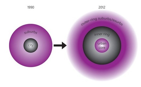
A new report tracks demographic trends across 66 U.S. metro areas. The report provides comprehensive evidence for Aaron Renn's "new donut" model of cities (pictured in above image, on the right). Renn's model proposes that city centers and outer-ring suburbs are doing well economically, but inner-ring suburbs are struggling with a new influx of poverty."
Tags: urban, economic, urban models, APHG. Via Mike Busarello's Digital Storybooks

Michael Amberg's curator insight,
May 26, 2015 11:09 PM
This shows the changes in urban geography and how the world is changing due to all the new technology available now. 
Bella Reagan's curator insight,
May 26, 2015 11:33 PM
Urban unit Summary This article goes in to depth on a newer model on cites called the donut model, as pictured similar to a donut. The donut model was created by Aaron Renn, and it shows urban development recently in cities. The center of the city is grownign economically and falling. There is an influx of people moving in , resulting in an increase of poverty too. Also more educated people are moving in like young newly educated individuals. insight The new structure of cities forming is a change from the old. With cities now developing bigger and more industrial, there are many opportunities for people for work in the center of the cit. however, many people may want the jobs but can't get them, so many of those in poverty live in the city centers in search of economic opportunities. It is also interesting to see the status of the people changing the in the city center with that also more young educated people move to city centers, most likely in search of job opportunities. This new way of urban development is modernizing the work system.
Shane C Cook's curator insight,
May 27, 2015 8:44 AM
More and more the urban stage is filling and cities are becoming once again the next big thing. After WW2 suburbs became intensively popular but now since a change in personnel views people prefer the city more.

"60 years has made a big difference in the urban form of American cities. The most rapid change occurred during the mid-century urban renewal period that cleared large tracts of urban land for new highways, parking, and public facilities or housing projects. Fine-grained networks of streets and buildings on small lots were replaced with superblocks and megastructures. While the period did make way for impressive new projects in many cities, many of the scars are still unhealed. We put together these sliders to show how cities have changed over half a century. In this post, we look at Midwestern cities such as [pictured above] Cincinnati, Ohio."

Sierra_Mcswagger's curator insight,
March 10, 2015 10:22 AM
In the above picture of Cincinnati, Ohio it is clear how much change American cities have undergone in 60 years. In the process of urban renewal these cities have been affected tremendously with the addition of new roads, businesses, and most likely the turning of land over to private developers. All previous land has been renovated and changed into the typical urbanized American city. S.S. |


