Human Interest
198.8K views | +7 today
Human Interest
Your new post is loading...
Rescooped by Skuuppilehdet from Human Geography is Everything!
Scoop.it!

Belgium and the Netherlands Swap Land, and Remain Friends

Belgium and the Netherlands Swap Land, and Remain Friends | Human Interest | Scoop.it
The discovery of a headless corpse in the Netherlands helped Belgium and its bigger Dutch neighbor resolve a property squabble that began in 1961.


In a region that has long known geopolitical and linguistic squabbles, and where Belgium has lived in the shadow of its neighbor, the land swap was anything but inevitable. In 1961, when the Meuse was reconfigured to aid navigation, it had the side effect of pushing three pieces of land onto the wrong side of the river. The uninhabited area subsequently gained a reputation for lawlessness, wild parties and prostitution.


Tags: borders, political, territoriality, Belgium, Netherlands, unit 4 political, Europe.


Via Scarpaci Human Geography
Taylor Doonan's curator insight, February 15, 2018 7:21 PM
This shows a peaceful glimpse into the future of potentially the world. When borders don't make sense a peaceful sit-down resulting in subtle changes of borders makes sense. Though this is extremely hard to attain, Belgium and the Netherlands achieved this. When a body was found and the wrong authorities were called and the correct authorities could not reasonably get to the land the deal was made creating borders between the two nations that made sense. 
Zavier Lineberger's curator insight, March 9, 2018 2:05 PM
(Europe) The Belgian-Dutch border on Meuse River was drawn to aid navigation but caused parts of each country to end up on the wrong side of the river. When a murder happened on Belgian land on the opposing river bank and required a tricky river landing, the countries realized the impracticality. Without fighting over land in other regions of the world, Belgium relinquished 35 acres and the Netherlands gave up 7 peacefully, strengthening their relations. Illogical borders like this exist throughout the world, including between Norway and Finland and the US and Canada.
brielle blais's curator insight, March 24, 2018 12:37 PM
This article shows that despite small geopolitical and linguistic squabbles, Belgium and Norway still peacefully traded land to fix unreasonable boarders. This also showcases the importance of maintaining friendly relations and practical boarders between countries. A peninsula belonging to the Netherlands was cut off by a treacherous river and Belgium, through which the Dutch needed special permission to cross over. After the peninsula became a hub for lawlessness, it was agreed by both countries that the boarder needed to be fixed. This shows that these changes can be done peacefully by countries and that geographic location is very important. 
Rescooped by Skuuppilehdet from AP HUMAN GEOGRAPHY DIGITAL STUDY: MIKE BUSARELLO
Scoop.it!

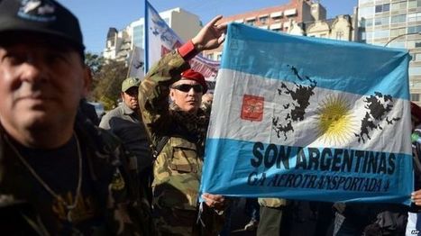
Argentina judge orders asset seizure of Falklands oil firms

Argentina judge orders asset seizure of Falklands oil firms | Human Interest | Scoop.it
A judge in Argentina orders the seizure of assets of firms drilling for oil around the Falklands, but it is unclear how it can be enforced.

Via Mike Busarello's Digital Storybooks
Matt Danielson's curator insight, September 29, 2018 5:28 PM
Ordering the Seizure of foreign oil companies on the Falkland Islands does not seem like a productive move but yet an attempt at a cry for nationalism. The Falkland Islands are  British territory which Britain was willing to go to war to keep (when they pushed out the invading Argentine forces from the Falkland Islands in the 1980's. This seizure could not even really be implemented. The foreign companies would never just hand over their assets and if The Argentinians attempt to invade the Falklands and seize them by  force they would not only have to deal with England, But also France and the USA who own some of the targeted oil firms on the Falkland Islands. The only way these firms could have any assets seized is if the people of the Falklands decide to join Argentina Which is very unlikely because the last vote was a landslide win for staying part of England's territories. 
Scooped by Skuuppilehdet
Scoop.it!

Morocco: Western Sahara Conflict Reaches British Court

Morocco: Western Sahara Conflict Reaches British Court | Human Interest | Scoop.it

The conflict over Western Sahara dates back to 1975, when, following the death of long-time ruler Francisco Franco, Spain ended its colonial rule of the territory. Spain ceded control of the territory to a joint administration by Morocco and Mauritania, but the Polisario Front - the liberation movement of the indigenous Saharawi people - refused to accept the arrangement, and launched attacks on garrisons manned by soldiers from both countries.  Morocco insists that the Western Sahara is part of its historical patrimony, and is unwilling to go beyond offering the Saharawi a limited local autonomy in what Morocco describes as the kingdom's "southern provinces."


Tags: borders, political, territoriality, Morocco.

Campbell Ingraham's curator insight, March 23, 2015 11:05 AM

This conflict represents the changes and challenges to political-territorial arrangements, because Over the course of 40 years, this territory has been greatly disputed by different states. An arrangement to have Morocco and Mauritania both control the Western Sahara only lasted 4 years, because Western Sahara valued their own sovereignty and fought back. The conflict still has not been settled, and changes could occur in the upcoming years.

Gabby cotton's curator insight, March 24, 2015 12:30 AM

Unit 5: Agriculture

The Uk is trying to label all products coming in from the Western Sahara. This is an effort to weaken Morocco's claim of the territory. The territory is highly disputed, and many products from that area say there from Morocco and not Western Sahara.


This relates to unit 5 because not only is it talking about growing and farming, but it is also talking about the area in which the crops come from. It also relates to unit 4 as the territory is highly disputed and the UK refuses to  label the crops as 'Moroccan'

Rescooped by Skuuppilehdet from Haak's APHG
Scoop.it!

Who Owns The North Pole?

"Though uninhabited and full of melting ice caps, the Arctic is surprisingly an appealing piece of real estate. Many countries have already claimed parts of the region. So who technically owns the North Pole? And why do these nations want it so bad?"


Via Dean Haakenson
Rich Schultz's curator insight, January 2, 2015 5:52 PM

Great question!  I think we all know the answer...Santa Claus!! ;)

Sammy Shershevsky's curator insight, January 17, 2015 4:57 PM

The video discusses a big topic in discussion today - Who really owns the North Pole? Although the North Pole is uninhabited, many countries have claimed to take ownership of the vast majority of land (or, ice). Canada has already claimed that the North Pole is part of its nation. Russia has put up Russian flags on the North Pole (such as underwater) but does that really make North Pole a Russian territory? The media plays a role in this by offering different opinions on who should and who deserves the right to own the North Pole. You might read a Canadian article that lists all the outright reasons why the North Pole is or deserves to be a Canadian territory. 

Felix Ramos Jr.'s curator insight, March 6, 2015 7:26 PM

In my opinion, I don't understand how the United nations can be seen as an entity that, essentially, controls who would have rights to a place like the North Pole(technically, not owned by anyone).  I, naively, understand the basics of the U.N.  In short, it is an organization that was formed, post-WW I or II, as a governing board for world-issues.


 With that being said, how can they believe that their "law" is the all-powerful one?  If I'm a leader of a country who is not a member of the U.N., do I really care what they say?   I just find it odd that this narrator speaks about the issue while holding the U.N. as a supreme authority.  I know that this video is just a quick fun type of video but it leaves me with wanting to hear the perspective of a non-U.N. member.  But a very interesting topic, none the less.


Scooped by Skuuppilehdet
Scoop.it!

Canada on mission to map Arctic, lay claim to broader boundaries

Canada on mission to map Arctic, lay claim to broader boundaries | Human Interest | Scoop.it
Canada has dispatched two icebreakers to map the Arctic seabed beneath the North Pole to support a bid to extend the country's maritime territory deeper into the waterways at the top of the world.
GTANSW & ACT's curator insight, August 18, 2014 7:19 PM

Option - marine environments and management

MsPerry's curator insight, August 25, 2014 3:30 PM

APHG-Unit 4

Rescooped by Skuuppilehdet from Geography & Current Events
Scoop.it!

Challenges in Defining an Israeli-Palestinian Border

Challenges in Defining an Israeli-Palestinian Border | Human Interest | Scoop.it
There are major hurdles in drawing borders between Israel and a future Palestine.

Israeli and Palestinian negotiators resumed peace talks in Washington in July for the first time in three years. While the talks are initially expected to focus on procedural issues, they are already beginning to take on a last-ditch quality. Explore some of the contentious issues that negotiators have faced in drawing borders between Israel and a future Palestinian state.


Via Mr. David Burton
Mr. David Burton's curator insight, July 17, 2014 10:49 PM

Thoughts from my friend Seth...


Seth Dixon's insight:

This five-part video report from the New York Times is from 2011, but still has some pertinent information, even if the situation has changed in some of the particulars.  These videos brings important voices from a variety of perspectives on the Israeli-Palestinian conflict; together they all  show how a complex cultural and political geography leads to many of the difficulties in creating a long-lasting peace.  The discipline of geography doesn't simple study the peace process--it is a part of it.  The creation of borders and the cartographic process play a critical role in solving territorial issues.  Geography can be both the problem and the solution.

MsPerry's curator insight, August 12, 2014 7:00 PM

APHG-U4

Alec Castagno's curator insight, December 17, 2014 1:37 PM

This video explains why defined borders are an important part of any potential solution for the conflict, and why it is such a complex issue. While agreeing on a border that benefits both seems like it should be an easy task, the realities on the ground and actions from both sides make it anything but easy. 

Scooped by Skuuppilehdet
Scoop.it!

Crimea, Nagorno-Karabakh and the Gordian Knot

Crimea, Nagorno-Karabakh and the Gordian Knot | Human Interest | Scoop.it
Is this an opportune moment for Eurasian powers to tackle the festering Nagorno-Karabakh conflict?
Stephen Zimmett's curator insight, May 19, 2014 12:26 PM

You can find this on https://en.wikipedia.org/wiki/Nagorno-Karabakh

Jason Wilhelm's curator insight, May 27, 2014 12:44 PM

The Crimea region has been hotly debated and fought over for quite a while now. The collapse of the USSR created a power vacuum in Eastern Europe which led to the contest for power in many of the former Soviet Satellite countries, including Ukraine. The Crimean peninsula, while mostly occupied by Russians, is legally a part of Ukraine, but maybe not for long. The Russian government is seemingly working to annex the peninsula while the Ukrainian government is working to keep it. The region will continue to be under lots of tugging and pulling for a while until a single government wins in to their nation. 

Benjamin Jackson's curator insight, December 14, 2015 11:36 AM

this is a perfect example of some of the conflicts which have resulted because of the failure of the soviet state. with many of these states trying to gain land that the view as theirs, these wars can only really end in bloodshed or massive investments in peace.

Rescooped by Skuuppilehdet from AP HUMAN GEOGRAPHY DIGITAL STUDY: MIKE BUSARELLO
Scoop.it!

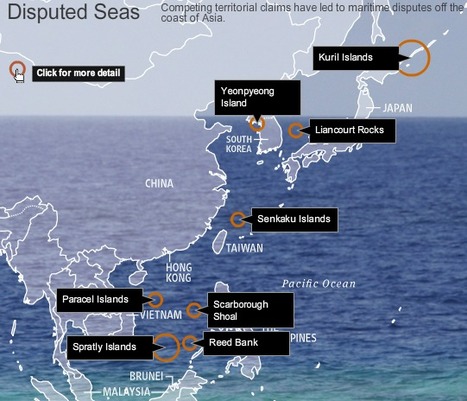
Disputed Isles

Disputed Isles | Human Interest | Scoop.it

Competing territorial claims have led to maritime disputes off the coast of Asia. See a map of the islands at issue.


This is an nice interactive map that allows the reader to explore current geopolitical conflicts that are about controlling islands.  This is an good source to use when introducing Exclusive Economic Zones, which is often the key strategic importance of small, lightly populated islands.   


Tags: EastAsia, SouthEastAsia, political, unit 4 political, territoriality, autonomy, conflict, economic. 


Via English Gallery, Mike Busarello's Digital Storybooks
Elizabeth Bitgood's curator insight, April 24, 2014 2:40 PM

This interactive page gives relevant information about islands that are disputed over in southeast Asia.  I liked it because you could see the information in context with the map.

Jess Deady's curator insight, May 4, 2014 9:47 PM

This is like a game of Monopoly when people try and get all the houses or businesses. Except this is real life and real isles. Whose is whose? How does Asia decide where and how the EEZ's should be divided.

Benjamin Jackson's curator insight, December 14, 2015 12:05 PM

considering that half of the nations involved are island nations, this is hardly surprising. every nation has issues with their neighbors. even the us and Canada dispute some territory. but these disputes can hardly end as well, when half of these nations have fought wars with each other for most of their histories.

Scooped by Skuuppilehdet
Scoop.it!

22+ International Borders Around The World

22+ International Borders Around The World | Human Interest | Scoop.it
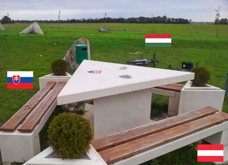
History (and sometimes, unfortunately, current events) shows us just how easily national borders can change, but we still like to think that they are permanent fixtures. These photos of different national borders around the world show you how both friendly and hostile nations like to fence off their turf.
Courtney Barrowman's curator insight, June 1, 2015 9:38 AM

Unit 4

Dwane Burke's curator insight, June 3, 2015 6:16 PM

What do these say about the world?

Rescooped by Skuuppilehdet from AP HUMAN GEOGRAPHY DIGITAL STUDY: MIKE BUSARELLO
Scoop.it!

Complex International Borders

More complex international borders in this follow up to part 1. 
In this video I look at even more enclaves and exclaves."


Via Mike Busarello's Digital Storybooks
Danielle Lip's curator insight, April 7, 2015 9:13 PM

Borders seem to be a problem whether you live in one continent or another, everyone wants power and control but not everyone can gain it. This video focuses and goes into depth about enclave and exclave borders, showing the irregularity of the borders in different areas that causes conflicts and problems. An example of a problem that the citizens have to deal with is that some villages can not leave due to the road blocks due to the borders. I can not imagine not being able to leave a certain area for all that time, I would go insane and I imagine those people are as well. International borders power has to be split somehow and not everyone can always come to an easy decision because parts of the land are claimed but the people do not have any control of it. Irregular borders cause more trouble than they are worth in my opinion. The final interesting fact about this video was that you learn that Tajikistan and Kyrgyzstan are the two locations that have the most irregular border, these places must have the most conflict and problems. These borders are in places such as Germany, South Asia, China, Belgian, Sweden and Central Asia.

Nicholas A. Whitmore's curator insight, December 17, 2015 5:17 PM

A fascinating look into the complexity of borders. It is always important to keep in mind when looking at maps that the borders are neither permanent or defined as it exists in reality. Borders on world maps are rough estimations of what the borders actually are for they can't depict precise details on such a large scale. Furthermore regional/local maps sometimes do not whether as to conform to the border misconception unfortunately. In Central Asia as defined int he video the border were primarily a result of the Soviet Unions attempts to divided ethnic minorities reducing their power (primarily Stalin). As a result the countries after the collapse proceeded to claim the ethnic groups which created enclaves within each-other. As long as these groups are on peaceful terms this kind of thing isn't an issue. Unfortunately it does make the peoples lives in the enclaves slightly more difficult due to having to cross the border twice to see the rest of your country. This kind of thing was even done to the Jews in the first century AD who like the Russians wanted to eliminate or at least reduce attempts at revolution by the local populace. Hopefully Central Asia has or will make the lives of these enclaves easier.

David Stiger's curator insight, October 28, 2018 8:56 PM
I think it's fair to say that people in general take maps for granted. The devotion and reverence for the written word - specifically the published written word - prevents people from realizing that much of the world is a social construct. Geographically, borders are social constructs - sometimes loose agreements between different groups of people to establish territorial boundaries in order to claim resources. This video, which speaks to the complicated reality of territorial enclaves and 'exclaves,' illustrates how borders are social constructs. They can often be illogical, awkward, and highly disputable. Examining the several exclaves and enclaves shared between Armenia and Azerbaijan is evidence of the geopolitical mess that disputed borders create.  What is most fascinating about this case is the assessment of how Joseph Stalin tampered with international borders as a geopolitical strategy in order to sow instability and weakness. This strategy allowed the the Soviets to more easily conquer and subjugate foreign peoples - all in the name of proletariat revolution. 
Rescooped by Skuuppilehdet from AP HUMAN GEOGRAPHY DIGITAL STUDY: MIKE BUSARELLO
Scoop.it!

Fragile States Index

Fragile States Index | Human Interest | Scoop.it

"Weak and failing states pose a challenge to the international community. In today’s world, with its highly globalized economy, information systems and interlaced security, pressures on one fragile state can have serious repercussions not only for that state and its people, but also for its neighbors and other states halfway across the globe.  The Fragile States Index (FSI), produced by The Fund for Peace, is a critical tool in highlighting not only the normal pressures that all states experience, but also in identifying when those pressures are pushing a state towards the brink of failure."


Via malbert, Mike Busarello's Digital Storybooks
Melissa Marshall's curator insight, August 28, 2014 12:57 AM

How can political stability and security be measured? The Fragile States Index is a statistical ranking designed to measure the effective political institutions across the globe.

MsPerry's curator insight, September 1, 2014 9:49 AM

APHG-Unit 4

Scooped by Skuuppilehdet
Scoop.it!

What is a part of the United States?

MsPerry's curator insight, August 12, 2014 6:54 PM

APHG-U4

CHS AP Human Geography / Beth Gehle & Amy Rossello's curator insight, August 17, 2014 5:28 PM

Use in Political Geo unit, or for Canada and US region

Tanya Townsend's curator insight, October 12, 2015 11:09 PM

I honestly feel like we are never taught about these areas ever in US schools. We are always drilled about the 50 states and that's it. I would be interested in learning the history behind why this is still the case and what is keeping our government from considering them part of the states. The fact that they wont even consider American Samoa's citizens is a disgrace.

Scooped by Skuuppilehdet
Scoop.it!

Lies Your World Map Told You: 5 Ways You're Being Misled

Lies Your World Map Told You: 5 Ways You're Being Misled | Human Interest | Scoop.it

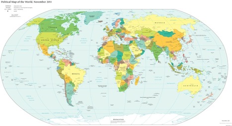
"Unfortunately, most world political maps aren't telling you the whole story. The idea that the earth's land is cleanly divvied up into nation-states - one country for each of the world's peoples - is more an imaginative ideal than a reality. Read on to learn about five ways your map is lying to you about borders, territories, and even the roster of the world's countries."

Sally Egan's curator insight, June 23, 2014 6:32 PM

Amazing stories on the World's changing Geopolitical status. Current stories about disputed borders, unrecognised territories and  newly declared nations.

Adilson Camacho's curator insight, June 29, 2014 9:41 PM

Nunca é "Toda a Verdade" ... 

MsPerry's curator insight, August 12, 2014 7:49 PM

APHG-U1

Scooped by Skuuppilehdet
Scoop.it!

Trans-Dniester pleads to join Russia

Trans-Dniester pleads to join Russia | Human Interest | Scoop.it

Pro-Russian politicians and activists in Moldova's breakaway Trans-Dniester region have asked the Russian parliament to draft a law that would allow their territory to join Russia.

Coach Frye's curator insight, March 20, 2014 10:46 AM

The Trans-Dniester region functions as a working state, but is not internationally recognized as such.  Members of this region are hoping Russia will annex them for political and economic stability.

Jacob Crowell's curator insight, October 15, 2014 1:08 PM

A nation that is not internationally recognized, Trans-Dniester reflect how borders are subject to changed based on cultural differences. The region identifies with Russia more than it does with Moldova. After the USSR broke up, the borders were created without considering demographic and cultural makeup of each region of the new states. With the Ukraine and with Trans-Dniester we see how many eastern European regions still identify with Russia. As Russia seems more willing to expand, many borders are likely to change in the area.

Felix Ramos Jr.'s curator insight, April 1, 2015 8:10 PM

This situation only further complicates Eastern European dynamics.  One thing that stood out to me after reading this aritcle is the reality that anti-Russian Ukraine is sandwiched between pro-Russian eastern Ukraine and pro-Russian eastern Moldova.  This situation can only get uglier.