Human Interest
198.8K views | +4 today
Follow
Human Interest
Your new post is loading...
Scooped by Skuuppilehdet
Scoop.it!

China is trying to turn itself into a country of 19 super-regions

China is trying to turn itself into a country of 19 super-regions | Human Interest | Scoop.it

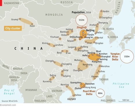
"China's urbanization is a marvel. The population of its cities has quintupled over the past 40 years, reaching 813m. By 2030 roughly one in five of the world’s city-dwellers will be Chinese. But this mushrooming is not without its flaws. Restraining pell-mell urbanization may sound like a good thing, but it worries the government’s economists, since bigger cities are associated with higher productivity and faster economic growth. Hence a new plan to remake the country’s map.


No comment yet.
Scooped by Skuuppilehdet
Scoop.it!

Amazon Is Building a Colossal Warehouse Where America's Biggest Mall Once Stood

Amazon Is Building a Colossal Warehouse Where America's Biggest Mall Once Stood | Human Interest | Scoop.it

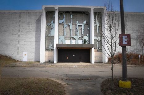
"The Seattle-based internet book seller Amazon just announced plans to open an enormous fulfillment center in the North Randall, Ohio. This is a big deal for the small community which has suffered greatly since the Randall Park Mall, once the largest in America, shut down due to retail sales moving online. Amazon is actually building its new warehouse on the same land where the mall once stood. The irony of this is lost on no one."

Matt Manish's curator insight, January 18, 2018 7:48 PM
North Randall, Ohio was once home of the largest mall in America until it lost all of it's business to online shopping. Ironically, Amazon the online shopping website is looking to build a new warehouse in the old mall building that is now vacant. This would have a huge positive impact on the town's economy. The majority of citizens in North Randall are excited for Amazon's plans with this warehouse as it will create 2,000 jobs in the community. This is a big deal for North Randall since many of it's citizens lost their jobs at the previous mall. Overall, this is going to have a great impact on the North Randall community in a positive way and is a good example of economic geography.
tyrone perry's curator insight, February 12, 2018 3:57 PM
When any business closes its bad for the company but worse for the employees.  It leaves multiple people unemployed.  But when a mall closes it is detrimental for the whole town/city and even at times the state.  So when amazon says it is building a new warehouse that is going to be just as big the mall was where it once stood that is going to boost the surrounding economies and create much needed jobs.  Amazon will big in revenue, jobs will create money and money will lead to spending which will also bing upgrades to the surrounding geographical areas!

Rescooped by Skuuppilehdet from HOMEHISTORY
Scoop.it!

"The Last of the Free Seas"

"The Last of the Free Seas" | Human Interest | Scoop.it

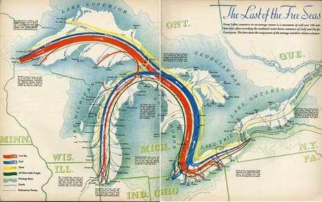
"The Last of the Free Seas is the title of this fantastic map of the Great Lakes made by Boris Artzbasheff.  It was published in Fortune Magazine in July 1940."


Via Ben Salve
PIRatE Lab's curator insight, August 8, 2017 9:08 PM
Share your insight
Rescooped by Skuuppilehdet from Geography
Scoop.it!

4 ways to make a city more walkable

4 ways to make a city more walkable | Human Interest | Scoop.it
Freedom from cars, freedom from sprawl, freedom to walk your city! City planner Jeff Speck shares his "general theory of walkability" -- four planning principles to transform sprawling cities of six-lane highways and 600-foot blocks into safe, walkable oases full of bike lanes and tree-lined streets.

Via CT Blake
Mr Mac's curator insight, June 13, 2017 10:09 AM
Unit 7 - New Urbanism
GTANSW & ACT's curator insight, August 31, 2017 8:01 PM
Enhancing urban liveability - creating better cities for the future
GTANSW & ACT's curator insight, August 31, 2017 8:01 PM
Enhancing liveability
Rescooped by Skuuppilehdet from HMHS History
Scoop.it!

Enabling Globalization: The Container

Enabling Globalization: The Container | Human Interest | Scoop.it

"The ships, railroads, and trucks that transport containers worldwide form the backbone of the global economy. The pace of globalization over the last sixty years has accelerated due to containers; just like canals and railroads defined earlier phases in the development of a global economy. While distance used to be the largest obstacle to regional integration, these successive waves of transportation improvements have functionally made the world a smaller place. Geographers refer to this as the Space-Time Convergence."


Via Michael Miller
Norka McAlister's curator insight, February 2, 2015 5:19 PM

Containers are part of globalization. It saves time and allows for extra space to store more products. Also, it is easier to handle using ships, railroad, and trucks while also facilitating more quality in terms of safety. However, on the other hand, with the creation of these containers employ mainly the use of technology which, unfortunately, downsizes the workforce. This, as a result, increases the unemployment rate for citizens. Although, when it comes to recycling, the idea of making houses with these containers helps families in diverse ways such as decreased costs, energy efficiency, and very short construction time. Containers have shaped the concept of shipping and living for many years, impacting regions with more business and expansion trades around the world.

Cody Price's curator insight, May 26, 2015 10:57 PM

This article describes the basics of globalization and what technology really allowed globalization to spread, the shipping the container. It allowed thing to be shipped organized and more efficiently. These containers fit together perfectly. It helps ideas and products transport all over the world and spread pop culture. 


This relates to the idea in unit 3 of globalization. These shipping container allow ideas and products to be shipped all over the world. The shipping container was the key to better connecting the world. 

BrianCaldwell7's curator insight, April 5, 2016 8:14 AM

I've posted here several resources about the global economy and the crucial role that containers play in enabling globalization.  In this article for National Geographic Education, I draw on many of these to to put it all in one nice container.  


Tags: transportation, globalization, diffusion, industry, economic.

Scooped by Skuuppilehdet
Scoop.it!

America's 'Megaregions' using Commuter Data

America's 'Megaregions' using Commuter Data | Human Interest | Scoop.it
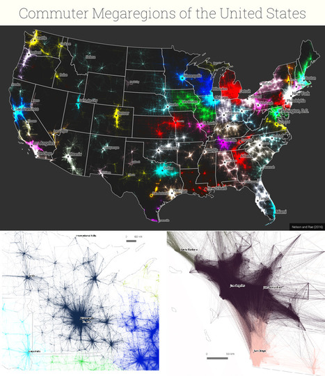
New maps use math to define the amorphous term.
PIRatE Lab's curator insight, December 10, 2016 10:30 AM
Another example is the long line of defining the new geography.
Boris Limpopo's curator insight, December 11, 2016 1:43 AM
Le macroregioni americane con i dati del pendolarismo
Tom Cockburn's curator insight, December 13, 2016 3:53 AM
Plenty of space in the middle it seems
Scooped by Skuuppilehdet
Scoop.it!

The 20 Most Bike-Friendly Cities on the Planet

The 20 Most Bike-Friendly Cities on the Planet | Human Interest | Scoop.it
Investment in bicycle infrastructure is a modern and intelligent move. Many cities get this. Many don't.


Tags: urban, place, transportation, planning, urbanism, architecture.

joellemillery's curator insight, August 28, 2016 5:28 AM
In Munich, bike paths feel overcrowded, for example, there is a need for a new #urbanism #transportation # plan ;-)
malek's comment, September 6, 2016 10:09 AM
@pdeppisch Montreal made it 20 !!
Rescooped by Skuuppilehdet from HOMEHISTORY
Scoop.it!

Bad drivers are a good indicator of a corrupt government

Bad drivers are a good indicator of a corrupt government | Human Interest | Scoop.it

"Traffic accidents kill 1.25 million people per year, and it’s well-known that those deaths are disproportionately in low- and middle-income countries. Over at CityMetric, writer James O’Malley has added an interesting wrinkle, by showing a correlation between the number of traffic fatalities in a country and the corruptness of its government."


Via Ben Salve
Adilson Camacho's curator insight, June 10, 2016 2:12 PM
Será?
Caitlyn Scott's curator insight, June 14, 2016 1:05 AM
This article shows a scarily real insight into the effects of corruption on certain countries. Would be useful for situations where looking at the broad range of effects of corruption but also has some interesting statistics regarding earnings and road fatalities.
Scooped by Skuuppilehdet
Scoop.it!

This is an incredible visualization of the world's shipping routes

This is an incredible visualization of the world's shipping routes | Human Interest | Scoop.it

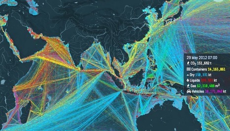
"Ships carry 11 billion tons of goods each year. This interactive map shows where they all go.  About 11 billion tons of stuff gets carried around the world every year by large ships. Clothes, flat-screen TVs, grain, cars, oil — transporting these goods from port to port is what makes the global economy go 'round.  And now there's a great way to visualize this entire process, through this stunning interactive map from the UCL Energy Institute."

Caitlyn Scott's curator insight, June 14, 2016 10:25 PM
This resource shows great detail into where are products travel when they are imported but also shows us what and where Australian products are going. Good source in regards to showing how large Australia's export market is. Article contains a good amount of information as to why the routes shown on the map are taken as well as having in-depth data showing the different cargo on board ships. This data helps high light what different countries are renowned for in their exports as well as giving so information into why some countries are poorer than others when analysing their exports. Planned use within unit regarding the cost of Australian exports and its sustainability for the future.      
Alex Smiga's curator insight, September 1, 2016 7:24 PM
A rainbow of shipping routes and info
James Piccolino's curator insight, January 18, 2018 7:35 PM
This is incredibly interesting. I am a History guy, I love the subject and I love finding things I did not know about it. This fun interactive map did not so much contribute to direct knowledge of shipping/trade history as much as it has sparked my interest in it. There are old trade routes, who traveled down them and with what, and the ways those trade routes changed civilization and even sometimes started new ones. I never expected to say the words "Wow trade routes are fun!" but here I am. By the way, if you turn on absolutely everything at once, it creates this beautiful image. It is almost oddly relaxing. Sort of in the way some paintings can be.
Scooped by Skuuppilehdet
Scoop.it!

Cincinnati Built a Subway System 100 Years Ago–But Never Used It

Cincinnati Built a Subway System 100 Years Ago–But Never Used It | Human Interest | Scoop.it

Interstate 75 slices the city of Cincinnati in half like an orange. On one side is the city’s Catholic working class west, while the east side is favored by...

No comment yet.
Scooped by Skuuppilehdet
Scoop.it!

How To Travel While Black During Jim Crow

How To Travel While Black During Jim Crow | Human Interest | Scoop.it

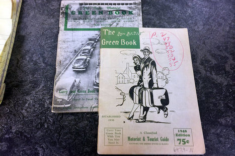
"A postal worker created a guide for black travelers that was published almost every year from 1936 to 1966."

No comment yet.
Scooped by Skuuppilehdet
Scoop.it!

Most Cyclists Are Working-Class Immigrants, Not Hipsters

Most Cyclists Are Working-Class Immigrants, Not Hipsters | Human Interest | Scoop.it

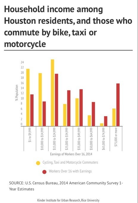
"Urban planners are noticing a cultural gap between bike advocates and others who bike. Planners see a particular type of cyclist: a working-class person – usually a minority and often a recent immigrant – riding to work on whatever type of bike he can get his hands on. Those cyclists are men and women for whom biking isn’t an environmental cause or a response to an urban trend but a means of transportation that’s cheaper than a car and faster than walking."

No comment yet.
Rescooped by Skuuppilehdet from AP HUMAN GEOGRAPHY DIGITAL STUDY: MIKE BUSARELLO
Scoop.it!

Jim Crow-Era Travel Guides

Jim Crow-Era Travel Guides | Human Interest | Scoop.it

"From 1936 to 1966, the 'Green Book' was a travel guide that provided black motorists with peace of mind while they drove through a country where racial segregation was the norm and sundown towns — where African-Americans had to leave after dark — were not uncommon."


Via Mike Busarello's Digital Storybooks
John Puchein's curator insight, November 12, 2015 8:08 AM

All I have to say is....wow. 

Scooped by Skuuppilehdet
Scoop.it!

Peru gives landlocked Bolivia a piece of Pacific coast to call its own

Peru gives landlocked Bolivia a piece of Pacific coast to call its own | Human Interest | Scoop.it

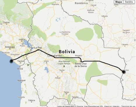
"It might be a strip of sand without even a jetty but a small stretch of the Pacific coast now harbors Bolivia's dream of regaining a coast and becoming a maritime nation. The landlocked Andean country has won access to a desolate patch of Peru's shoreline, fueling hopes that Bolivia will once again have a sea to call its own. President Evo Morales signed a deal yesterday with his Peruvian counterpart, Alan García, allowing Bolivia to build and operate a small port about 10 miles from Peru's southern port of Ilo. The accord, sealed with declarations of South American brotherhood, was a diplomatic poke at Chile, the neighbor that seized Bolivia's coast and a swath of Peruvian territory in the 1879-84 war of the Pacific."

Albahae Geography's curator insight, July 22, 2018 10:48 AM
Unit 4
dustin colprit's curator insight, September 29, 2018 10:24 PM
Having access to a coast provides many benefits to a country. If Peru follows through and allows Bolivia use of the coast, both countries may profit from the deal. If Bolivia is unable to gain access to the coast it will continue to be dependent on neighboring countries.   
Kelvis Hernandez's curator insight, September 29, 2018 10:40 PM
A deal between the two countries of Peru and Bolivia giving the latter a small stretch of land to call their own. This is a win for Bolivia who had been left without a coastal shore since Chile took their land in the late 19th century during the War of the Pacific. As both a sign of friendship and a dig on Chile, Peru leased out a "1.4 square mile patch of sand" to Bolivia for 99 years. Morales, the leader of Bolivia, knows how much a port would do for the country being able to export more goods, dock naval vessels and bring more trade and investment into the country. 
 
Scooped by Skuuppilehdet
Scoop.it!

When Climate Change Meets Sprawl: Why Houston's ‘Once-In-A-Lifetime' Floods Keep Happening

When Climate Change Meets Sprawl: Why Houston's ‘Once-In-A-Lifetime' Floods Keep Happening | Human Interest | Scoop.it

"Unchecked development remains a priority in the famously un-zoned city, creating short-term economic gains for some, but long term flood risk for everyone."

Deanna Wiist's curator insight, September 12, 2017 8:56 PM

Houston's development boom and reduction of wetlands leave region prone to more severe flooding.  Here is a great map of the change in impervious surfaces in the region from 1940 to 2017--when you combine that with record-breaking rainfall the results are catastrophic.  But a local understanding of place is critical and this viral post--Things non-Houstonians Need to Understand--is pretty good.     


Tagsphysical, fluvialwatercoastal, urban, planningtransportation, architecture.

Tiffany Cooper's curator insight, September 26, 2017 11:11 AM
#geo130
Vincent Lahondère's curator insight, October 31, 2017 1:27 PM

Un dossier sur les inondations à Houston (en anglais). La présentation est très originale.

Rescooped by Skuuppilehdet from U.S HISTORY SHACK : MIKE BUSARELLO
Scoop.it!

America's Best Long Trails

America's Best Long Trails | Human Interest | Scoop.it
Plan your next big hike with this map of America's most-loved long trails.

Via Mike Busarello's Digital Storybooks
No comment yet.
Rescooped by Skuuppilehdet from HMHS History
Scoop.it!

Reefer Madness

Reefer Madness | Human Interest | Scoop.it

"There are around 6,000 cargo vessels out on the ocean right now, carrying 20,000,000 shipping containers, which are delivering most of the products you see around you. And among all the containers are a special subset of temperature-controlled units known in the global cargo industry, in all seriousness, as reefers.

70% of what we eat passes through the global cold chain, a series of artificially-cooled spaces, which is where the reefer comes into play."


Via Michael Miller
GTANSW & ACT's curator insight, October 10, 2015 6:19 PM

An interesting addition to any study of global trade connections 

BrianCaldwell7's curator insight, April 5, 2016 8:06 AM

I have written in the past about how containerization has remade the world we live in, but not much about the role of the refrigerated container (reefer).  So many economic geographies and agricultural geographies in the our consumer-based society hinge of this technological innovation.  This is yet another podcast from 99 Percent Invisible that is rich in geographic content.  


Tags: transportation, food distribution, technology, globalization, diffusion, industry, economic, podcast.

Scooped by Skuuppilehdet
Scoop.it!

Ship to shore: tracking the maritime motorways

Ship to shore: tracking the maritime motorways | Human Interest | Scoop.it

"It is estimated that 97 per cent of all trade – the things we buy in shops – will have been transported in containers by ships at sea. The container vessel, stacked high with uniformly-sized metal boxes, has become a symbol of our globalized world. This is a world of imports and exports, a world where moving things across huge distances keeps the price of daily commodities low as items are manufactured in one place, then packaged in another, before arriving on the shores where they will eventually be sold. In recent geographical literature, attention has turned to the world at sea – a space traditionally overlooked. Geography means ‘Earth-writing’ and geographers have taken the origins of the term very seriously. They have written primarily about the Earth: the ground, the soil, the land. The sea is something ‘out there’ – seemingly disconnected from our everyday lives. However, an appreciation of the world as made from flows and connections has enabled geography to recognize that the sea is essential to our landed life." http://wp.me/p2Ij6x-5DS


Tags: transportation, globalization, diffusion, industry, economic.

Ivan Ius's curator insight, February 19, 2017 3:38 PM
Geographic Concepts: Patterns and Trends, Geographic Perspective, Interrelationships
Scooped by Skuuppilehdet
Scoop.it!

India watches anxiously as Chinese influence grows

India watches anxiously as Chinese influence grows | Human Interest | Scoop.it
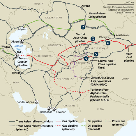
A $46bn economic corridor through disputed territories in Kashmir is causing most concern
brielle blais's curator insight, April 1, 2018 2:41 PM
Adding infrastructure to improve trade with other countries is a strong step taken by China. This new silk road showcases how important trade is to geopolitics. Other countries are watching as this unfolds, learning and wondering what will come of it, as China continues to make economic power moves for not only it's own country but the global economy as well. 
Rescooped by Skuuppilehdet from Human Geography is Everything!
Scoop.it!

Superblocks to the rescue: Barcelona’s plan to give streets back to residents

Superblocks to the rescue: Barcelona’s plan to give streets back to residents | Human Interest | Scoop.it

"The Catalan capital’s radical new strategy will restrict traffic to a number of big roads, drastically reducing pollution and turning secondary streets into ‘citizen spaces’ for culture, leisure and the community.  Black routes allow public transport and cars at 50km/h, while green routes only allow private vehicles at 10km/h to prioritize pedestrians and cycling."


Tags: Catalonia, Spain, mobility, transportation, place, neighborhood, urban, planning, urbanism.


Via Scarpaci Human Geography
Scooped by Skuuppilehdet
Scoop.it!

Bad drivers are a good indicator of a corrupt government

Bad drivers are a good indicator of a corrupt government | Human Interest | Scoop.it

"Traffic accidents kill 1.25 million people per year, and it’s well-known that those deaths are disproportionately in low- and middle-income countries. Over at CityMetric, writer James O’Malley has added an interesting wrinkle, by showing a correlation between the number of traffic fatalities in a country and the corruptness of its government."

Adilson Camacho's curator insight, June 10, 2016 2:12 PM
Será?
Caitlyn Scott's curator insight, June 14, 2016 1:05 AM
This article shows a scarily real insight into the effects of corruption on certain countries. Would be useful for situations where looking at the broad range of effects of corruption but also has some interesting statistics regarding earnings and road fatalities.
Rescooped by Skuuppilehdet from AP HUMAN GEOGRAPHY DIGITAL STUDY: MIKE BUSARELLO
Scoop.it!

The Pan American Highway: The Longest Road In The World

The Pan American Highway: The Longest Road In The World | Human Interest | Scoop.it
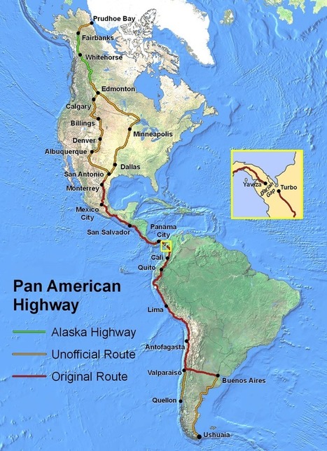
At its fullest extent the Pan-American Highway is a network of roads stretching from Prudhoe Bay, Alaska, to Ushuaia, Argentina, a distance of around 30,000 kilometres (19,000 miles).

Via malbert, Mike Busarello's Digital Storybooks
James Piccolino's curator insight, February 8, 2018 6:57 AM
Wow,yet another feature in our country that I never knew about, I'm finding the increasing amount of things I never even heard of right in our own backyard troubling (although if it lies on the education system or just my own flat out ignorance I have not decided yet). It is interesting that so many people turn to these things as challenges to beat and overcome where most would most likely view it as just another long road for transportation.
tyrone perry's curator insight, March 22, 2018 1:21 PM
 I couldn’t imagine the sites that you would see traveling the road between two different continents in over 14 countries.  30,000 miles, official  and unofficial road with a stretch of road that is uninhabited and another stretch that has no real roads.   I for one would love the beautiful sites that you would see but I would hate the actual traveling, driving  that many miles would drive me crazy.  one thing that I wonder is if you would actually be able to do it without any problems within each country.  The article also does not say How people made it across the Darian gap.  The top of one continent to the bottom of another is just amazing.
Kelvis Hernandez's curator insight, September 29, 2018 9:00 PM
This sounds like it would be the best idea for a road trip. The question is whether you are making the trip because you can say you did or to see as much as possible. I prefer the latter so given the number of breaks needed in between to be able to get up, stretch, and see some interesting sites on the road, I would need to take a lot of time off, but it would definitely be worth it. All the different cultures and people you would meet as you pass over the border of fourteen different countries. Goes to show that we are more connected than we believe, literally. 
 
Rescooped by Skuuppilehdet from AP HUMAN GEOGRAPHY DIGITAL STUDY: MIKE BUSARELLO
Scoop.it!

All the roads that lead to Rome

All the roads that lead to Rome | Human Interest | Scoop.it

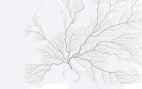
"As the saying goes, 'All roads lead to Rome.' Folks at the moovel lab were curious about how true this statement is, so they tested it out. They laid a grid on top of Europe, and then algorithmically found a route from each cell in the grid to Rome, resulting in about half a million routes total. Yep, there seems to be a way from Rome from every point."


Tags: fluvial, mobility, transportation, mapping.


Via Mike Busarello's Digital Storybooks
Gilbert C FAURE's comment, January 24, 2016 11:09 AM
a new geography of europe! fascinating for politicians
Gilbert C FAURE's curator insight, January 24, 2016 11:10 AM

une nouvelle géographie de l'Europe! pour les politiques!!

Leonardo Wild's curator insight, January 24, 2016 1:00 PM

But many roads didn't leave Rome ... a small detail that has been lost to history.

Scooped by Skuuppilehdet
Scoop.it!

My Car Pays Cheaper Rent Than Me

My Car Pays Cheaper Rent Than Me | Human Interest | Scoop.it

"In our dense cities where land is valuable and housing is expensive, why do our cars pay cheaper rent than people?"

No comment yet.
Scooped by Skuuppilehdet
Scoop.it!

The 5, the 101, the 405: Why Southern Californians Love Saying 'the' Before Freeway Numbers

The 5, the 101, the 405: Why Southern Californians Love Saying 'the' Before Freeway Numbers | Human Interest | Scoop.it

"How did Southern Californians come to treat their highway route numbers as if they were proper names?"

No comment yet.