

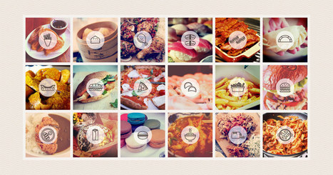

Explore the popularity of some of the world’s favourite foods on Instagram. Discover Instagram’s capital of curry, which cities are big on burgers, and where pulled pork is most prolific.
Via Michael Miller
Get Started for FREE
Sign up with Facebook Sign up with X
I don't have a Facebook or a X account


 Your new post is loading...
 Your new post is loading...
Your new post is loading...
Explore the popularity of some of the world’s favourite foods on Instagram. Discover Instagram’s capital of curry, which cities are big on burgers, and where pulled pork is most prolific. Via Michael Miller 
No comment yet.
Sign up to comment
Tips from a geographer who's seen it all.
Tags: mapping, cartography, 201, perspective, map. Via CT Blake

Angus Henderson's curator insight,
July 2, 2015 2:04 AM
A mapping 'take-down' of great detail, with lots of of interesting linked examples
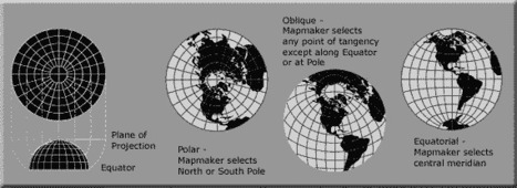
A map projection is used to portray all or part of the round Earth on a flat surface. This cannot be done without some distortion. Every projection has its own set of advantages and disadvantages. There is no "best" projection. The mapmaker must select the one best suited to the needs, reducing distortion of the most important features. Mapmakers and mathematicians have devised almost limitless ways to project the image of the globe onto paper. Scientists at the U. S. Geological Survey have designed projections for their specific needs—such as the Space Oblique Mercator, which allows mapping from satellites with little or no distortion. This document gives the key properties, characteristics, and preferred uses of many historically important projections and of those frequently used by mapmakers today.

Carlee Allen's curator insight,
March 26, 2015 6:58 PM
This article explains and talks about 18 specific map projections. It gives a lot of detail about all of them, and describes the disadvantages and uses for all of them.
I thought that this was interesting because I learned more about map projections, and actually how people use them. 
Leah Hood's curator insight,
August 22, 2017 5:02 PM
This article chronicles 18 map projections, how they are mathematically rendered with their own unique set of advantages and disadvantages. Questions to Ponder: Why do map projections matter? Is one global map projection inherently better than the rest? What is your favorite? Tags: Mapping, visualization, map projections, cartography, perspective.
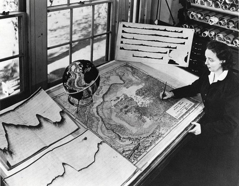
Without ever setting sail, Marie Tharp mapped the ocean floor and made a discovery that shook the foundations of geology. So why did the giants of her field dismiss her findings as “girl talk"?
|

Maps. They’ve been around longer than photographs. They’ve defined empires,guided explorers, told stories, and captured the imagination of many a hopeful traveler for years. While most appreciate the beauty and power of a good map, few recognize the dynamic and vital applications they have today.
Tags: mapping, 201, edtech, cartography. Via Mike Busarello's Digital Storybooks

Rich Schultz's curator insight,
February 11, 2015 11:27 AM
Would an inverted Peters projection "freak you out"? 
Tiani Page's curator insight,
April 27, 2015 11:51 PM
As part of geography education we are required to teach students about different map projections and the rationale for these. This little video puts it quite well. 
Adelaide Parkin's comment,
September 7, 2016 8:52 PM
This is an engaging and funny clip! It is a great resource that could be used in a lessons introduction! for myself i love finding funny little clips that relate to a topic to play at the start of a lesson and then explain to the students what the topic is! Great resource i will be saving for later
Inequality isn't just about money. It's also about information. The lack of reliable data about developing countries makes things like development work and disaster relief much harder.

"Google is using a new technology to automatically generate 3D buildings from 45-degree angle aerial photography made by overlapping passes of aircraft. The aerial photos are combined to create 3D models."

Annenkov's curator insight,
April 16, 2014 12:46 AM
This technology of visualization I would name "3D landscape" 
Mirta Liliana Filgueira's curator insight,
April 16, 2014 8:40 PM
Tecnología para generar imágenes en 3D con Google Earth 
Sid McIntyre-DeLaMelena's curator insight,
May 29, 2014 2:06 PM
Google Earth has made the Earth easier to decipher and examine in a geographical sense of location and place by being able to see multiple layers. This article goes into the 3D designs and usage of aerial photography to create 3D images. |


