

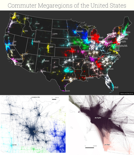
New maps use math to define the amorphous term.
Get Started for FREE
Sign up with Facebook Sign up with X
I don't have a Facebook or a X account


 Your new post is loading...
 Your new post is loading...
Your new post is loading...


PIRatE Lab's curator insight,
December 10, 2016 10:30 AM
Another example is the long line of defining the new geography.

Boris Limpopo's curator insight,
December 11, 2016 1:43 AM
Le macroregioni americane con i dati del pendolarismo

Tom Cockburn's curator insight,
December 13, 2016 3:53 AM
Plenty of space in the middle it seems
Sign up to comment
Mark Cooper-Jones and Jay Foreman, the Map Men, tap into a rich vein of geographical quirks to teach through comedy Via Mike Busarello's Digital Storybooks

Jeremy Hansen's curator insight,
August 29, 2016 12:43 PM
Holy heck these guys are good! I'd like to see more of these Map Men videos. I'm sure at least some of my 8th graders can appreciate some British wit.
From
www

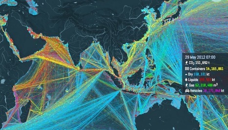
"Ships carry 11 billion tons of goods each year. This interactive map shows where they all go. About 11 billion tons of stuff gets carried around the world every year by large ships. Clothes, flat-screen TVs, grain, cars, oil — transporting these goods from port to port is what makes the global economy go 'round. And now there's a great way to visualize this entire process, through this stunning interactive map from the UCL Energy Institute."

Caitlyn Scott's curator insight,
June 14, 2016 10:25 PM
This resource shows great detail into where are products travel when they are imported but also shows us what and where Australian products are going. Good source in regards to showing how large Australia's export market is. Article contains a good amount of information as to why the routes shown on the map are taken as well as having in-depth data showing the different cargo on board ships. This data helps high light what different countries are renowned for in their exports as well as giving so information into why some countries are poorer than others when analysing their exports. Planned use within unit regarding the cost of Australian exports and its sustainability for the future.

James Piccolino's curator insight,
January 18, 2018 7:35 PM
This is incredibly interesting. I am a History guy, I love the subject and I love finding things I did not know about it. This fun interactive map did not so much contribute to direct knowledge of shipping/trade history as much as it has sparked my interest in it. There are old trade routes, who traveled down them and with what, and the ways those trade routes changed civilization and even sometimes started new ones. I never expected to say the words "Wow trade routes are fun!" but here I am. By the way, if you turn on absolutely everything at once, it creates this beautiful image. It is almost oddly relaxing. Sort of in the way some paintings can be.
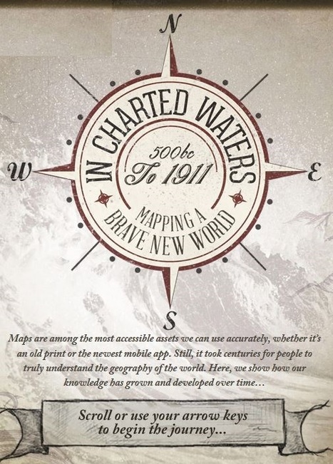
Use our interactive In Charted Waters tool which shows information & visuals on how our knowledge of the world map has evolved. Via Michael Miller, Mike Busarello's Digital Storybooks

Robert Slone's curator insight,
February 25, 2015 7:23 AM
This interactive map is phenomenal teaching tool that would be great for teaching elementary school children introductory geography, 
Samuel Meyer's curator insight,
March 23, 2015 12:00 PM
It is notable that the world's map has changed much since the advent of cartography, and many believed that the Americas were part of Asia. This is represented in the map.

This website serves as an off-campus host for text, images, data and other web-based resources associated with the free eText, Introduction to Human Geography: A Disciplinary Approach.

Leoncio Lopez-Ocon's curator insight,
August 13, 2015 8:52 AM
Gracias a Seth Dixon accedo a este texto de acceso libre que es una interesante Introducción a la Geografía Humana. De fácil navegación se puede acceder a valiosa información textual, a imágenes, datos y otros recursos. Es un producto de Steven Graves, profesor de geografía en California State University, Northridge.

Ask any teenager for directions and he can pull up Google Maps quicker than you can recite an address. Pretty awesome, right? And I’ll be the first to admit that having a map in my phone that not only tells me where to turn but how long it will take me to get there is pretty amazing. I use it all the time, honestly. But even when I’m zoning out and listening to that soothing voice telling me where to turn, I have a mental picture in my head of her directions. And I never realized that my teenage daughter doesn’t have a map in her head, because she’s never really had to use one. Ever. Tags: education, K12, geography education, spatial, mapping.

Cade Johns's curator insight,
August 16, 2015 9:26 PM
I think maps on your phone is great but what about if you get lost and you don't have service on your phone then what are you gonna do?Most young people have never had to read an actual map so most likely they won't be able to find their way back to civilization. CJ 
Ethan Conner's curator insight,
August 17, 2015 8:56 AM
Many people cannot read maps because of technolagy. This new form of maps are keeping children from the traditional way. Also keeping them from education. 
Aaron Burnette's curator insight,
August 26, 2015 9:50 AM
Although cell phone and technology is helpful, other people still believe in the prideful way. Reading paper maps.
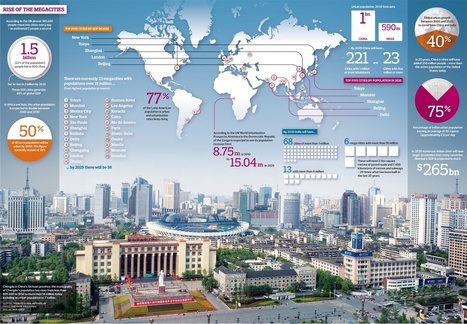
The rapid increase in the number of cities home to more than 10 million people will bring huge challenges … and opportunities...
Via Rachael Long, Mike Busarello's Digital Storybooks

Al Picozzi's curator insight,
September 9, 2013 12:06 PM
More and more people are moving to the cities than ever before. As a result I believe there are more megacities on the way. However I think there is a limit to these cities. How are they going to be powered? How are the people going to be fed? Where will they work? how will these cities impact the environment? Where is all the fresh water going to come from? 
Kenny Dominguez's curator insight,
December 12, 2013 12:26 AM
It is a good thing that there is more megacities being created because you can see more people move in which will help the city function better economics wise. When it comes down to the population that is a different story because there is more people to worry and deal with. The increase of people could go both ways because it can be good but at the same time it can go bad because people will start arguing in which it can get physical which means city ratings going down.
"Mr. Tom is as much a chief technology officer as he is a farmer. Where his great-great-grandfather hitched a mule, 'we’ve got sensors on the combine, GPS data from satellites, cellular modems on self-driving tractors, apps for irrigation on iPhones,' he said. The demise of the small family farm has been a long time coming. But for farmers like Mr. Tom, technology offers a lifeline, a way to navigate the boom-and-bust cycles of making a living from the land. It is also helping them grow to compete with giant agribusinesses." Via Dean Haakenson

BrianCaldwell7's curator insight,
March 16, 2016 3:41 PM
The New York Times article associated with the video above offers a great glimpse into the inner works of how agribusiness technologies have transformed the American family farm.
Tags: agriculture, food production, agribusiness, unit 5 agriculture.

Flo Cuadra Scrofft's curator insight,
March 21, 2015 9:38 PM
This presentation talks about the misconceptions of geography and about what it really involves. Geographers describe and try to explain how locations interact and relate to one another; are arranged the way they are; and have become what they are now. They also use critical thinking to project what the world might look like in the future. As there's usually so many questions that have to be answered, geography is an interdisciplinary work, meaning that it is a blend of natural sciences, social sciences, and humanities. Geographers also develop other skills, such as mapping and graphing (spatial representation skills) and development of verbal concepts, frameworks and mathematical models (spatial theorizing skills). Geography, therefore, can be used to study many issues, such as climate change, sustainability, human rights, among others. Reflection- as the presentation accurately shows, many people believe that geography is just about memorizing countries and our world's natural resources locations, but in reality, geography goes much deeper than that. Geography is about asking questions and trying to come out with the best answers in order to solve issues that can range from local usage of land to international security. 
Gregory Stewart's curator insight,
August 29, 2015 9:37 AM
Prezi created by students interested in the field of geography. 
Alex Smiga's curator insight,
September 7, 2015 4:26 PM
Seth Dixon's insight:
This Prezi was created by students from theSyracuse Geography Department as part of a Senior Seminar to explain the disciple, the major and its utility. This is a great recap of the discipline, the major and it's utility.

"An animated map of global wind and weather. Join the Facebook community. Seen here are the dual menaces, Cyclone Hudhud and Typhoon Vongfong (as seen from ISS)."

Pam Anderson's curator insight,
October 12, 2014 11:48 AM
this might interest some of our teachers who are studying weather With their students. I just think this site is fascinating!
"A 3-minute journey through the last 250 years of our history, from the start of the Industrial Revolution to the Rio+20 Summit. The film charts the growth of humanity into a global force on the equivalent scale to major geological processes."

Courtney Barrowman's curator insight,
May 21, 2015 11:33 AM
Summer reading KQ1: How has the Earth's environment changed over time?
Alex Smiga's curator insight,
March 14, 2016 7:44 PM
Many geologists and other scientists now recognize that we are in a new geologic era. This new era, called the Anthropocene, is distinguished by the fact that one species (homo sapiens), is dramatically modifying the environment. These modifications are impacting geologic processes to such a degree that this time period is geologically distinct (see this remote sensing interactive for examples of environmental change). Paul Crutzen, a Nobel Prize–winning scientist who champions the term Anthropocene declared, “It’s no longer us against ‘Nature.’ Instead, it’s we who decide what nature is and what it will be.” This video is a great primer for discussing the nature and extent of human and environmental interactions as related to industrialization, globalization and climate change. This is definitely one of my favorite resources.
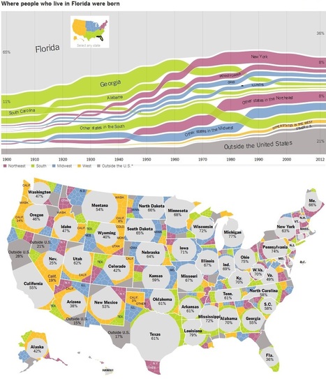
Charts showing how Americans have moved between states for 112 years.

samantha benitez's curator insight,
November 22, 2014 2:51 PM
Charts showing how Americans have moved between states for 112 years. helps show the nature of change around the United States and its impact in the enviorment.
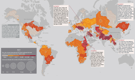
As the climate shifts, rivers will both flood and dry up more often, according to the latest report from the Intergovernmental Panel on Climate Change. Shortages are especially likely in parts of the world already strapped for water, so political scientists expect feuds will become even more intense. To track disputes worldwide, researchers at Oregon State University spent a decade building a comprehensive database of international exchanges—-both conflicts and alliances—over shared water resources. They found that countries often begin disputes belligerently but ultimately reach peaceful agreements. Says Aaron Wolf, the geographer who leads the project, “For me the really interesting part is how even Arabs and Israelis, Indians and Pakistanis, are able to resolve their differences and find a solution.”

J. Mark Schwanz's curator insight,
June 21, 2014 11:01 AM
Add water to geography education curriculum? You better believe it. The crisis of the 21st century is and will be water.
Courtney Barrowman's curator insight,
May 21, 2015 11:36 AM
summer reading KQ2: How have humans altered the Earth's environment? Water Security
James Piccolino's curator insight,
March 24, 2018 10:01 AM
The idea of going to war over water is a scary one, but is still possible in an unfortunate future. After all there must have been a time when going to war over oil was a scary possibility and nothing more. Water being a necessity would surely make it more justified in the minds of many, but would lead to disaster down the line.
|
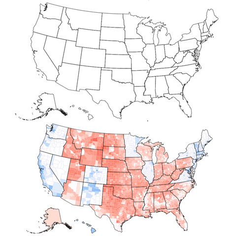
Can you tell what’s wrong with this map of the United States? I’ll give you a hint: Look near the Great Lakes and the Gulf of Mexico. Spot the problem yet? A further hint: Look at the border of Wisconsin and Illinois as well as the Florida Panhandle. See it now? The Wisconsin-Illinois border is slightly more southern and the Florida Panhandle is slightly shorter.

Corey Rogers's curator insight,
December 13, 2018 4:14 PM
The electoral college is such a mess that it shouldn't be relied on for figuring out the President. With the misrepresentation of the map and the continuous gerrymandering the United States should use the popular vote category instead of the Electoral College.

The country opted to become the first ever to leave the 28-member bloc in a result that will send economic and political shockwaves across the globe. Via Mike Busarello's Digital Storybooks

David G Tibbs's curator insight,
February 28, 2018 1:29 PM
With Britain leaving the EU it changes the landscape of Europe. This would be the spark that would light the nationalist fire in Europe. This threatens to break up the supernational organization. This was a massive split in the British politicians.
"My 2015 NESTVAL presentation in an APHG session on the geography of food."

GTANSW & ACT's curator insight,
October 10, 2015 6:09 PM
Things to consider when teaching about food production from a geographical perspective - remember to link to Biomes.
From
vimeo
"In just a few generations, we have tightly restricted American kids' freedom to roam, play, and become self-sufficient. The percentage of children walking and bicycling to school has plummeted from almost 50 percent in 1969 to about 13 percent today. Although distance from school is often cited as the main barrier to walking and bicycling, many families still drive when schools are close to home. According to the Safe Routes to School National Partnership, driving accounts for about half of school trips between 1/4- and 1/2-mile long — which in most cases shouldn't take kids much more than 10 minutes to walk."

asli telli's curator insight,
August 15, 2015 1:34 AM
Also applies to unfortunate Turkey w/her recent urban transformation wave...

When the giant fault line along the Pacific Northwest ruptures, it could be our worst natural disaster ever.
The Cascadia subduction zone remained hidden from us for so long because we could not see deep enough into the past. It poses a danger to us today because we have not thought deeply enough about the future. The Cascadia situation, a calamity in its own right, is also a parable for this age of ecological reckoning, and the questions it raises are ones that we all now face. How should a society respond to a looming crisis of uncertain timing but of catastrophic proportions? How can it begin to right itself when its entire infrastructure and culture developed in a way that leaves it profoundly vulnerable to natural disaster? Via Mike Busarello's Digital Storybooks

David Stiger's curator insight,
September 12, 2018 12:24 PM
Thanks to advancements in technology and dedicated researchers who often forgo glory and fame, Americans are now aware of another impending natural disaster that is likely to ruin the lives of so many of our fellow citizens. This article reminded me of the impending doom of climate change and the resulting ecocide. So many of us, even people who put faith in religion, trust scientific discovery enough to acknowledge that these are realities we face as a society. Not all of us are totally brainwashed to dismiss this a secular, liberal hoax. Despite this awareness, not much - if anything - is being done to address or prepare for the awaiting earthquake and tsunami. This fact affirms that the United States' population is largely out-of-touch with reality. In a fantasy world, like ours, we are too special and superior (perhaps chosen by destiny or God) to suffer such a drastic and radically dreadful experience of nature. The delusion prevents us from acting sooner, rather than later. What comes to mind is the Netherlands as they train their population and renovate their urban centers to flow with the tides of climate change. They have the knowledge (like we do) but the difference is they have embraced it and in a communal way have decided to take action. These Europeans are adapting to their situation. This sheds light on the irony of the United States; a powerful, resource rich, skilled, and highly capable country that is falling a part because of what? Greed for wealth? Selfishness? Dare-I-say foolishness? Maybe it is indifference in an age of modernity - devoid of true human connection but full of technological bliss and distraction? Add the Cascadia subduction zone to modernity's doom list now including unsustainable wealth inequality, overextended military policies, climate change complacency/denial, mass incarceration, obesity, mass shootings, a post-fact world, and an Opioid health epidemic. These are BIG problems that need bold strokes. Simply put, many people with wealth and power do not feel a connection to their countrymen and countrywomen to allow a government - acting on behalf of the masses - to do something. And, that is a key link. Businesses seeking to make a profit do not want regulations and adaptation to interfere. The cost of addressing these problems is a potential loss of money-making as consumers modify their behavior and new policies require more funding through taxes. As this article relates to geography and my aforementioned class-warfare rant: the Earth is indisputably a complex planetary system that has always been totally indifferent to human wants and needs. The planet has no obligation or will to act in our best human interests. We, as a people, must respond to the planet. When it shakes, we must brace or move. In other words, we must take action or experience the consequences of inaction. Crony capitalism, excessive wealth, and a government held hostage by corporate interests which prioritize profit over people are serious hurtles. The wealthy and powerful should realize that they need US - the 90% of people that lack significant amounts of disposable income. 90% is a large chunk of civilization! There is no wealth and prosperity if there is no healthy civilization on which to build a business or exercise entrepreneurial abilities. It is time to confront greed by recognizing our collective humanity - a humanity shaped and informed by geographically determined experiences. 
Kelvis Hernandez's curator insight,
September 29, 2018 7:48 PM
An insightful and honestly, scary article. Discussing the inevitable earthquake that would devastate the pacific northwest, but not knowing when it could occur makes me never want to even visit. The Cascadia earthquake which could or more likely would send a tsunami straight into Oregon. Learning from the Seaside, Oregon superintendent that three of the four schools under his charge will go from five to fifteen feet above sea level to as much as forty-five below would shake anyone to their core. So what has the state done to remedy this? Nothing, unfortunately. With no Early-warning system, he describes how one elementary school will be trapped, as they will have no escape. With the growing ocean waters on one side and a roadless bog on the other, these students have nowhere safe to go. This reminds me of the question, would you rather know how you will die or when you will die? Waiting with no clue when the impending doom will occur until it happens is too much for me. I recommend get out now and get out quick unless the state figures out a warning system, then just get out quick.
Corey Rogers's curator insight,
December 13, 2018 11:00 PM
Yes, we have some serious earthquakes on the San Andres fault and in Japan but we're overlooking the one along the Pacific Northwest. An out roar has to be made for people to be more notified of the Cascadia subduction zone, so people can prepare for tragedy. We need to realize that the way these plates move can make a major ripple effect on our way of life.
"The reason why some countries are rich and others poor depends on the quality of their institutions, the culture they have, the natural resources they find and what latitude they're on."
Tags: development, statistics, economic, globalization, poverty. Via geographynerd, Mike Busarello's Digital Storybooks

Kaitlyn Evans's comment,
July 30, 2015 5:24 AM
I'm not sure if I believe everything this video stated, however I think it is a good topic to analyze. I think it would be interesting to see how the rich countries became rich. They can't just have started on top. I also believe the rich countries abuse the poor countries because we can get goods/minerals/just about anything for a small price and then sell it in the rich country for much more.

Adrian Bahan (MNPS)'s curator insight,
March 14, 2016 7:49 PM
I can't say I agree with all the arguments put forward in this video, it can still be a nice starting point to get students to critically analyze the ideas put forth and assess the merits of the claims being made.
"MyLifeElsewhere allows you to compare your home country with different countries around the world. Ever wonder what your life would be like if you were born somewhere else?" Via Adam Cooke

HG Académie de Rennes's curator insight,
January 31, 2015 1:56 AM
Un site d'une grande simplicité d'utilisation bien qu'en anglais. Le principe est de choisir deux pays dans un menu déroulant pour en comparer les principaux indicateurs de développement sous la forme de petites infographies très pédagogiques. Dernière information sur ce site, les statistiques utilisées proviennent des bases de données open source de la CIA américaine. 
Brian Wilk's curator insight,
February 7, 2015 7:51 PM
After studying this comparison tool and using it to find the best of the best and worst of the worst, I picked out some highlights I'd like to share. Monaco is clearly the place to be born, earn, and live. When compared to the USA, the infant mortality rate is 71% less, the life expectancy is 10 years longer @ 84, and you'll earn 62% more money, no doubt because you have ten more years in which to do so. I believe the stats may be skewed a bit in this country comparison as the very rich live there and they have access to the best medical care, and probably don't have very many infants with them when they make the move from elsewhere, hence the low infant mortality rate. Austria is not a bad second choice as you are 33% less likely to be unemployed. On a sobering note, the life expectancy if you live in Namibia is only 52! Yikes, I'm already 53... It's far worse however in Swaziland. The life expectancy is sadly only 50.5 years and you are 44 times more likely to have AIDS than if you lived here. 26.5% of the population has AIDS! Be thankful for where you live and stop complaining, it's far worse on average in nearly all other countries. 
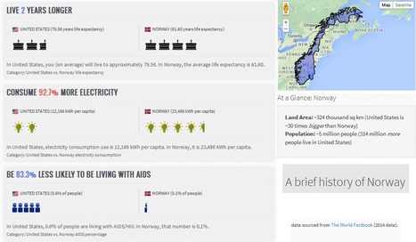
Monika Fleischmann's curator insight,
February 15, 2015 4:59 AM
Seth Dixon's insight:
Did you know that with 1/30th the territory of the United States, Norway still has over 25% more coastline? I didn't either until I compared Norway to the United States using My Life Elsewhere. This site is designed allow United States students to imagine how their lives might be different if they were born in a different part of the world. Students would probably die 21 years earlier if they were born in Liberia and 11 times more likely to have died in infancy. Students would be 43.8% less likely to grow up and be unemployed and have 36.3% less babies if they were born in Taiwan. This side-by-side format is a great way to help students help make these statistics real and meaningful. One major drawback: this site only allows users to compare a country to the United States. If you prefer to have students compare, say Cuba to the United Arab Emirates, I would recommend that you try If It Where My Home.

I have a confession to make; I’m a map geek. Even as a kid watching Raiders of the Lost Ark, I was fascinated by the map they used to segue between scenes to show Indiana Jones’ travels.

Adriene Mannas's curator insight,
December 12, 2014 11:05 AM
Unit 1 Nature and Perspectives of Geography
This article shows that people often still love maps. Some people grow out of map loving as a teenager and it is not as popular for people to like them anymore. This article tells haw maps are being pushed out of style and how it is hurting our intelligence.
This ties into human geography through the fact that it is needed to have a passion for geographical thinking to even get into Human Geography. This shows how not learning about mas can drastically hurt and is drawing away from the geographical field. 
Jason Schneider's curator insight,
January 27, 2015 12:02 AM
I'm taking World Regional Geography because I love maps as well. I am more of a visual learner rather than a verbal learner. In my spare time, I like to map out my dream restaurants and my dream home and turning it into a map itself helps me understand locations in the easiest way. It also helps me identify one area's size and shape in comparison to other's.

"By 2025, the developing world, as we understand it now, will be home to 29 megacities. We explore the latest UN estimates and forecasts on the growth of these 'cities on steroids', and take a look at the challenges and opportunities megacities present for the tens of millions living in Lagos, Mexico City and Dhaka."

Katelyn Sesny's curator insight,
October 31, 2014 11:48 AM
This article asks and answered the question of how and when we will reach a time and place where we live will be limited (as we weigh down the world)? -UNIT 1
Sometimes a single unlikely idea can have massive impact across the world. Sir Harold Evans, the author of They Made America, describes how frustration drove...
Via Maria la del Varrio, Mathijs Booden

Alyssa Dorr's curator insight,
December 7, 2014 5:26 PM
I always enjoyed TED videos. What really struck me was the opening sentence of the video, "everything is everywhere these days." This is so true in so many ways. The video uses different examples that you can find in different stores from places all over the world. How many things can you could in your bedroom that says "Made in China" or some other place other than the US? This is very common as we all know. Products and goods come from all over the world and even over seas. This is a process that we call globalization. However, the video introduces a process called containerization. This process saves an ample amount of time for the workers. The process was a success. "shrinking the world and enlarging human choice." 
Michael Mazo's curator insight,
December 10, 2014 7:48 PM
Globalization has connected the world in such a way that we hadn't thought possible. This idea has created rising economies all over the world and has made transport of goods and services move faster and continues to increase this rate with advances in technology. Containerization is a staple of globalization and without it, none of these products would be able to get from country to country. In essence it has developed the world of import and exports. To add to this success, globalization has also created jobs and communities which revolve heavily around the transport of goods. It saves time by using massive containers to move goods and it creates opportunities in places where it had not been possible before.
BrianCaldwell7's curator insight,
April 5, 2016 8:28 AM
The economies of scale that globalization depends on, relies on logistics and transportation networks that can handle this high-volume. In a word, the container, as mundane as it may seem, facilitated the era within which we live today. This is a very useful video.

Giovanni Sonego's curator insight,
June 19, 2014 4:15 AM
Questa mappa interattiva vi permette, muovendovi sui singoli paesi, di leggere un aggiornamento sulle situazioni di conflitto in tutto il mondo.

Claudine Provencher's curator insight,
June 19, 2014 5:40 AM
This looks like an excellent tool for students of international relations.
Courtney Barrowman's curator insight,
June 23, 2014 12:26 PM
unit 4 --but really a great overall course resource! |


