Human Interest
199.0K views | +4 today
Follow
Human Interest
Your new post is loading...
Rescooped by Skuuppilehdet from Human Geography is Everything!
Scoop.it!

This Sheep Is Mapping The Faroe Islands By Wandering Around With A Camera

This Sheep Is Mapping The Faroe Islands By Wandering Around With A Camera | Human Interest | Scoop.it

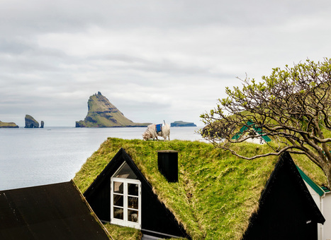
"How do you get Google to visit your small, remote island group with its Street View vehicles, and digitize your roads for the benefit of locals and tourists alike? If you are the Faroe Islands, then you exploit your local resources to roll your own Street View, in the hopes of attracting Google's attention. Behold: Sheep View 360, a solar-powered 360-degree camera, mounted on a sheep's back. Sheep View takes advantage of one great Street View feature: You can upload your own images to Google's service. So Durita Dahl Andreassen, working for the tourist site Visit Faroe Islands, decided to kick-start the Faroe Islands' entry by putting the camera on a sheep and letting it wander free, then uploading the photos."


Via Scarpaci Human Geography
Susan Haskell's curator insight, December 9, 2016 8:32 AM
Excellent career choice for sheep...
Scooped by Skuuppilehdet
Scoop.it!

The Science behind Google Earth

The Science behind Google Earth | Human Interest | Scoop.it

"Google is using a new technology to automatically generate  3D buildings from 45-degree angle aerial photography made by overlapping passes of aircraft.  The aerial photos are combined to create 3D models."

Annenkov's curator insight, April 16, 2014 12:46 AM

This technology of visualization I would name "3D landscape"

Mirta Liliana Filgueira's curator insight, April 16, 2014 8:40 PM

Tecnología para generar imágenes en 3D con Google Earth

Sid McIntyre-DeLaMelena's curator insight, May 29, 2014 2:06 PM

Google Earth has made the Earth easier to decipher and examine in a geographical sense of location and place by being able to see multiple layers. This article goes into the 3D designs and usage of aerial photography to create 3D images.

Scooped by Skuuppilehdet
Scoop.it!

All Maps Are Biased. Google Maps’ New Redesign Doesn’t Hide It.

All Maps Are Biased. Google Maps’ New Redesign Doesn’t Hide It. | Human Interest | Scoop.it

"Google rolled out its new Maps design...from a navigational tool to a commercial interface and offers the clearest proof yet that the geographic web—despite its aspirations to universality—is a deeply subjective entity."

No comment yet.