Human Interest
199.0K views | +0 today
Follow
Human Interest
Your new post is loading...
Scooped by Skuuppilehdet
Scoop.it!

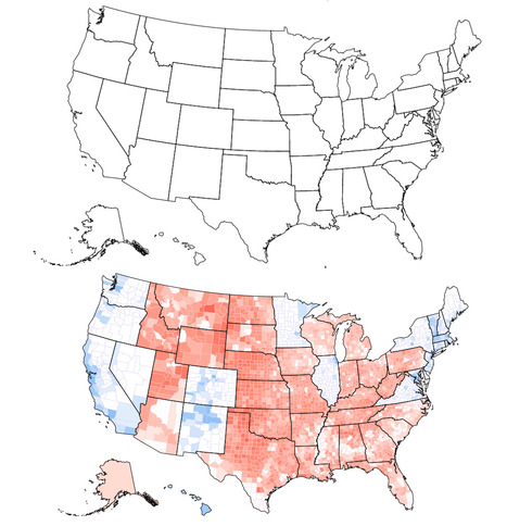
Clinton would have won if the United States looked like the top map

Clinton would have won if the United States looked like the top map | Human Interest | Scoop.it
Can you tell what’s wrong with this map of the United States? I’ll give you a hint: Look near the Great Lakes and the Gulf of Mexico. Spot the problem yet? A further hint: Look at the border of Wisconsin and Illinois as well as the Florida Panhandle. See it now? The Wisconsin-Illinois border is slightly more southern and the Florida Panhandle is slightly shorter.
Corey Rogers's curator insight, December 13, 2018 4:14 PM
The electoral college is such a mess that it shouldn't be relied on for figuring out the President. With the misrepresentation of the map and the continuous gerrymandering the United States should use the popular vote category instead of the Electoral College. 
Scooped by Skuuppilehdet
Scoop.it!

State Borders Were Drawn in the Distant Past. Is It Time to Reimagine Our Map?

State Borders Were Drawn in the Distant Past. Is It Time to Reimagine Our Map? | Human Interest | Scoop.it

"Most state borders were drawn centuries ago, long before the country was fully settled, and often the lines were drawn somewhat arbitrarily, to coincide with topography or latitude and longitude lines that today have little to do with population numbers.  Most state borders were drawn centuries ago, long before the country was fully settled, and often the lines were drawn somewhat arbitrarily, to coincide with topography or latitude and longitude lines that today have little to do with population numbers."


Tags: cartography, mapping, visualizationregions, gerrymandering, political, mapping, census, density.