


Tips from a geographer who's seen it all.
Tags: mapping, cartography, 201, perspective, map.
Via CT Blake
Get Started for FREE
Sign up with Facebook Sign up with X
I don't have a Facebook or a X account


 Your new post is loading...
 Your new post is loading...
Your new post is loading...
Tips from a geographer who's seen it all.
Tags: mapping, cartography, 201, perspective, map. Via CT Blake 

Rich Schultz's curator insight,
February 11, 2015 11:27 AM
Would an inverted Peters projection "freak you out"? 
Tiani Page's curator insight,
April 27, 2015 11:51 PM
As part of geography education we are required to teach students about different map projections and the rationale for these. This little video puts it quite well. 
Adelaide Parkin's comment,
September 7, 2016 8:52 PM
This is an engaging and funny clip! It is a great resource that could be used in a lessons introduction! for myself i love finding funny little clips that relate to a topic to play at the start of a lesson and then explain to the students what the topic is! Great resource i will be saving for later
|
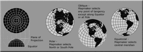
A map projection is used to portray all or part of the round Earth on a flat surface. This cannot be done without some distortion. Every projection has its own set of advantages and disadvantages. There is no "best" projection. The mapmaker must select the one best suited to the needs, reducing distortion of the most important features. Mapmakers and mathematicians have devised almost limitless ways to project the image of the globe onto paper. Scientists at the U. S. Geological Survey have designed projections for their specific needs—such as the Space Oblique Mercator, which allows mapping from satellites with little or no distortion. This document gives the key properties, characteristics, and preferred uses of many historically important projections and of those frequently used by mapmakers today.

Carlee Allen's curator insight,
March 26, 2015 6:58 PM
This article explains and talks about 18 specific map projections. It gives a lot of detail about all of them, and describes the disadvantages and uses for all of them.
I thought that this was interesting because I learned more about map projections, and actually how people use them. 
Leah Hood's curator insight,
August 22, 2017 5:02 PM
This article chronicles 18 map projections, how they are mathematically rendered with their own unique set of advantages and disadvantages. Questions to Ponder: Why do map projections matter? Is one global map projection inherently better than the rest? What is your favorite? Tags: Mapping, visualization, map projections, cartography, perspective. |


A mapping 'take-down' of great detail, with lots of of interesting linked examples