Human Interest
199.0K views | +0 today
Follow
Human Interest
Your new post is loading...
Scooped by Skuuppilehdet
Scoop.it!

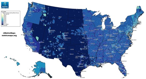
Where ‘speeding’ is legal: A map of maximum limits across the U.S.

Where ‘speeding’ is legal: A map of maximum limits across the U.S. | Human Interest | Scoop.it
An unconventional look at American roads, mapped by their speed limits.


The above map, from MetricMaps, illustrates that abrupt division using local speed limit data.  That map shows the maximum local speed limit for any local roads or highways in each Census block group in the U.S. The nationwide contrasts are striking, but so are the local ones: Zoom in to an individual city like Los Angeles, and the darker arteries effectively outline highways.

Alex Vielman's curator insight, September 20, 2015 10:36 PM

When looking at this map, before looking at the actual index of the colors that determine the speeds, I could already tell which areas would have a higher speed level and which ones had a lower speed level. Looking at the map, the mountain region had higher speed levels. I believe this is accurate because there isn't much going on in this areas. There is tons of land and direct roads that lead to other states. These states, like Wyoming or Montana, aren't really tourist attractions. In the New England area, one could see that the speed levels are lower and I would assume it would be because there are more people in this area. There is not a lot of land here for agriculture. I would say this map seems pretty accurate. 

Raymond Dolloff's curator insight, October 12, 2015 2:13 PM

Speeding in America can lead to some people having road rage because they are in a hurry. However, by looking at the map of speed limits in the United States, the area that would probably see less cases of road rage is in the Central and Plains states that have a speed limit of over 75 miles per hour. This will also help reduce people who speed because they are in a rush to get from point a to point b. In areas such as Rhode Island, where the speed limits reach up to 65 miles per hour, people tend to rush and get angry with people who are going below the speed limit and lead to the need for speed to calm themselves down. Thus, it also includes a higher risk for getting a speeding ticket which will be expensive.

Rescooped by Skuuppilehdet from Stage 4 Interconnections
Scoop.it!

How Pandemics Spread

View Full Lesson on TED-ED BETA: http://ed.ted.com/lessons/how-pandemics-spread In our increasingly globalized world, a single infected person can board a pl...


This is a great demonstration of why spatial thinking is critical to so many fields, including medicine.


Tags: diffusion, medical, historical, spatial.


Via Matthew Wahl, GTANSW & ACT
Miles Gibson's curator insight, November 23, 2014 11:33 AM

Unit 1 nature and perspectives of geography

This video is about how a world wide pandemic can occur and has occurred in history. I thought this was interesting because it  spoke of many specific events like the black death and the 2010 cholera outbreak in haiti, gave detailed information, and was very informal.

This relates to unit 1 because it shows how pandemics and epidemics occur in a detailed way. It also shows how geography has related to epidemic outbreaks by showing disease spread maps and showing how doctors used this to solve the issue of it.

Rescooped by Skuuppilehdet from HMHS History
Scoop.it!

Kids Who Get Driven Everywhere Don't Know Where They're Going

Kids Who Get Driven Everywhere Don't Know Where They're Going | Human Interest | Scoop.it
A new study suggests vehicular travel affects children's ability to navigate their neighborhood and connect to their community.


We learn about the places around us by exploring.  Literally our mental map is formed by making choices (in part through trial and error) and that process strengthens our spatial perception of the neighborhood.  Research is showing that kids with a 'windshield perspective' from being driven everywhere are not able to draw as accurate maps as children for who walk and bike their neighborhood.  The built environment and the transportation infrastructure in place play a role in developing spatial thinking skills for young minds. 


This is a compelling article with some important implications.  What are the ramifications for geographers?  City planners? Educators?  Families moving to a new neighborhood?   


Via Michael Miller
Victoria McNamara's curator insight, December 11, 2013 10:52 AM

We may not realize it but when we take our kids out on drives to run errands or if we move to a different area we are ruining their understanding of the area they live in. Children often have a hard time of figuring out where they are if they constantly in a car looking at new places. This can cause them to lack a sense of direction and maybe have trouble remembering streets or landmarks near their homes. 

Scooped by Skuuppilehdet
Scoop.it!

Children and Space

"In just a few generations, we have tightly restricted American kids' freedom to roam, play, and become self-sufficient. The percentage of children walking and bicycling to school has plummeted from almost 50 percent in 1969 to about 13 percent today. Although distance from school is often cited as the main barrier to walking and bicycling, many families still drive when schools are close to home. According to the Safe Routes to School National Partnership, driving accounts for about half of school trips between 1/4- and 1/2-mile long — which in most cases shouldn't take kids much more than 10 minutes to walk."

asli telli's curator insight, August 15, 2015 1:34 AM

Also applies to unfortunate Turkey w/her recent urban transformation wave...

Scooped by Skuuppilehdet
Scoop.it!

Why 12-Foot Traffic Lanes Are Disastrous for Safety and Must Be Replaced Now

Why 12-Foot Traffic Lanes Are Disastrous for Safety and Must Be Replaced Now | Human Interest | Scoop.it
Let's make "10 not 12!" a new mantra for saving our cities and towns.


[12 foot lanes] are wrong because of a fundamental error that underlies the practice of traffic engineering—and many other disciplines—an outright refusal to acknowledge that human behavior is impacted by its environment.


Tags: transportation, planningspatial, scale.

No comment yet.