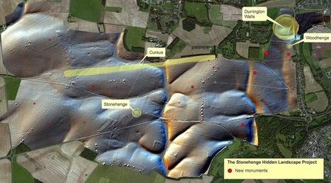

"Every summer solstice, tens of thousands of people throng to Stonehenge, creating a festival-like atmosphere at the 4,400-year-old stone monument. For the 2015 solstice, they will have a bit more room to spread out. A just-completed four-year project to map the vicinity of Stonehenge reveals a sprawling complex that includes 17 newly discovered monuments and signs of a 1.5-kilometre-around ‘super henge’.
The digital map — made from high-resolution radar and magnetic and laser scans that accumulated several terabytes of data — shatters the picture of Stonehenge as a desolate and exclusive site that was visited by few, says Vincent Gaffney, an archaeologist at the University of Birmingham, UK, who co-led the effort."
Tags: Mapping, geospatial, remote sensing, landscape.


 Your new post is loading...