IELTS, ESP, EAP and CALL
18.5K views | +0 today
Follow
IELTS, ESP, EAP and CALL
Interesting links and articles related to IELTS, ESP, EAP and E-learning.  Available to teach ESP, EAP, Research Skills, IELTS, TOEFL and General English.
Curated by Dot MacKenzie
Your new post is loading...
Scooped by Dot MacKenzie
Scoop.it!

Selecting a Map Projection

Selecting a Map Projection | IELTS, ESP, EAP and CALL | Scoop.it
Video. Cartographers at National Geographic discuss how they select an appropriate map projection for the September 2012 magazine map supplement.


There is no one perfect map projection that fits all circumstances and situations. Think a situation in which this map projection would be an ideal way to represent the Earth and another situation where it is an incredibly limited perspective. 


Tags: cartography, K12, geospatial, NationalGeographic, water. 

No comment yet.
Scooped by Dot MacKenzie
Scoop.it!

NCGE webinars

NCGE webinars | IELTS, ESP, EAP and CALL | Scoop.it
The National Council for Geographic Education is a non-profit organization, chartered in 1915 to enhance the status and quality of geography teaching and learning.


Wednesday, Sept. 14th webinar "Navigating the Challenges of Teaching Geography to 9th graders." 

No comment yet.
Scooped by Dot MacKenzie
Scoop.it!

Geomorphology Game

Geomorphology Game | IELTS, ESP, EAP and CALL | Scoop.it

"Kinetic City: Shape It Up"


What forces shape the Earth?  What timeframe is necessary to create these changes?  This is a powerful tool, especially for the elementary school and middle school teachers to use. 

Mr. Twining's curator insight, November 25, 2014 4:11 PM

Geomorphology Game! Short, but very fun game that shows students how landscapes change over time and from a variety of geomorphological processes. This game could be really fun at any grade level I think. For older students it's really good to see how the same type of erosion, but over a longer time period can change the landscape even more.

Scooped by Dot MacKenzie
Scoop.it!

How Big is my World?

This type of mapping project is a fantastic way to teach scale to elementary school students. 

No comment yet.
Scooped by Dot MacKenzie
Scoop.it!

IKAAW LAND Online Map Game

IKAAW LAND Online Map Game | IELTS, ESP, EAP and CALL | Scoop.it

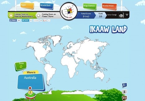
"Learning Geography was never this easy. With the interactive Ikaawland Map Quiz, You can put your trivia knowledge to test in our game based on Maps. Different levels are presented infront of a player. In the whole game, the player has to mark answers on World Map. At the first level, the user is presented with questions , where he/she has to mark out the continents asked in the quiz. The player is given 10 seconds on each question to mark the correct location on the mapSimilarily, in the consequent levels, the player faces questions(quiz) related with countries, capitals, cities. More levels have been planned and would launch soon.


We offer exciting and educative games which revolve around Maps. The game enable players to learn varied concepts of Geography through quizzes. Other quiz/ games from Maps of World are Save Earth Quiz, Know your World Quiz, Jigsaw Puzzle Game and World Quiz, Map 'O' Puzzle." 


To read the article, click: http://trap.it/tvAdvB to see the game, just click on the image. 

No comment yet.
Scooped by Dot MacKenzie
Scoop.it!

Kid World Citizen

Kid World Citizen | IELTS, ESP, EAP and CALL | Scoop.it

"Activities that help young minds go global."


This website is especially good for elementary school teachers that are looking for ways to globalize their students educational experiences.  They have activities and resources that are regionally organized--check it out! 

No comment yet.
Scooped by Dot MacKenzie
Scoop.it!

100 People: A World Portrait

100 People: A World Portrait | IELTS, ESP, EAP and CALL | Scoop.it

This is the truly global project that asks the children of the world to introduce us to the people of the world.  We've seen videos and resources that ask the question, "if there were only 100 people in the world, what would it look like?"  This takes that idea of making demographic statistics more meaningful one step further by asking student in schools for around the world to nominate some "representative people" and share their stories.  The site houses videos, galleries from each continent and analyze themes that all societies must deal with.  This site that looks at the people and places on out planet to promote greater appreciation of cultural diversity and understanding is a great find. 


Tags: Worldwide, statistics, K12, education, comparison.

Sarah Quick - Geographer's curator insight, September 1, 2013 10:43 PM

Year 7 Liveability Unit 2

savvy's curator insight, September 3, 2014 12:57 PM

This just makes me realize how the world would be if we only had 100 people rather than the billions we have now.

Luis Cesar Nunes's curator insight, February 26, 2015 7:24 AM

A face das crianças no mundo

Scooped by Dot MacKenzie
Scoop.it!

Earth from Above

Earth from Above | IELTS, ESP, EAP and CALL | Scoop.it

I'm a huge fan of Yann Arthus-Bertrand's artistic aerial photography.  This image of Rio de Janeiro and the favela is a striking one. I am also posting this to show the how easy the website justpaste.it is to use.  Students with no website creation training can produce sharable materials online.  Now this isn't the most professional outlet, but I envision some middle school or high school students producing a class project that can be transformed into something that reaches a bigger audience as it is shared with a broader community. 


Tags: remote sensing, images, art, worldwide, K12, edtech.

No comment yet.
Rescooped by Dot MacKenzie from iGeneration - 21st Century Education (Pedagogy & Digital Innovation)
Scoop.it!

9 Excellent Free Map Creation Tools for Teachers and Students

9 Excellent Free Map Creation Tools for Teachers and Students | IELTS, ESP, EAP and CALL | Scoop.it

Via Tom D'Amico (@TDOttawa)
No comment yet.
Rescooped by Dot MacKenzie from iGeneration - 21st Century Education (Pedagogy & Digital Innovation)
Scoop.it!

MIT Video - More Than 10,000 Educational Videos

MIT Video - More Than 10,000 Educational Videos | IELTS, ESP, EAP and CALL | Scoop.it

Via Tom D'Amico (@TDOttawa)
No comment yet.
Scooped by Dot MacKenzie
Scoop.it!

United States MapMaker Kit

United States MapMaker Kit | IELTS, ESP, EAP and CALL | Scoop.it
MapMaker Kit. Download, print, and assemble maps of the United States in a variety of sizes. The mega map occupies a large wall, or can be used on the floor.


Have you every wanted to create a giant map but aren't sure if you can logistically pull it off?  The National Geographic's MapMaker kit is just that, a kit for you to create wall maps from a standard printer and tile them together.  The assembly itself is a great spatial thinking and fun exercise for students (and there are large world maps as well). 


Tags: NationalGeographic, cartography, mapping, K12.

No comment yet.
Scooped by Dot MacKenzie
Scoop.it!

Perplexus - The Best Spatial Toy

Perplexus - The Best Spatial Toy | IELTS, ESP, EAP and CALL | Scoop.it

This is the best 3-D maze I've ever seen...kids of all ages love it (I really am just a kid at heart).  But for geography teachers, this maze gets people to use spatial cognition to understand the overall pattern.  For tactile students, this is a great item to have in a classroom. 

No comment yet.
Rescooped by Dot MacKenzie from CORPORATE SOCIAL RESPONSIBILITY –
Scoop.it!

Sustainability explained through animation

Watch this short animated movie explaining sustainability created for RealEyes by Igloo Animations...


Via pdjmoo
No comment yet.
Scooped by Dot MacKenzie
Scoop.it!

World Atlas with Geography Facts, Maps, Flags

World Atlas with Geography Facts, Maps, Flags | IELTS, ESP, EAP and CALL | Scoop.it
World Atlas is an educational resource for world maps, atlases, and in-depth geography information. Teachers and students: free maps of Europe, USA, Canada, Florida, Caribbean Islands and much more.


This World Atlas, in addition to have many maps at a variety of scales as is very common these days, has the added feature of embedding facts and other informative features based on your scale and regional context.  Students can explore this at their own pace to learn about what every region of the world that interests them the most.

No comment yet.
Scooped by Dot MacKenzie
Scoop.it!

Understanding Population Pyramids

This covers what a population pyramid is, and how to analyze one. It covers the three basic shapes and how they correspond to population growth or decline.


Simple introduction on how to analyze population pyramids.   Update: some these slides originally came from a different presentation, which has since been revised.

Miles Gibson's curator insight, December 18, 2014 11:15 AM

Unit 2 Population and Migration

This diagram is an 18 slide powerpoint explaining the uses of, how to analyze, and what a population pyramid shows. This is also in a childish language and is very easy to understand making it an easy thing to use and visualize. It shows how pyramids show fertility rates migration and workforce.

This diagram powerpoint relates to unit 2 because it shows population pyramids with population and migration data on them referencing to the units core concepts. This delves deep into the understanding of the uses of population diagrams overall and their effects on society's parts, It is overall a major part of unit 2.

Ross Mackay's curator insight, March 8, 2016 12:28 AM
Different shapes and implications US focussed
Rescooped by Dot MacKenzie from Remote Sensing News
Scoop.it!

Using satellite images, young students learn about human impact on environment

Using satellite images, young students learn about human impact on environment | IELTS, ESP, EAP and CALL | Scoop.it

With the help of satellite images fifth and sixth grade students at Mr. Tim Blum’s geography class at the University of Wyoming Lab School got a birds-eye view of how humans have impacted or modified their environments. Images acquired by satellites decades apart showed cleared forests, irrigated crop fields in the middle of the deserts, altered landscapes (new roads and water bodies), and urban growth.


SD: Geospatial technologies can sound daunting for teachers that don't feel that they are specialists. Yet there are simple ways to make sophisticated technologies very relevant to just about any grade level as this article demonstrates. 


Via Elpidio I F Filho
joachim jake layes's curator insight, February 10, 2014 9:44 AM

great to see 5th & 6th graders learning about environmental impact

Scooped by Dot MacKenzie
Scoop.it!

Global Closet Calculator

Global Closet Calculator | IELTS, ESP, EAP and CALL | Scoop.it

The Global Closet Calculator aggregates the contents of your closet by origin to generate a map showing your unique global footprint, and puts you in charge of the global journey your stuff takes to get to you.


As I've worked now with the Rhode Island Geography Education Alliance, I've had the good fortune to interact with the folks at National Geographic.  They are preparing for Geography Awareness Week (Nov 11-17th) with the theme "Declare your Interdependence!"  This newly released interactive feature allows students of all ages to see the global interconnections in their lives.   By analyzing the items in our closets (or any of the items that we consume), we can easily see that  our own personal geographies create a web of global interconnectedness.


Tags: NationalGeographic, GeographyEducation, K12, consumption, globalization. 

Brittany Ortiz's curator insight, September 10, 2014 3:16 PM

A fun way for people to interact with there online closet and see how the world ties into our clothes!!

Scooped by Dot MacKenzie
Scoop.it!

Tour the States - Music Video

Full album: http://www.marblesthebrainstore.com/brain-beats Music by Renald Francoeur Drawing by Craighton Berman "Tour the States" is track #1 from Brain Beats, a mnemonic CD...


It’s so often stated that geography education is so much more than just learning states and capitals. I wholeheartedly endorse that sentiment, but there is still some rudimentary importance to learning about where places are. I see it as analogous for English majors needing to learn basic grammar. You can’t write a masterpiece if you are still fumbling around with the alphabet. In geography, we can't have a nuanced discussion of place and interconnectedness if we have no sense of where any place actually is.


Tags: USA, K12, video, GeographyEducation.

Gillian & Alexis's curator insight, November 27, 2013 5:11 PM

A great, to-the-point video showing the political geography of the United States. Quick and fast facts on the 50 states and capitals made into a catchy song! Chosen for poltical geography content. TOPIC: Geography-Location

Rescooped by Dot MacKenzie from iGeneration - 21st Century Education (Pedagogy & Digital Innovation)
Scoop.it!

Maryland Learning Object Repository - currently free to all

Maryland Learning Object Repository - currently free to all | IELTS, ESP, EAP and CALL | Scoop.it

Via Tom D'Amico (@TDOttawa)
No comment yet.