IELTS, ESP, EAP and CALL
18.5K views | +0 today
Follow
IELTS, ESP, EAP and CALL
Interesting links and articles related to IELTS, ESP, EAP and E-learning.  Available to teach ESP, EAP, Research Skills, IELTS, TOEFL and General English.
Curated by Dot MacKenzie
Your new post is loading...
Scooped by Dot MacKenzie
Scoop.it!

Selecting a Map Projection

Selecting a Map Projection | IELTS, ESP, EAP and CALL | Scoop.it
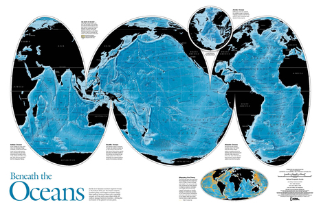
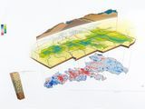
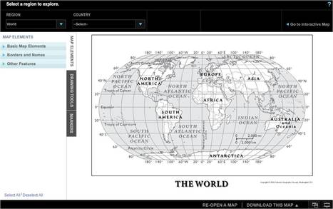
Video. Cartographers at National Geographic discuss how they select an appropriate map projection for the September 2012 magazine map supplement.


There is no one perfect map projection that fits all circumstances and situations. Think a situation in which this map projection would be an ideal way to represent the Earth and another situation where it is an incredibly limited perspective. 


Tags: cartography, K12, geospatial, NationalGeographic, water. 

No comment yet.
Scooped by Dot MacKenzie
Scoop.it!

United States MapMaker Kit

United States MapMaker Kit | IELTS, ESP, EAP and CALL | Scoop.it
MapMaker Kit. Download, print, and assemble maps of the United States in a variety of sizes. The mega map occupies a large wall, or can be used on the floor.


Have you every wanted to create a giant map but aren't sure if you can logistically pull it off?  The National Geographic's MapMaker kit is just that, a kit for you to create wall maps from a standard printer and tile them together.  The assembly itself is a great spatial thinking and fun exercise for students (and there are large world maps as well). 


Tags: NationalGeographic, cartography, mapping, K12.

No comment yet.
Scooped by Dot MacKenzie
Scoop.it!

7 Billion, National Geographic Magazine

See photos from 7 Billion: http://bit.ly/hhYz3m With the worldwide population expected to exceed seven billion in 2011, National Geographic magazine offers a...


This video provides excellent material for discussing population growth, space and sustainability.

Samuel D'Amore's curator insight, December 17, 2014 5:03 PM

The increase in global population is definitely a hot button topic in today's world. Many wonder if the planet will be able to really sustain so many new people, and if it can truly sustain our current number of humans. This video does a good job of addressing these problems and presenting how things will likely come to be. Our planet is capable of producing great amounts of food and material the real hurdle comes down to how well nations will cooperate. Unfortunately politics and money seem to be the real snagging point in the distribution of aid and resources to many.  

Kristin Mandsager San Bento's curator insight, May 1, 2015 4:25 PM

The rapid growth occurring is staggering.  I believe we do need to start thinking about the future in generations.  Where will we be in 50-100 years and where do we need to be.  So basically you need to start thinking about your childrens' childrens' future.  We need to make changes to sustain the increase in population.  

Erin McLeod's curator insight, August 6, 2015 10:55 PM

Geography - Human Population in senior school

Scooped by Dot MacKenzie
Scoop.it!

GIS - National Geographic Education

GIS  - National Geographic Education | IELTS, ESP, EAP and CALL | Scoop.it
Encyclopedic entry. A geographic information system (GIS) is a computer system for capturing, storing, checking, and displaying data related to positions on Earth’s surface. GIS can show many different kinds of data on one map.


This informative webpage (and accompanying features) simply answer the question, "What is GIS and how is it a useful way to work with spatial data?" 

Pau T.'s curator insight, November 2, 2014 5:39 PM

Què és un sistema d'infromació geogràfica (SIG/GIS)?

Scooped by Dot MacKenzie
Scoop.it!

Photo of the Day-Iguazu Falls

Photo of the Day-Iguazu Falls | IELTS, ESP, EAP and CALL | Scoop.it
See a photo of Iguazu Falls in South America and download free wallpaper from National Geographic.


Beautiful image!  South America's equivalent to the Niagara Falls is a place that students should see.

James Hobson's curator insight, September 29, 2014 10:12 PM

(South America topic 3)

What a perfect photo for "National Geographic"! As is the case with many of its other cover or insert photos, it shows what many have seen before (or similar to it), includes a human element in some way, but is taken from an unusual angle or distance. As another example of the pattern I'm noticing, I took a random National Geographic off my bookshelf. The cover shows the Statue of Liberty (a well-known landmark), Manhattan skyscrapers (the human element), but as would be seen from underwater (the unusual perspective). It's something about seeing something familiar from an unfamiliar perspective that makes one stop and reimagine the scope of whatever it is they have experienced.

Tanya Townsend's curator insight, October 30, 2015 10:40 PM

what a beautiful view of South America...

Olivia Campanella's curator insight, September 26, 2018 10:56 AM
This beautiful photo of the Iguazu Falls on the border of Misiones Province in Argentina is beyond breath-taking. 
Scooped by Dot MacKenzie
Scoop.it!

Video -- Dive into the Deep

Video -- Dive into the Deep | IELTS, ESP, EAP and CALL | Scoop.it
March 26, 2012—In a state-of-the-art submersible, National Geographic explorer-in-residence and filmmaker James Cameron reached the deepest point of the Mariana Trench, breaking a world record for the deepest solo dive.


For those who haven't been following National Geographic news, James Cameron (director of "Titanic" and "The Abyss") entered a submarine named DEEPSEA CHALLENGER, and dove to the bottom of the Mariana Trench, the deepest point on Earth. Enjoy this video describing this "lunar-like" environment that is so deep it is lightless and near lifeless with extreme pressure. For more on the expedition, read: http://news.nationalgeographic.com/news/2012/03/120326-james-cameron-mariana-trench-challenger-deepest-lunar-sub-science/

Brett Sinica's curator insight, December 10, 2013 5:06 PM

When the show South Park has made an entire episode based around you, you've certainly done something extraordinary.  James Cameron not only risked his life,  but proved a point and set a new standard in underwater exploration.  In a way, he literally went to the bottom of the earth, something that has been a mystical feat until now.  With technology advancing so quickly and people constantly pushing limits and standards it makes us wonder what will be discovered next.

Ryan Amado's curator insight, December 11, 2013 5:45 AM

It is mind boggling how much of our oceans are still to be discovered. Cameron's journey here is one that needs to be taken all over the world. We have more ocean that is unexplored than explored.  We may also find some answers to fundamental questions to human existence if we are able to research the deep sea more effectively.  It is hard to believe we have been able to research 36,000 feet below and still have more questions than answers. 

Jacob Crowell's curator insight, December 15, 2014 4:44 PM

This is a really cool video, the pressure that exist at the bottom of the ocean has kept humans trapped above a certain depth. Today technology has let us explore areas that have been off limits in the past. Letting an influential filmmaker like Cameron do this is a way to raise awareness about these expeditions to the pop culture obsessed audiences around the world.

Scooped by Dot MacKenzie
Scoop.it!

Geo-Literacy

Geo-Literacy | IELTS, ESP, EAP and CALL | Scoop.it

The Rhode Island Geography Education Alliance seeks to promote geo-literacy here in the Ocean State.  So what is geo-literacy? The National Geographic Society’s Educational team...


As the Alliance Coordinator for the state of Rhode Island, I organized  these three videos (two from National Geographic) and some pictures to provide a basis for understanding what geo-literacy is and why it is important for society and within the workforce.  In the spirit of sharing, I thought I'd share these links beyond the borders of Rhode Island. 


Tags: GeographyEducation, NationalGeographic, geo-inspiration, RhodeIsland.

No comment yet.
Scooped by Dot MacKenzie
Scoop.it!

MapMaker-National Geographic Education

MapMaker-National Geographic Education | IELTS, ESP, EAP and CALL | Scoop.it
Customize one-page maps and download, email, print, or share!


Want to make a custom map don't have a cartographic background or access to GIS software?  This online program will give you what you need. 

No comment yet.
Scooped by Dot MacKenzie
Scoop.it!

MapMaker Interactive - National Geographic Education

MapMaker Interactive - National Geographic Education | IELTS, ESP, EAP and CALL | Scoop.it
Use our tools to explore the world, learn about human and physical patterns, and make your own maps.


This is an excellent online resource to allow student to create thematic maps without GIS software.  

No comment yet.
Scooped by Dot MacKenzie
Scoop.it!

The City Solution - Pictures, More From National Geographic Magazine

The City Solution - Pictures, More From National Geographic Magazine | IELTS, ESP, EAP and CALL | Scoop.it
Why cities are the best cure for our planet's growing pains...


Debate the merits of this quote from Edward Glaeser: "There's no such thing as a poor urbanized country; there's no such thing as a rich rural country."  Is this true?  Are there exceptions?  What explains these geographic patterns?  Is there a causal link between urbanization and economic development? 

No comment yet.
Rescooped by Dot MacKenzie from Geography in the classroom
Scoop.it!

Megacities @ National Geographic Magazine

Megacities @ National Geographic Magazine | IELTS, ESP, EAP and CALL | Scoop.it

By 2030, 2 out of 3 people will live in an urban world, with most of the explosive growth occurring in developing countries. For a review of the future, the last in the Challenges for Humanity series explores São Paulo, Lagos, Bangkok and Hyderabad.


Via dilaycock
No comment yet.
Scooped by Dot MacKenzie
Scoop.it!

Global Closet Calculator

Global Closet Calculator | IELTS, ESP, EAP and CALL | Scoop.it

The Global Closet Calculator aggregates the contents of your closet by origin to generate a map showing your unique global footprint, and puts you in charge of the global journey your stuff takes to get to you.


As I've worked now with the Rhode Island Geography Education Alliance, I've had the good fortune to interact with the folks at National Geographic.  They are preparing for Geography Awareness Week (Nov 11-17th) with the theme "Declare your Interdependence!"  This newly released interactive feature allows students of all ages to see the global interconnections in their lives.   By analyzing the items in our closets (or any of the items that we consume), we can easily see that  our own personal geographies create a web of global interconnectedness.


Tags: NationalGeographic, GeographyEducation, K12, consumption, globalization. 

Brittany Ortiz's curator insight, September 10, 2014 3:16 PM

A fun way for people to interact with there online closet and see how the world ties into our clothes!!