 Your new post is loading...
Not every state is equally impacted by migration, and the demographic profile of migrants is different for every state. This is an online mapping tool to search a large database that can give the user state specific information about the impact of economics and politics based on migration from Latin America and Asia on any given state. Tags: Immigration, unit 2 population, migration, economic, statistics, mapping, political.
In the dusty triangle where Afghanistan, Iran and Pakistan meet, there is more than one war going on. Geopolitically, there is a fascinating confluence of competing interests at this border. This is "the scariest little corner of the world." It's a dangerous place that is often beyond the authority of any of state. It also represents (depending on how you divide the world up) at the intersection of the three major regions in the area: Central Asia, the Middle East and South Asia. Tags: Afghanistan, political, borders, MiddleEast, SouthAsia, Central Asia, unit 4 political.
"It may seem surprising, but in this age where geographic mobility and instant communication have increased our exposure to people outside of our neighborhoods or towns, American regional dialects are pulling further apart from each other, rather than moving closer together. And renowned linguist William Labov thinks there’s a connection between political and linguistic segregation. "Labov suggests that it’s these deep-seated political disagreements that create an invisible borderline barring the encroachment of Northern Cities Vowels. When he looked at the relationship between voting patterns by county over the last three Presidential elections and the degree to which speakers in these counties shifted their vowels, he found a tight correlation between the two. And the states that have participated in the vowel shift have also tended to resist implementing the death penalty. "Social identities are complex, and can be defined along a number of different dimensions like class, race, or ethnicity. Not everyone feels that politics are a part of their core identity. But I suspect that political ideology may become an anchor for accents to the extent that large social groups collectively identify themselves by their political beliefs. According to Bill Bishop, author of The Big Sort, this is happening more and more as Americans voluntarily cluster themselves into homogenous, politically like-minded communities."
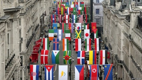
Discover the number of countries participating in the 2012 Summer Olympic Games in London. Find out which countries are not participating in the Olympic Games and learn which non-countries are participating as well. 204 countries are participating in the Olympics? There aren't even 204 countries in the world! This article looks at the political geography of international recognition. One interesting case not discussed in the article is that of Taiwan. Taiwan is participating, but marched under a non-Taiwanese flag under the name Chinese Taipei because the IOC wanted the mainland Chinese to return to the games. Also, South Sudan, Kosovo and the Vatican are not participating (although pondering them competing, especially the Vatican, is something that deeply amuses me). Another intriguing thought: how many of the participants were former British colonies? There are more classroom resources based on the Olympics from the GA.
TED Talks A clay cylinder covered in Akkadian cuneiform script, damaged and broken, the Cyrus Cylinder is a powerful symbol of religious tolerance and multi-culturalism. At first glance this TED Talk appears to be more about ancient history, archaeology and biblical studies that anything modern. Yet as Neil MacGregor, the Director of the British Museum continues his discussion of the Cyrus Cylinder (A clay cylinder covered in Akkadian cuneiform script), it becomes clear that this historical artifact is vital in understanding how modern states conceive of their heritage, cultural legacy and role within the Middle East today (such as Israel, Iraq, Iran and even the U.K.). As such the Cyrus Cylinder is a powerful symbol of religious tolerance and multi-culturalism and plays a role in shaping Middle Eastern cultural and political institutions.
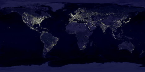
NASA's Visible Earth catalog of NASA images and animations of our home planet... This classic image is full of classroom applications. The first impulse of most students is to note that this image will show us where people live, where the cities are or some other comment that speaks to the magnitude of the population in the white areas. Let them analyze this for more time, and they'll notice that population isn't the whole story of this image. A place like India shines, but less brightly than the eastern part of the United States. I like to point out that South Korea appears to be an island (because North Korea is literally blacked out). Politics, development, affluence and population information are all embedded in this image. As with all maps, the more information you have about the place in question (in this case, Earth), the more meaningful information you can extract out of the map. Tags: remote sensing, worldwide, consumption, poverty, population, spatial, political, regions.
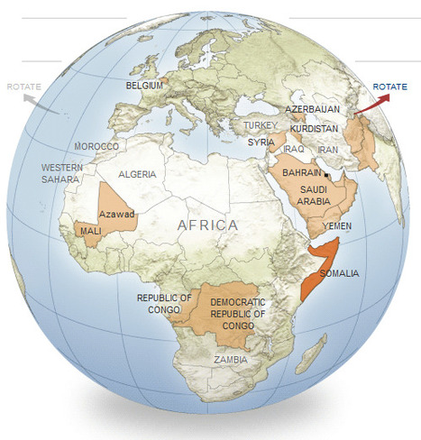
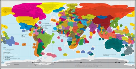
An interactive series of maps show possible new additions to the world’s list of independent nations. This is great way to show examples of devolution and political instability. Included are 11 potential scenarios where further fragmentation/disintegration might occur or even greater regional integration that would redraw the map. These case studies include: Somalia, Korea, Azerbaijan, Belgium and the Arabian Gulf Union. Tags: political, devolution, supranationalism, war, autonomy, unit 4 political.
|
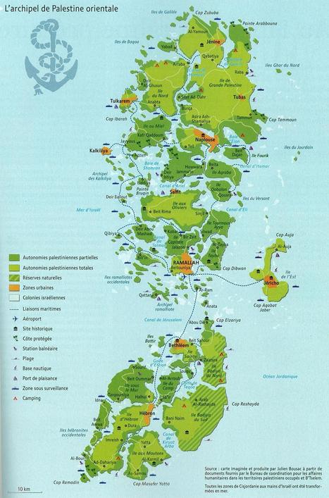
The shape of a state can greatly impact the political cohesion of a country as well as it's economic viability. While this is obviously a fictitious map, it draws our attention to the logistic difficulties that confront Palestine with the Israelis controlling crucial transportation access points and corridors. Questions to Ponder: How is this a 'persuasive map?' What are some of the geographic impacts of this fragmentation on Palestine? For Israel? Tags: cartography, MiddleEast, political, states, territoriality, unit 4 political.
Tags: Middle East, political, states, perspective, unit 4 political.
Via Seth Dixon
KONY 2012 is a film and campaign by Invisible Children that aims to make Joseph Kony famous, not to celebrate him, but to raise support for his arrest and set a precedent for international justice. This needs to be included for many reasons. 1) The geopolitical problem of child soldiers and endemic warfare in Sub-Saharan Africa needs to be analyzed from a spatial and geographic perspective. 2) The social media aspects of this campaign highlight many of the traits of globalization and is a major online movement right now. 3) This would be a perfect opportunity to have a political activist moment in your class (seriously, who isn't opposed to mass murder?). 4) We can teach our classes that geographers are not just going to learn about all the crap that is wrong with our Earth...we are going to fix it and use our resources to improve the human condition. For a cultural analysis of the this video, see this NPR article. Yes the video is filled with oversimplifications and a poor cultural lens, but it has started a conversation and a conversation with students that I feel is worth having. http://www.npr.org/blogs/thetwo-way/2012/03/08/148235430/while-controversial-kony-2012-has-put-focus-on-atrocities The site mentioned in the video is: http://www.invisiblechildren.com For my cultural musings on the video, see the comments section.
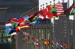
This is the site for the United Nations at a Glance. Here you will find information and links on history, members, visitis, employement and other details. While some critize the ineffectiveness of the organization, the United Nations remains a key organization to get understanding modern geopolitics. Through their UN voting patterns, we can assess the geopolitical motivations, interests and alliances of member states. Also, initiatives (whether successful or not) and highlight the important issues of the day that globally aware students should understand.
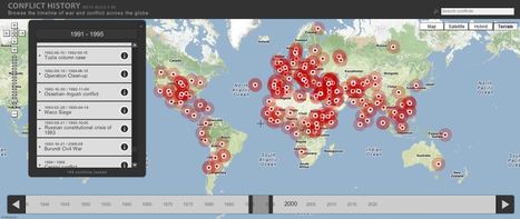
Browse the timeline of war and conflict across the globe. This database of global wars and conflicts is searchable through space and time. You can drag and click both the map and timeline to locate particular battles and wars, and then read more information about that conflict. This resource would be a great one to show students and let them explore to find what they see as interesting. This site is brimming with potential.
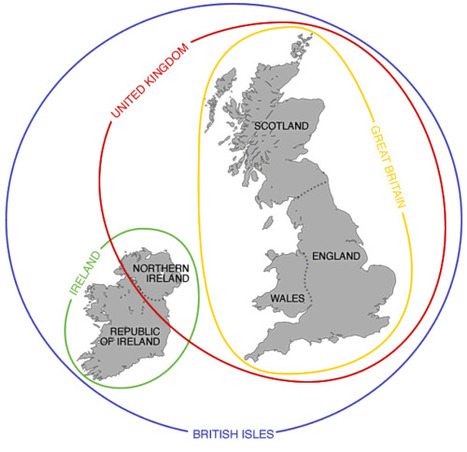
This is the short version of the differences between these interrelated places and terms; the long version is much more complicated than this. Tags: Europe, political, unit 4 political, states, toponyms.
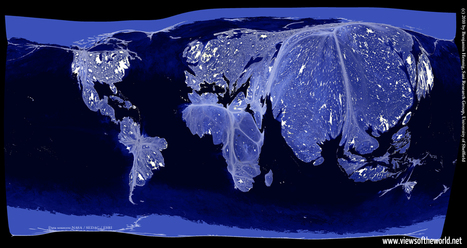
Earlier I have posted the classic image of "Earth Lights at Night," and discussed the classroom uses of the image. This cartogram helps take that analysis one step further. This cartogram helps students to visualize the magnitude of population (with the cartogram adjusting area for population) and then to see the patterns of energy use, global consumption and urbanization with in a new light. Tags: remote sensing, worldwide, consumption, poverty, population, spatial, political, regions.
Today, a country’s marine economic area is defined by its Exclusive Economic Zone (EEZ), a 200-nautical mile-wide (370 km) strip of sea along the country’s national coast line (hi-res image). This regulation, which was installed by the ‘UN Convention on the Law of the Sea’ in 1982, grants a state special rights to exploit natural (such as oil) and marine (for instance fish) resources, including scientific research and energy production (wind-parks, for example). Questions to ponder: how does this series of buffer zones around the Earth's land masses impact politics, the environment and local economies? Where might the EEZs be more important to the success of a country/territory than other regions? Tags: economic, environment, political, resources, water, sovereignty, coastal, environment depend, territoriality, states, conflict, unit 4 political.
|


Unit 2 population and migration
This map shows the population of migrants in certain states and compares them to other states. This demographic specifically highlights Texas and shows its migrant information. Texas has the highest immigrant income out of all of the states. Also Texas has very few naturalized citizens who used to be an immigrant.
This map relates to unit 2 because it shows the illegal immigration. And immigration theories. This proves ravensteins laws correct because it shows how people move a short distance to migrate, knowing that most migrants to America come from Latin America. This map is a great example of ravensteins theories and unit 2