IELTS, ESP, EAP and CALL
18.5K views | +0 today
Follow
IELTS, ESP, EAP and CALL
Interesting links and articles related to IELTS, ESP, EAP and E-learning.  Available to teach ESP, EAP, Research Skills, IELTS, TOEFL and General English.
Curated by Dot MacKenzie
Your new post is loading...
Scooped by Dot MacKenzie
Scoop.it!

Archeology from Space

TED Talks In this short talk, TED Fellow Sarah Parcak introduces the field of "space archeology" -- using satellite images to search for clues to the lost sites of past civilizations.


The uses of geospatial technologies is NOT limited to studying geography, but it is the bedrock of many research projects that involve spatial thinking (as demonstrated in this TED talk).  Geographic principles and geographers can be very important  members of interdisciplinary teams.


Tags: spatial, remote sensing, geospatial, TED, MiddleEast, historical. 

Joshua Lefkowitz's curator insight, January 15, 2014 11:13 PM

This sounds really intruging to me; I have heard of astroarchiology before in the aplication of finding undiscovered large objects (cities, towns sttlements) by using satellites to map deviations in teh earths surface accurately enough to distingush structures like a building foundation. I just find this sort of thing fascinating. I am still in awe that this dort of thing is possible.

Scooped by Dot MacKenzie
Scoop.it!

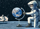
Save the Endangered Globe

Save the Endangered Globe | IELTS, ESP, EAP and CALL | Scoop.it
What’s lost when we lose sight of globes?


While I love digital images, sometimes a sturdy old fashioned three-dimensional globe is just what is needed.  As the article laments, they are becoming increasingly rare. 

No comment yet.
Scooped by Dot MacKenzie
Scoop.it!

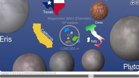
The Scale of the Universe

The Scale of the Universe | IELTS, ESP, EAP and CALL | Scoop.it
Zoom from the edge of the universe to the quantum foam of spacetime and learn about everything in between.


Click "Start," and then use the slider across the bottom, or the wheel on your mouse, to zoom in -- and in and in and in... or out and out and out... It will take you from the very smallest features postulated by scientists (the strings in string theory) to the very largest (the observable universe). This really is a fabulous visual demonstration of scale at micro and macro levels. This is an excellent way to bring spatial thinking into the math curriculum as well.


Tags: Scale, perspective, space, spatial, Unit 1 GeoPrinciples.

Joe Andrade's curator insight, July 7, 2013 10:08 PM

This is a great method of teaching some of the principals behind understanding spatial analysis. An important skill in understanding the world we live in.

Scooped by Dot MacKenzie
Scoop.it!

The Real World at Night

The Real World at Night | IELTS, ESP, EAP and CALL | Scoop.it

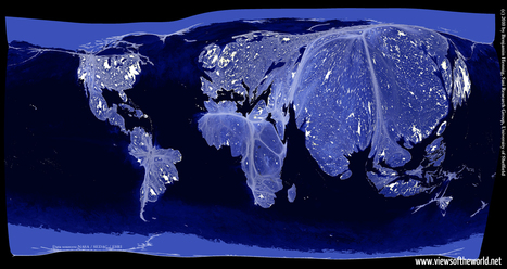
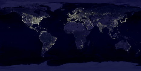
Earlier I have posted the classic image of "Earth Lights at Night," and discussed the classroom uses of the image.  This cartogram helps take that analysis one step further.  This cartogram helps students to visualize the magnitude of population (with the cartogram adjusting area for population) and then to see the patterns of energy use, global consumption and urbanization with in a new light. 


Tags: remote sensing, worldwide, consumption, poverty, population, spatial, political, regions.

No comment yet.
Scooped by Dot MacKenzie
Scoop.it!

Perplexus - The Best Spatial Toy

Perplexus - The Best Spatial Toy | IELTS, ESP, EAP and CALL | Scoop.it

This is the best 3-D maze I've ever seen...kids of all ages love it (I really am just a kid at heart).  But for geography teachers, this maze gets people to use spatial cognition to understand the overall pattern.  For tactile students, this is a great item to have in a classroom. 

No comment yet.
Scooped by Dot MacKenzie
Scoop.it!

Indo-European Languages Originated in Anatolia, Biologists Say

Indo-European Languages Originated in Anatolia, Biologists Say | IELTS, ESP, EAP and CALL | Scoop.it
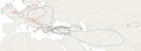
Evolutionary biologists say the first speakers of what would become the Indo-European languages were probably farmers in what is now Turkey — a conclusion that differs by hundreds of miles and thousands of years from a longstanding linguistic theory.


This research potentially can explain much about the geography of languages and the distribution of cultural groups in Eurasia. 

No comment yet.
Scooped by Dot MacKenzie
Scoop.it!

Earth's City Lights

Earth's City Lights | IELTS, ESP, EAP and CALL | Scoop.it
NASA's Visible Earth catalog of NASA images and animations of our home planet...


This classic image is full of classroom applications.  The first impulse of most students is to note that this image will show us where people live, where the cities are or some other comment that speaks to the magnitude of the population in the white areas.  Let them analyze this for more time, and they'll notice that population isn't the whole story of this image.  A place like India shines, but less brightly than the eastern part of the United States.  I like to point out that South Korea appears to be an island (because North Korea is literally blacked out).  Politics, development, affluence and population information are all embedded in this image.  As with all maps, the more information you have about the place in question (in this case, Earth), the more meaningful information you can extract out of the map. 


Tags: remote sensing, worldwide, consumption, poverty, population, spatial, political, regions.

No comment yet.