IELTS, ESP, EAP and CALL
18.5K views | +0 today
Follow
IELTS, ESP, EAP and CALL
Interesting links and articles related to IELTS, ESP, EAP and E-learning.  Available to teach ESP, EAP, Research Skills, IELTS, TOEFL and General English.
Curated by Dot MacKenzie
Your new post is loading...
Scooped by Dot MacKenzie
Scoop.it!

The Archipelago of Eastern Palestine

The Archipelago of Eastern Palestine | IELTS, ESP, EAP and CALL | Scoop.it

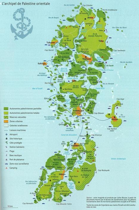
The shape of a state can greatly impact the political cohesion of a country as well as it's economic viability.  While this is obviously a fictitious map, it draws our attention to the logistic difficulties that confront Palestine with the Israelis controlling crucial transportation access points and corridors.   


Questions to Ponder:  How is this a 'persuasive map?' What are some of the geographic impacts of this fragmentation on Palestine? For Israel?


Tags: cartography, MiddleEast, political, states, territoriality, unit 4 political.

No comment yet.
Rescooped by Dot MacKenzie from Regional Geography
Scoop.it!

What is in a Name?

What is in a Name? | IELTS, ESP, EAP and CALL | Scoop.it

Tags: Middle East, political, states, perspective, unit 4 political.


Via Seth Dixon
James Hobson's curator insight, October 28, 2014 10:07 AM

(Africa topic 2)

Asking what lies within a name is more of a subjective question than it is objective. Yes, all names have some sort of meaning or origin behind them, but it isn't always relevant. I doubt that my friends really ever wonder why my last name is Hobson; they just use it to refer to and identify me. On the other hand, a genealogist might take great interest. Similarly, it seems as if the dispute of regional names, such as Israel and Palestine, has a similar contradiction: some just want to refer to the region in the easiest, most familiar way possible, while others take it directly to heart. Perhaps more of a distinction should be made between physical and political naming conventions. An example would be classifying Israel and Palestine to both be in the physical region of Palestine, whereas certain areas (which are still being debated) should be referred to as Israel when speaking politically.

Samuel D'Amore's curator insight, December 16, 2014 2:56 AM

While this comic is clearly done in jest it really highlights the importance a name holds to people. Their are some issues which heavily divide people, in this case the tensions between Israel and Palestine and lead to the formation of very strong opinions. With these opinions come the aspect of properly assigning a title to them. In some cases the same thing is known by many names and is highly contested.  

Scooped by Dot MacKenzie
Scoop.it!

Votes and Vowels: A Changing Accent Shows How Language Parallels Politics

Votes and Vowels: A Changing Accent Shows How Language Parallels Politics | IELTS, ESP, EAP and CALL | Scoop.it

"It may seem surprising, but in this age where geographic mobility and instant communication have increased our exposure to people outside of our neighborhoods or towns, American regional dialects are pulling further apart from each other, rather than moving closer together. And renowned linguist William Labov thinks there’s a connection between political and linguistic segregation.


"Labov suggests that it’s these deep-seated political disagreements that create an invisible borderline barring the encroachment of Northern Cities Vowels. When he looked at the relationship between voting patterns by county over the last three Presidential elections and the degree to which speakers in these counties shifted their vowels, he found a tight correlation between the two. And the states that have participated in the vowel shift have also tended to resist implementing the death penalty.


"Social identities are complex, and can be defined along a number of different dimensions like class, race, or ethnicity. Not everyone feels that politics are a part of their core identity. But I suspect that political ideology may become an anchor for accents to the extent that large social groups collectively identify themselves by their political beliefs. According to Bill Bishop, author of The Big Sort, this is happening more and more as Americans voluntarily cluster themselves into homogenous, politically like-minded communities."

No comment yet.
Scooped by Dot MacKenzie
Scoop.it!

Countries Participating in the 2012 Olympic Games in London

Countries Participating in the 2012 Olympic Games in London | IELTS, ESP, EAP and CALL | Scoop.it
Discover the number of countries participating in the 2012 Summer Olympic Games in London. Find out which countries are not participating in the Olympic Games and learn which non-countries are participating as well.


204 countries are participating in the Olympics?  There aren't even 204 countries in the world!  This article looks at the political geography of international recognition.   One interesting case not discussed in the article is that of Taiwan.  Taiwan is participating, but marched under a non-Taiwanese flag under the name Chinese Taipei because the IOC wanted the mainland Chinese to return to the games. Also, South Sudan, Kosovo and the Vatican are not participating (although pondering them competing, especially the Vatican, is something that deeply amuses me).  Another intriguing thought: how many of the participants were former British colonies?   There are more classroom resources based on the Olympics from the GA.

Jason Charles Wright's curator insight, April 27, 2017 11:51 AM
Countries are participating in the Olympics, but are not even a country. These countries are not even under the proper flag like Taiwan and South Sudan and Kosovo and the Vatican. 
Scooped by Dot MacKenzie
Scoop.it!

England, Britain and the UK

England, Britain and the UK | IELTS, ESP, EAP and CALL | Scoop.it

This is the short version of the differences between these interrelated places and terms; the long version is much more complicated than this. 


Tags: Europe, political, unit 4 political, states, toponyms.

James Hobson's curator insight, October 9, 2014 11:05 PM

(Europe topic 7)

Perhaps this "short" version would've been a better starting point for those less familiar with the terminology. :-) And at least this doesn;t have to be edited to include an independent Scotland, which might've sparked a debate about the terms "U.K." and "Great Britain."

Nonetheless, this serves as a great example of the often-overlooked contrast between physical and political boundaries. Perhaps a simpler example would be "the Americas" (physical) and "the United States of America" (political).

Perhaps one peculiarity which I can relate to this example is that of "Bristol County", a term used seemingly interchangeably between all towns in east-central Rhode Island and nearby Massachusetts. Though currently these are 2 separate counties in 2 different states which just happen to bear the same name, realizing the history behind all of these types of examples can offer further insight into the geographic contexts (physical, political, personal, etc.)

Wilmine Merlain's curator insight, December 18, 2014 1:52 PM

Its no wonder people often get confused when referencing the UK, Britain Isles and Great Britain. I sometimes struggle with the terms and being able to locate where each of the 5 countries fall under. This diagram does a good job at pinpointing where each of the 5 countries on the eastern border of Europe lies.Great Britain consist of Scotland, England, and Wales. The United Kingdom consist of Scotland, England, Wales and Northern Ireland, While Ireland consist of the Republic of Ireland and Northern Ireland. And finally the British Isles consisting of all the countries within. This raises the question, if Northern Ireland is a part of the United Kingdom, is their identity shared also with the Republic of Ireland?

Adam Deneault's curator insight, December 7, 2015 3:20 PM

To be honest here, this map clarifies a lot of things for myself. I never understood what the British Isles were compares to the UK, Great Britain and England. People used to confuse me all the time and they would refer to England as the UK or Great Britain. Now, I understand England is it's own country and it is part of the UK which is a combination of countries, where as Great Britain is just Three areas, which also include England in it. Now, I fully understand the concept of the United Kingdom and Great Britain. . 

Scooped by Dot MacKenzie
Scoop.it!

Exclusive Economic Zones

Exclusive Economic Zones | IELTS, ESP, EAP and CALL | Scoop.it

Today, a country’s marine economic area is defined by its Exclusive Economic Zone (EEZ), a 200-nautical mile-wide (370 km) strip of sea along the country’s national coast line (hi-res image). This regulation, which was installed by the ‘UN Convention on the Law of the Sea’ in 1982, grants a state special rights to exploit natural (such as oil) and marine (for instance fish) resources, including scientific research and energy production (wind-parks, for example).


Questions to ponder: how does this series of buffer zones around the Earth's land masses impact politics, the environment and local economies?  Where might the EEZs be more important to the success of a country/territory than other regions? 


Tags:  economic, environment, political, resources, water, sovereignty, coastal, environment depend, territoriality, states, conflict, unit 4 political.  

No comment yet.
Scooped by Dot MacKenzie
Scoop.it!

The Corner Where Afghanistan, Iran and Pakistan Meet

The Corner Where Afghanistan, Iran and Pakistan Meet | IELTS, ESP, EAP and CALL | Scoop.it
In the dusty triangle where Afghanistan, Iran and Pakistan meet, there is more than one war going on.


Geopolitically, there is a fascinating confluence of competing interests at this border.  This is "the scariest little corner of the world." It's a dangerous place that is often beyond the authority of any of state.  It also represents (depending on how you divide the world up) at the intersection of the three major regions in the area: Central Asia, the Middle East and South Asia.      


Tags: Afghanistan, political, borders, MiddleEast, SouthAsia, Central Asia, unit 4 political.

Cam E's curator insight, March 4, 2014 11:35 AM

A meeting of different worlds at a border. I can't imagine the things one would see or hear living or growing up on a border of conflict such as this. Refugees are a common site, and no authority can dominate the others, making the area effectively lawless.

Maria la del Varrio's curator insight, December 13, 2014 3:19 PM

This note talk about the place in the desert where three hostile countries confront each other on the infinite war.

Matt Danielson's curator insight, October 30, 2018 11:17 PM
This lawless  region with no government control seems it can be a dangerous region, but also a region were Afghanistan's people can attempt to seek a better life. It reminds me in some ways of the border region with Mexico and the Us. How smugglers try to sneak people in, and deportations occurring, and criminals taking advantage of this situation.  
Rescooped by Dot MacKenzie from Regional Geography
Scoop.it!

The Difference between the United Kingdom, Great Britain and England Explained


Via Seth Dixon
Jacob Crowell's curator insight, December 8, 2014 12:09 PM

As an outsider looking in the concept of the United Kingdom is a little confusing. We are taught to view Scotland as its own country, but they are countries within a larger structure. This video makes what would confuse many Americans and condenses it into a clear video that is just about 5 mins.

Kaitlin Young's curator insight, December 12, 2014 4:38 PM

Many people often interchange the UK, Great Britain, and England, but in reality, they all describe different different things. The UK is a country of four countries, each with equal power, including Scotland, Northern Ireland, England, and Wales but they are all considered British citizens.UK is a political term, describing a country. Great Britain is a physical geographical term describing the land mass containing Scotland, Wales, and England.  The British Isles refers to both Great Britain and the Island of Ireland. All of these terms describe different things, being characterized by either political affiliation or geographic characteristics. 

Kelsey McIntosh's curator insight, March 31, 2018 1:47 PM
This video, created by C. G. P. Grey, explains the difference between the United Kingdom, England, and Great Britain. In the video, he explains that the U. K. is multiple countries which includes England, Scotland, Northern Ireland, and Wales. Great Britain is A geographical term that refers to the land mass that holds England, Scotland, and Wales. This is the largest island in the British isles. The second largest island is called Ireland and contains Northern Ireland and the Republic of Ireland. England is the most populated country in the British Isles and is a part of the UK and Great Britain.
Scooped by Dot MacKenzie
Scoop.it!

The United Nations at a Glance

The United Nations at a Glance | IELTS, ESP, EAP and CALL | Scoop.it
This is the site for the United Nations at a Glance. Here you will find information and links on history, members, visitis, employement and other details.


While some critize the ineffectiveness of the organization, the United Nations remains a key organization to get understanding modern geopolitics.  Through their UN voting patterns, we can assess the geopolitical motivations, interests and alliances of member states.  Also, initiatives (whether successful or not) and highlight the important issues of the day that globally aware students should understand.  

No comment yet.
Scooped by Dot MacKenzie
Scoop.it!

A History of Conflicts

A History of Conflicts | IELTS, ESP, EAP and CALL | Scoop.it
Browse the timeline of war and conflict across the globe.


This database of global wars and conflicts is searchable through space and time.  You can drag and click both the map and timeline to locate particular battles and wars, and then read more information about that conflict.  This resource would be a great one to show students and let them explore to find what they see as interesting.  This site is brimming with potential.     

olsen jay nelson's comment, August 16, 2012 7:46 AM
This is just what I've been looking for, believe it or not:-)
Sakis Koukouvis's comment, August 16, 2012 8:06 AM
Oh... You are lucky ;-)
Paul Rymsza's comment, August 22, 2012 2:15 PM
the potential of this site is amazing between the interactive learning system and the correlation between the timeline and location. If the human geography class is anything like this i can't wait for it!
Scooped by Dot MacKenzie
Scoop.it!

The New World

The New World | IELTS, ESP, EAP and CALL | Scoop.it
An interactive series of maps show possible new additions to the world’s list of independent nations.


This is great way to show examples of devolution and political instability.  Included are 11 potential scenarios where further fragmentation/disintegration might occur or even greater regional integration that would redraw the map.  These case studies include: Somalia, Korea, Azerbaijan, Belgium and the Arabian Gulf Union.


Tags: political, devolution, supranationalism, war, autonomy, unit 4 political.

Anna Sasaki's curator insight, March 24, 2015 8:53 AM

This article is probably one of my favorites I have read so far. It describes perfectly the political instability still present in the world, and that the globe and its boundaries are constantly changing, never staying put for too long. It surprised me at the new borders which most likely are going to happen, such as the unification of parts of Pakistan and Afghanistan. Also, the fact that South Korea is subtly getting ready for the reunification of North and South Korea. Also, there may be devolution in Mali and splintering devolution in the Congo's.

This shows devolution as the power in these nations in which are breaking up, such as Belgium and the Flemish peoples. It shows the centrifugal forces behind the breakup of nations, such as ethnicities which vary, or the centripetal forces which bring nations together such as the combination of South and North Korea. 

Caroline Ivy's curator insight, May 21, 2015 11:12 AM

Devolution/Fragmentation


This article is about nations that could become potentially independent in the near Future, whether due to chronic ethnic incoherence, redrawn governemnt policies, or a growing stateless nation group. Some examples given are an independent Khurdistan, a larger Azerbaijan, and the split of Belgium. 


Centrifugal forces are the root of conflict in many countries. These forces include ethnic variety, lack of common language, political instability. These are what may be causing a split in both Belgium (developed country) and Somalia (developing country). There may also be a unification of countries—the map gives an example of the Saudia Arabia, Oman, Yemen, Bahrain, and other melding into one Arabian Gulf Union, of China absorbing Siberia. This does not necessarily herald the presence of centripetal forces, as these countries may be the result of military conquest.