IELTS, ESP, EAP and CALL
18.5K views | +0 today
Follow
IELTS, ESP, EAP and CALL
Interesting links and articles related to IELTS, ESP, EAP and E-learning.  Available to teach ESP, EAP, Research Skills, IELTS, TOEFL and General English.
Curated by Dot MacKenzie
Your new post is loading...
Scooped by Dot MacKenzie
Scoop.it!

Homes across the world, from above

Homes across the world, from above | IELTS, ESP, EAP and CALL | Scoop.it
View Homes across the world seen from up high pictures on Yahoo!. See Homes across the world seen from up high photos and find more pictures in our photo galleries.


This aerial photography gallery shows distinct types of urbanism and is a good portal to introduce a class to suburban landscapes. 

No comment yet.
Scooped by Dot MacKenzie
Scoop.it!

Earth's City Lights

Earth's City Lights | IELTS, ESP, EAP and CALL | Scoop.it
NASA's Visible Earth catalog of NASA images and animations of our home planet...


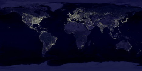
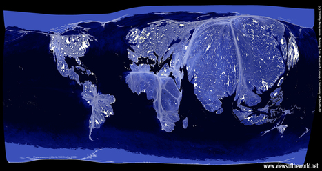
This classic image is full of classroom applications.  The first impulse of most students is to note that this image will show us where people live, where the cities are or some other comment that speaks to the magnitude of the population in the white areas.  Let them analyze this for more time, and they'll notice that population isn't the whole story of this image.  A place like India shines, but less brightly than the eastern part of the United States.  I like to point out that South Korea appears to be an island (because North Korea is literally blacked out).  Politics, development, affluence and population information are all embedded in this image.  As with all maps, the more information you have about the place in question (in this case, Earth), the more meaningful information you can extract out of the map. 


Tags: remote sensing, worldwide, consumption, poverty, population, spatial, political, regions.

No comment yet.
Scooped by Dot MacKenzie
Scoop.it!

Earth from Above

Earth from Above | IELTS, ESP, EAP and CALL | Scoop.it

I'm a huge fan of Yann Arthus-Bertrand's artistic aerial photography.  This image of Rio de Janeiro and the favela is a striking one. I am also posting this to show the how easy the website justpaste.it is to use.  Students with no website creation training can produce sharable materials online.  Now this isn't the most professional outlet, but I envision some middle school or high school students producing a class project that can be transformed into something that reaches a bigger audience as it is shared with a broader community. 


Tags: remote sensing, images, art, worldwide, K12, edtech.

No comment yet.
Scooped by Dot MacKenzie
Scoop.it!

"The Most Amazing High Definition Image of Earth Ever," Says NASA

"The Most Amazing High Definition Image of Earth Ever," Says NASA | IELTS, ESP, EAP and CALL | Scoop.it
NASA has released a new Blue Marble image, showing the United States of America. According to them, it's the "most amazing, highest resolution image of Earth ever." Blue Marble 2012 bests the 2010 edition and the original one.


Beautiful image...follow the link for a video of the image at a variety of scales as well as the specs and production that went into it.   There is an 8000 x 8000 pixel version as well as many lower resolution versions. 


No comment yet.
Scooped by Dot MacKenzie
Scoop.it!

The Real World at Night

The Real World at Night | IELTS, ESP, EAP and CALL | Scoop.it

Earlier I have posted the classic image of "Earth Lights at Night," and discussed the classroom uses of the image.  This cartogram helps take that analysis one step further.  This cartogram helps students to visualize the magnitude of population (with the cartogram adjusting area for population) and then to see the patterns of energy use, global consumption and urbanization with in a new light. 


Tags: remote sensing, worldwide, consumption, poverty, population, spatial, political, regions.

No comment yet.