
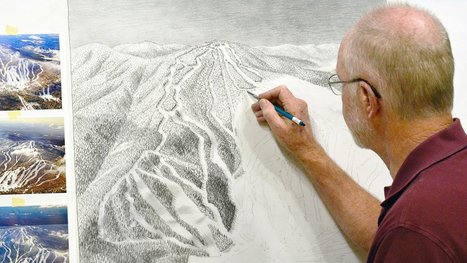

"The ski trail map at your local mountain was probably painted by James Niehues. Now you can see his life's work in one beautiful book."
Get Started for FREE
Sign up with Facebook Sign up with X
I don't have a Facebook or a X account


 Your new post is loading...
 Your new post is loading...
Your new post is loading...
"The ski trail map at your local mountain was probably painted by James Niehues. Now you can see his life's work in one beautiful book." 
No comment yet.
Sign up to comment
|
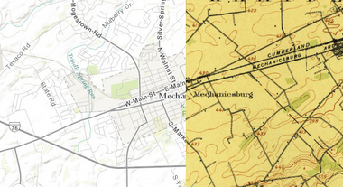
"This cool new historic mapping app from the folks at esri and the U.S. Geological Survey is worth exploring. What it does is take 100 years of USGS maps and lets you overlay them for just about any location in the nation. That allows users to see how a city – say Harrisburg – developed between 1895 and today. The library behind the project includes more than 178,000 maps dating from 1884 to 2006."

PIRatE Lab's curator insight,
August 13, 2014 12:25 PM
For more ESRI maps that let you explore urban environmental change, the 'spyglass' feature gives these gorgeous vintage maps a modern facelift (but not available for as many places). The cities that are in this set of interactive maps are: Chicago (1868)Denver (1879) Los Angeles (1880)Washington D.C.(1851)New York City (1836)San Francisco (1859) |


