
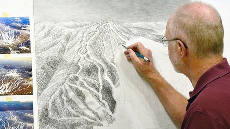
"The ski trail map at your local mountain was probably painted by James Niehues. Now you can see his life's work in one beautiful book."
Get Started for FREE
Sign up with Facebook Sign up with X
I don't have a Facebook or a X account


 Your new post is loading...
 Your new post is loading...
Your new post is loading...
"The ski trail map at your local mountain was probably painted by James Niehues. Now you can see his life's work in one beautiful book." 
No comment yet.
Sign up to comment
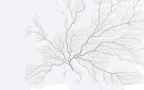
"As the saying goes, 'All roads lead to Rome.' Folks at the moovel lab were curious about how true this statement is, so they tested it out. They laid a grid on top of Europe, and then algorithmically found a route from each cell in the grid to Rome, resulting in about half a million routes total. Yep, there seems to be a way from Rome from every point."
Tags: fluvial, mobility, transportation, mapping.

Gilbert C FAURE's comment,
January 24, 2016 11:09 AM
a new geography of europe! fascinating for politicians
Gilbert C FAURE's curator insight,
January 24, 2016 11:10 AM
une nouvelle géographie de l'Europe! pour les politiques!! 
Leonardo Wild's curator insight,
January 24, 2016 1:00 PM
But many roads didn't leave Rome ... a small detail that has been lost to history.
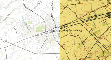
"This cool new historic mapping app from the folks at esri and the U.S. Geological Survey is worth exploring. What it does is take 100 years of USGS maps and lets you overlay them for just about any location in the nation. That allows users to see how a city – say Harrisburg – developed between 1895 and today. The library behind the project includes more than 178,000 maps dating from 1884 to 2006."

PIRatE Lab's curator insight,
August 13, 2014 12:25 PM
For more ESRI maps that let you explore urban environmental change, the 'spyglass' feature gives these gorgeous vintage maps a modern facelift (but not available for as many places). The cities that are in this set of interactive maps are: Chicago (1868)Denver (1879) Los Angeles (1880)Washington D.C.(1851)New York City (1836)San Francisco (1859) |
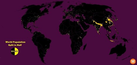
"Data viz extraordinaire Max Galka created this map using NASA’s gridded population data, which counts the global population within each nine-square-mile patch of Earth, instead of within each each district, state, or country border. Out of the 28 million total cells, the ones with a population over 8,000 are colored in yellow."
Tags: population, density, mapping, visualization.

Brian Weekley's curator insight,
July 27, 2016 10:47 AM
Great simple map of world population. Scroll down and look at the U.S. It reflects the global trend. This also has political implications, as evidenced by voting patterns in the 2012 presidential election. Elections are dependent upon votes, which come from people, which are primarily clustered in cities. Election campaigns would use this data to plan their schedules as to where to focus their campaigning efforts. For the folks in Wyoming, they rarely see candidates other than during the primaries. And these world populationclusters have been relatively consistent historically, particularly in south and east Asia. Northern India has serious carrying capacity challenges. Notice the clusters along the Nile- evidence of arable land.

From
www

The Royal Institute of Navigation says reliance on sat-navs is undermining map-reading skills. So why should we still read maps?

Catherine Lamarque's curator insight,
June 6, 2015 5:55 AM
Lire un carte est toujours le début d'une histoire...
|


