

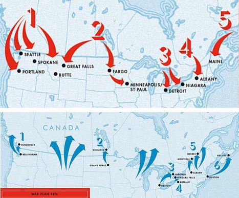

After World War I, Canada drew up classified plans to invade the U.S. Meanwhile, the U.S. had its own secret plot to create the "United States of North America."
Get Started for FREE
Sign up with Facebook Sign up with X
I don't have a Facebook or a X account


 Your new post is loading...
 Your new post is loading...
Your new post is loading...
After World War I, Canada drew up classified plans to invade the U.S. Meanwhile, the U.S. had its own secret plot to create the "United States of North America."
Seth Dixon's insight:
I never knew 1921 to 1930 was such a frosty time in Canadian-U.S. relations that BOTH sides drew up possible invasion plans. Judging by these amazing arrows, these plans were never seriously about to be executed, but it is a good reminder that geopolitical partnerships (and rivalries) are ever-changing. Today, if there are border tensions between these two allies, it might just center around the Arctic as it's geopolitical importance is rising, but the U.S. doesn't have a very successful track record against Canada. Also, I did enjoy the 1920s reference that Americans simply assumed that Canada (once the British Empire was dismantled) would naturally be absorbed by the United States. Tags: Canada, geopolitics, political, war. 
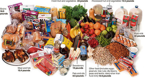
Food riots are breaking out abroad but Americans toss a lot of their food in the garbage.
What do you consider "garbage" when it comes to food? Take a look at what the average American family wastes each month, and think about where that food could have gone.
"As urgency rises over need to halt the migration of invasive Asian carp into the Great Lakes, a new solution comes forward: Eat them.(...)"

Peter Siner's comment,
November 16, 2011 10:10 PM
thats one way to solve hunger issues... just eat your problems, i wonder what other impacts this will have ecologically speaking

's comment April 12, 2012 1:50 PM
Any time we introduce a new species we are opening the Pandora's box, but as we all wait for Hope to emerge, it maybe too late and the damage is done.

Stacey Jackson's curator insight,
February 22, 2013 1:04 AM
This article reminded me of a book I read a while back,"Eating Aliens: One Man's Adventures Hunting Invasive Animal Species" by Jackson Landers. Among the creatures that he suggests eating in order to keep the populations under control: green iguanas, armadillos, lionfish, European green crabs, Canadian Geese, and Asian carp. It is an interesting concept that I believe could actually work, after all we have driven animals to extinction in the past, however we would need some creative chefs and commercial fishers to take it on. I don't think the general public is going to hunt enough Asian carp to do the job.

Non-Hispanic whites make up a dwindling share of the nation’s population, as their numbers drop in the Northeast and Midwest and grow slowly in the South and West.
A while back we looked at the changing demographics of black America, now it's time to look at the changes in white America. Why is this happening? What economic, cultural, demographic and political factors contribute to this pattern? What push factors and pull factors are at work?
Also, look at the interactive graphic, with mappable census data from the last 30 years, aggregated at the county level, or even block level. Link at: http://www.washingtonpost.com/wp-srv/special/nation/census/2010/

Exceelnt electoral geography maps from the U.S. presidential election of 2008. What are the major patterns you see? What do these patterns in say about the politics, culture and demographics about these places?

Official U.S. census population clocks for both the United States and the World. 6.9 billion and still ticking....

James Hobson's curator insight,
September 18, 2014 11:20 PM
North America topic 9) Being a person who likes interactive maps and graphics, I found this website and its data to be especially interesting. I remember seeing the same graphics displayed a few years ago at the Boston Museum of Science. Aside from the actual clock, it was interesting to observe the distribution-by-age graphic, and use its slider bar to see the change over time. Right away I could pick out the year the "baby boom" started. Another discrete trend I noticed is that the percent of the U.S. population aged 100+ has gone up lately (though by hundreds of a percent), which reflects recent medical advances and confirms hypotheses previously made that this would happen.

More than 10 million Americans moved from one county to another during 2008. The map below visualizes those moves. Click on any county to see comings and goings: black lines indicate net inward movement, red lines net outward movement.

Natalie K Jensen's curator insight,
January 30, 2013 10:45 AM
This is a dynamic illustration of international migration in the US that fits nicely within Chapter 3. 
Ellen Van Daele's curator insight,
March 22, 2015 4:51 PM
This map show the immigration and emigration of people in the United States. It gives you a visual representation of all the people moving in and out of an area.
Something I noticed by looking at the map was that there are a huge amount of people leaving and moving in the major cities. Initially I thought that there would be a larger income than outcome in the big cities but the flow seemed pretty stable.

As companies move production overseas and as other industries grow faster, manufacturing is accounting for a smaller share of the economy. And the nation has no distinct plan for the sector’s future.
Full of applications for global economic restructuring, post-industrial economics, outsourcing, rust-belt decline, rise of China, etc.

Ghost Towns: Rural U.S.Disappearing...
1910: 72% of USA rural 2010:16% of USA rural
This stark reversal has profoundly reshaped our society. The patterns noted in Peirce Lewis's 1972 classic article "Small Town in Pennsylvania" have just continued and accelerated. Critical questions: What forces are driving the change? What other parts of society are impacted by this shift?

Wilmine Merlain's curator insight,
November 1, 2014 10:03 PM
Our society has been shaped by the migration of its southern residents into northern and western cities. While our cities are overflowing with rural citizens, life in rural America is slowly vanishing to life in the city. Just like times in early America, lack of employment opportunities in the rural America and the blooming business industry in the city, those who had family roots set in rural America are having too uproot their family and relocate in order to participate in the economic trade. 
Edgar Manasseh Jr.'s curator insight,
January 30, 2015 3:41 PM
I think society itself evolves from the past. Alot of new ventures emerge and society adapts to that. Alot of rural areas have evaporated as a new force of urban planning has emerged where more developed cities have increased and more small cities are being recognized and developed into a more open society. Ghost towns are being more destroyed and created into a opportunity where a driven society will create businesses for people with no jobs. 
WILBERT DE JESUS's curator insight,
February 12, 2015 6:44 PM
People move from rural areas to urban areas in the US. This pattern has shifted the notion the founder fathers had when creating this great nation when they envisioned a mostly farming society where people own the land. |

Although most Americans have never heard of Diwali, many Amerian Hindus are encouraging fellow Hindus to be a little more open about their celebrations -- to tell friends, colleagues and their children's teachers that Diwali is a big deal within Hinduism, the world's third largest religion.

More than 600 newcomers per day have arrived in Canada since 2006, and many of them have settled in neighbourhoods like Richmond, B.C.
Globalization has changed North American ethnic patterns as fewer European immigrants are migrating to Canada, and more are coming for Asia. Not surprisingly, the urban areas are the regions were this pattern is most pronounced.

Elizabeth Allen's comment,
December 6, 2012 9:45 PM
Asians have been affiliated with Canada for many years. Many immigrant workers in the 1800s helped Canade build their railroads. Many Vietnamese refugees escaped to Canada during the Vietnam war. Today Asians are still migrating to Canada forming a multi-cultural society. In the 90s most immigrants were able to get cheap land, but now modern prices have inflated.

Al Picozzi's curator insight,
September 9, 2013 11:36 AM
This is what is happening in the U.S. also. As globalization continues more immigrants from non-European countries are heading to the US. The old ethic neighboors, the little Italy for example, are still there but there are not many Italians left. Most left the inner cities for the suburbs, much like in Canada. Amazing to see similar patterns in different countries. 
Cam E's curator insight,
January 29, 2014 1:39 PM
The idea of ethnic enclaves themselves have an interesting commentary of sorts on the current political climate. It's been said time and time again in recent years that diversity is to be celebrated and encouraged, but we can see very clearly that some people do not wish to live in diverse neighborhoods and would rather live with people very similar to themselves. Even the capital of Rhode Island, Providence, is segregated in this sort of way.

Not every place and every citizen has been affected by the recession the same way...
For the Unemployed, Geography Can Be Destiny by Richard Florida. This article highlights the uneven distribution of unemployment, and consequently, of job availability. Where is unemployment highest? How come? Getting a job isn't just about what you know and who you know, but where you know it.

Kaitlin Young's curator insight,
December 15, 2014 1:41 PM
While the media often focuses on unemployment on a grand scale, regional trends can add insight to the problem at hand. Some places, such as Yuma, Arizona, have unemployment rates as high as 30% while other, like Fargo North Dakota have a safe 3% unemployment rate. At the height of the recession, unemployment was decently even across the country, but recovery has not been an even process. Demographics could be a large key to understanding these issues. Large metros are more resilient to unemployment due to the higher quantity of college graduates, and their positions as economic and creativity hubs.

According of one group, the defined what they saw as the 4 essential elements of a state.

Some fun visualizations about the geography of sports fans, specifically where can you get a radio signal for games for the Red Sox or Yankees games.

Brett Sinica's curator insight,
September 27, 2013 12:16 PM
Now this is very interesting. First of all I live along the coast of Eastern Connecticut, which essentially is a battleground between New York and Boston. Sure there is Patriots and Jets/Giants, Celtics and Knicks, but nothing is comparable to the Red Sox and Yankees rivalry. Fortunately my area is covered by the New York radio stations, as well as the Boston stations, but in an area where you're either "for them or for us" it's almost a judgement depending on which team you favor. Growing up it was always fun to have half your friends root for the Red Sox, and half for the Yankees. Yet as I've grown older I've realized it's much more geographical and territorial than I had ever thought. Hands down, the best rivalry in American sports, and I'm lucky enough to be right in the middle of it.
James Hobson's curator insight,
September 15, 2014 9:15 AM
(North America topic 1) Also, I couldn't help but notice the uncannily-large Yankee coverage area posted right in the middle of Rhode Island. I'd think that Hartford would have a larger circle. 
Raymond Dolloff's curator insight,
November 23, 2015 2:39 PM
New England's most famed baseball team! The Red Sox have a storied rivalry with the New York Yankees from the 2004 MLB Playoffs where the Sox won the last four games of the ALCS to be the first team ever to win a series from being 3 games down and on the brink of elimination in all their remaining games in that series. They also compete with the Yankees with radio broadcasts. Fans mainly in Rhode Island, Massachusetts listen to the Red Sox radio Broadcasts. The areas up for dispute where there is competition is extreme southern Rhode Island, Western Connecticut, and areas on Long Island, and Greenwich Connecticut have people who listen to both broadcasts/

One of the most indelible memories in the collective psyche of Americans - and the world - comes from the images of the World Trade Center following the terrorist attacks on the United States, September 11, 2001.
A moving and haunting set of images...how is memory inscriped in the landscape? how does that emotional connection to place transform the functionality and meaning of the place?

"Nike? Gone. Adidas? Gone. New Balance, the last major athletic shoe brand still manufacturing in the United States, fights to keep jobs here." This is an excellent portal for discussing outsourcing, deindutrialization, sectors of the economy and globalization.
Stacey Jackson's comment,
February 7, 2013 5:51 PM
I had no idea that New Balance still manufactured their shoes in the US. Sadly, I assumed they were made overseas as most textiles are these days. I'll have to go out and buy a pair of New Balances now.
Cam E's curator insight,
January 29, 2014 2:03 PM
The United States, known for its industrial prowess in the past, has become a shadow of what it used to be. Our economy has taken a major turn to a majority service oriented one, with about 70 percent of our GDP coming from Consumption rather than production. Even since the year 2000 the US has lost around 32 percent of its manufacturing jobs. All that can be said through my limited knowledge on the topic is that a nation which switches from production to consumption will likely fall behind others on the path of technological advancement.

An excellent suite of images in a photoessay showing urban development in Florida. These collectively can be used to accentuate the "human-environmental interactions" theme of geography. The "unnatural coastlines" shows the economic logic behind this ecologically unwise development pattern.

Jared Medeiros's curator insight,
February 4, 2015 7:08 PM
Its funny how in Florida, these ares are all layed out in a nice and neat plan of development, with some kind of structure, while in the northeast it is a free for all, build it where you can kind of area. It is funny though how close these houses are to each other when there is so much land around in all areas. 
Mackenzie Mcneal :)'s curator insight,
March 10, 2015 9:07 PM
As you can see Florida has grown not only with its population but with its economical development. With the Urban patterns being so widely distributed it has made a major imapct with how Florida is catorgarized. With the spread of development being so highly rated it has not only moved farther up into the upper parts of Florida, but all over, this has caused Florida's ubanized patterns to look scrambled and not in an orderly fashion. 
Rylee English's curator insight,
February 5, 2016 10:09 AM
these images give examples of areas/ regions that used to be empty, open fields but were developed into suburban areas with many subdivisions and housing for citizens. RE |


It's very interesting to see how neighbor countries don't really get along as to how one thinks they would. Who would of thought Canada actually had plans to invade the U.S.? Isn't it a good thing to have your allies like best friends? Canada had this plan during the 1920s and had 5 intrusion entries. its interesting to see how one of the intrusion points would of been Seattle. In my opinion, this could of been a really bad for both countries. Overall, now I would like to know how 'well' the relationship is between the two countries.