


 Your new post is loading...

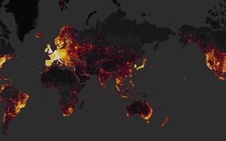

A secretive special air service base has been inadvertently revealed by a fitness app that has created a heatmap of running routes around the country.
A SAS base in Hereford, along with a nuclear deterrent naval base and the government's spy agency GCHQ has been placed on a heatmap of Strava's customers, including the profiles of several people who regularly run to-and-from the highly sensitive buildings.
The buildings appear on a global, interactive map created by Strava, which is an app that allows users to track cycling or running speeds and distances and share them with friends. But unbeknown to many of its users, Strava has used their location data to in a worldwide heatmap including three trillion coordinates, titled "Where We Play".
"When sensitive sites, such as the GCHQ, are quite literally highlighted by GPS activity, it raises concern not only for the individual connected to the device, but the institution as a whole. The UK’s security services must be hyper-aware of what they’re sharing – regardless of what may be labelled as ‘excluded’ within the device. If a device or application has the capability to share location in any respect, it signifies a breach in security protocols."
Learn more / En savoir plus / Mehr erfahren:
https://gustmees.wordpress.com/2012/11/05/naivety-in-the-digital-age/
https://www.scoop.it/t/securite-pc-et-internet/?&tag=wearables