Education in a Multicultural Society
1.1K views | +0 today
Follow
Your new post is loading...
Rescooped by Dennis Swender from HMHS History
Scoop.it!

How Does the U.S. Census Bureau Define Rural?

"The U.S. Census Bureau has designed a multimedia application experience, a story map, called 'Rural America: How Does the U.S. Census Bureau Define Rural?' This story map contains interactive web maps, tables, information, and images to help explain how the Census Bureau defines 'rural.' Many rural communities rely on American Community Survey (ACS) 5-year estimates, rather than ACS 1-year estimates, because of population thresholds. This story map helps data users understand the history and definition of 'rural.' Watch this video and then visit the story map to learn more." Visit the Story Map: http://go.usa.gov/x8yPZ  


Via Michael Miller
Matt Manish's curator insight, February 16, 2018 10:57 PM
The U.S. Census Bureau defines "rural" as an area with less than 50,000 people living in it. The majority of the United States is actually considered rural while a small minority of the country is labeled as urban. But interestingly enough, most rural areas are clustered around urban areas rather than in random locations. It seems as though the further out one ventures out from the center of an urban area like a major city, the more the population begins to decrease. One can also see in the same situation, the area transition from urban to rural. U.S. Census data can tell us a lot about populations in rural and urban areas and the correlation between them which can be important to know for many reasons.
Frances Meetze's curator insight, September 10, 2018 1:19 PM
population
Scooped by Dennis Swender
Scoop.it!

How Does the U.S. Census Bureau Define Rural?

"The U.S. Census Bureau has designed a multimedia application experience, a story map, called 'Rural America: How Does the U.S. Census Bureau Define Rural?' This story map contains interactive web maps, tables, information, and images to help explain how the Census Bureau defines 'rural.' Many rural communities rely on American Community Survey (ACS) 5-year estimates, rather than ACS 1-year estimates, because of population thresholds. This story map helps data users understand the history and definition of 'rural.' Watch this video and then visit the story map to learn more." Visit the Story Map: http://go.usa.gov/x8yPZ  

Matt Manish's curator insight, February 16, 2018 10:57 PM
The U.S. Census Bureau defines "rural" as an area with less than 50,000 people living in it. The majority of the United States is actually considered rural while a small minority of the country is labeled as urban. But interestingly enough, most rural areas are clustered around urban areas rather than in random locations. It seems as though the further out one ventures out from the center of an urban area like a major city, the more the population begins to decrease. One can also see in the same situation, the area transition from urban to rural. U.S. Census data can tell us a lot about populations in rural and urban areas and the correlation between them which can be important to know for many reasons.
Frances Meetze's curator insight, September 10, 2018 1:19 PM
population
Scooped by Dennis Swender
Scoop.it!

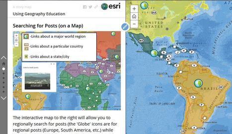
Using 'Geography Education'

Using 'Geography Education' | Education in a Multicultural Society | Scoop.it

"This story map was created with ArcGIS Online to guide users on how to get the most out of the Geography Education websites on Wordpress and Scoop.it."

Ruth Reynolds's curator insight, December 3, 2016 9:33 PM
Just getting familiar with ArcGis and lots of ideas picked up at #ncss16
Olivia Campanella's curator insight, September 5, 2018 4:09 PM
This map is a very helpful, useful and fun guide on how to get the most of this website and to learn about geography and different places and facts of the world. 
Dominic Mappas's curator insight, June 5, 2019 6:41 AM
This source allows its viewers to select countries to direct them to a series of topic links. This allows the audience to interact and explore the world through visual representation of the globe. I can see this being implemented for warm up activities, quizzes and practice questions. Great source! 
Scooped by Dennis Swender
Scoop.it!

Urban Observatory

Urban Observatory | Education in a Multicultural Society | Scoop.it

The Urban Observatory city comparison app enables you to explore the living fabric of great cities by browsing a variety of cities and themes.

Utiya Chusna Sitapraptiwi's curator insight, July 15, 2013 5:44 AM

Easy to find a picture of the city in the world. 

Matthew DiLuglio's curator insight, October 12, 2013 5:45 PM

I have been using Google Earth to check out a few different areas that I have and have not been to, particularly Washington D.C./Maryland, which I visited last month for the first time.  I thought it was truly awesome and loved all the subtle differences as well as the larger and more obvious differences from RI.  This Observatory is pretty interesting, and doesn't limit your observations to strictly visual perceptions, unlike most Astrological Observatories.  It is a compendium of knowledge, information, and facts that define and characterize, categorize and redefine areas of the world.  This seems like something out of Minority Report or Deja Vu (two really good sci-fi movies with visual observation technology that looks through time), both because of its appearance, and because of its general function.  It also reminds me of some stuff that I've seen in the 1967 "The Prisoner" series, which really blew my mind about sociological portayals of the occasionally subversive human condition from entirely oppressing parties and circumstances.  Hopefully this information will, as comes with great power, be treated with great responsibility... For all our sakes.

David Week's curator insight, August 12, 2014 6:05 PM

Nice. I'm going to try it.

Scooped by Dennis Swender
Scoop.it!

The Two Koreas

The Two Koreas | Education in a Multicultural Society | Scoop.it

"While the Korean War of the early 1950s never formally ended, its aftermath has created starkly divergent worlds for those living on either side of the north-south divide. What follows is a look at life in the two Koreas; how such a night-and-day difference came to be; and where the crisis could go from here. Both governments claimed to be the legitimate rulers of the peninsula. Tensions between north and south gradually mounted, until finally, in June 1950, hundreds of thousands of North Korean troops stormed across the 38th parallel. The unsuspecting South Korean defenders were outgunned and outnumbered, and beat a hasty retreat southward."

Stevie-Rae Wood's curator insight, December 9, 2018 9:10 PM
The two Koreas are polar opposites literally, North and South. The Korean war that took place some 68 years ago never formally ended because they could not come to peace agreements. So the border between North and South Korea known as the DMZ is the most heavily fortified border in the world because tensions still run high. The DMZ is the cease fire line. Both sides fear invasion, however in the current state of things it seems as if the North is more aggressive towards invasion that the South, as the South has found some secret tunnels and fear there's more by the North Koreans. Economically the North is severely behind in the world because of there dictators. While the South has become an economic Tiger thanks to the UN and USA trying to promote democracy in the area.
Matt Danielson's curator insight, December 12, 2018 3:51 PM
The two Koreas are a great example of how Capitalism, Democracy, and liberty are far better than Communism. Just the difference in light visible from satellites at night in the two countries speaks volumes. The war being technically not over and only under cease-fire always leaves that chance for the conflict to reopen. Though today they are taking major steps toward peace and making moves that have never been done before. The amount of famine and overall  sub quality of life in North Korea is mind blowing, and with much of it kept secret its hard to imagine how bad it really is.
Kelvis Hernandez's curator insight, December 14, 2018 3:54 PM
For the two Korean nations, there are stark contrasts in the standard of living and wealth of the people. While the Korean war began in the 1950's it never formally ended a ceasefire was called and has just not flared up in a massive battle again. The two nations are uneasy with each other having different ideas for what Korea should be, but both nations do want a joint Korea. Looking at a map of the energy consumption by the two nations there is a line between those who have it and those who do not. These two have shown solidarity as well in the Olympics joining as one nation, but tensions will continue to flare for a long time.
 
Rescooped by Dennis Swender from Cultural Geography
Scoop.it!

Esri Story Map Treasure Hunt

Esri Story Map Treasure Hunt | Education in a Multicultural Society | Scoop.it

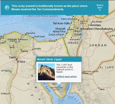
Although these were designed specifically for GIS day during Geography Awareness Week, these 2 excellent map-based treasure hunts from ESRI are great any time of year.  The answer to the question will only pop up in you are zoomed in the the right region (SHIFT + Make a box = Zoom to area).  These links will take you to the World Cities quiz and also to the Mountains quiz.


Via Seth Dixon
Seth Dixon's curator insight, January 18, 2018 6:54 PM

I love this geography, map-based quiz that let's people explore the world as they learn about some interesting places.  

Douglas Vance's curator insight, January 18, 2018 7:00 PM

This is a brand new and to me, a unique way of exploring global geography by using trivia questions as a means to explore the world.

Kami Romeike's curator insight, April 8, 2018 5:29 PM

I love this geography, map-based quiz that let's people explore the world as they learn about some interesting places.  

Scooped by Dennis Swender
Scoop.it!

Santas Around the World

Santas Around the World | Education in a Multicultural Society | Scoop.it
This story map was created with the Esri Map Tour application in ArcGIS Online.
Vivica Juarez's comment, January 13, 2014 8:10 PM
This was definitely an interesting reading. I believe @Spencer Levesque had a very good point. They all have similar features, but are different in little ways. And who would of thought someone came on New Years too?
Kate Loy's curator insight, January 13, 2014 10:23 PM

I find it very interesting on how other countries precieve Santa Claus. The history on him, what he looks like, how he gets around, and what they call him. Each country perceives him differently, depending on their culture and history. His clothes, age, language, and personality.

Kate Loy's curator insight, January 13, 2014 10:28 PM

I find it very interesting on how other countries perceive Santa Claus. The history on him, what he looks like, how he gets around, and what they call him. Each country precieves him differently, depending on their culture and history. His clothes, age, language, and personality.